
Ofbyld:East Anglia UK Locator Map.svg

Size of this PNG preview of this SVG file: 494 × 600 piksels. Oare resolúsjes: 198 × 240 piksels | 395 × 480 piksels | 633 × 768 piksels | 843 × 1.024 piksels | 1.687 × 2.048 piksels | 1.108 × 1.345 piksels.
Oarspronklik bestân (SVG-bestân, nominaal 1.108 × 1.345 pixels, bestânsgrutte: 303 KB)
Gearfetting
| Beskriuwing |
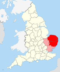
English: Suffolk and Norfolk, the original constituents of East Anglia, are in red. Cambridgeshire – more recently added – in pink.
This image is, inevitably, an approximation and a compromise – it is very hard to properly quantify and emborder East Anglia since it is a completely unofficial region/area. |
||
| Datum | |||
| Boarne |
|
||
| Auteur | User:Nilfanion User:Wkerry | ||
| SVG genesis |


Lisinsje
This file is licensed under the Creative Commons Attribution-Share Alike 3.0 Unported license.
- Fiel jo frij:
- te dielen – it wurk te kopiearjen, fersprieden en út te stjoeren
- te fermingen – it wurk oan te passen
- Under de neikommende betingsten:
- Nammefermelding – You must give appropriate credit, provide a link to the license, and indicate if changes were made. You may do so in any reasonable manner, but not in any way that suggests the licensor endorses you or your use.
- Lyk diele – If you remix, transform, or build upon the material, you must distribute your contributions under the same or compatible license as the original.
Triemskiednis
Klik op in datum/tiid om it bestân te besjen sa't it op dat stuit wie.
| Datum/Tiid | Miniatuer | ôfmjittings | Meidogger | Opmerking | |
|---|---|---|---|---|---|
| lêste | 25 mai 2022, 17.42 | | 1.108 × 1.345 (303 KB) | Judeobasquelanguage | This isn't true, all of us here identify as east anglian, it would be better if you actually asked for the opinions of essexians before denying us our own identity, thanks |
| 30 des 2015, 01.30 |  | 1.108 × 1.345 (302 KB) | Alphathon | Corrected numerous issues introduced in October 2013 revision | |
| 23 okt 2013, 21.05 |  | 1.108 × 1.345 (237 KB) | Gymnophoria | As resolved in the Talk page, Essex is part of the East of England governmental region, but not part of East Anglia. Hence Essex has been removed from the image. | |
| 6 jul 2011, 19.58 |  | 1.108 × 1.345 (303 KB) | Wkerry |
Bestânsgebrûk
De neikommende 2 siden brûke dit bestân:
Globaal bestânsgebrûk
De neikommende oare wiki's brûke dit bestân:
- Gebrûk op af.wikipedia.org
- Gebrûk op br.wikipedia.org
- Gebrûk op ca.wikipedia.org
- Gebrûk op cy.wikipedia.org
- Gebrûk op de.wikipedia.org
- Gebrûk op en.wikipedia.org
- East Anglia
- East Anglian English
- User talk:Dpilat
- User talk:Spidergareth
- User talk:Nhyty
- User talk:BaroqueFox
- User talk:AndrewvdBK
- User talk:Thomas888b/Archive 1
- User talk:DJRYRY11
- Wikipedia:WikiProject East Anglia
- Wikipedia:WikiProject East Anglia/Newsletter
- Wikipedia:WikiProject East Anglia/Newsletter2
- User talk:Rcsprinter123/Archives/5
- User talk:Cmglee/archive2011
- User talk:Chrisjj/Archive 1
- Gebrûk op es.wikipedia.org
- Gebrûk op eu.wikipedia.org
- Gebrûk op fi.wikipedia.org
- Gebrûk op fr.wikipedia.org
- Gebrûk op he.wikipedia.org
- Gebrûk op hy.wikipedia.org
- Gebrûk op id.wikipedia.org
- Gebrûk op is.wikipedia.org
- Gebrûk op it.wikipedia.org
- Gebrûk op ja.wikipedia.org
- Gebrûk op ko.wikipedia.org
- Gebrûk op la.wikipedia.org
- Gebrûk op nn.wikipedia.org
- Gebrûk op no.wikipedia.org
- Gebrûk op pl.wikipedia.org
- Gebrûk op pl.wiktionary.org
- Gebrûk op ru.wikipedia.org
- Gebrûk op sh.wikipedia.org
- Gebrûk op simple.wikipedia.org
- Gebrûk op sr.wikipedia.org
- Gebrûk op sv.wikipedia.org
- Gebrûk op tr.wikipedia.org
- Gebrûk op ur.wikipedia.org
- Gebrûk op zh-yue.wikipedia.org
- Gebrûk op zh.wikipedia.org