
Ofbyld:Dinarisches Gebirge Topo.png

Grutte fan dit proefbyld: 773 × 600 piksels. Oare resolúsjes: 309 × 240 piksels | 619 × 480 piksels | 990 × 768 piksels | 1.280 × 993 piksels | 2.560 × 1.986 piksels | 2.900 × 2.250 piksels.
Oarspronklik bestân (2.900 × 2.250 pixels, bestânsgrutte: 7,61 MB, MIME-type: image/png)
| Beskriuwing |
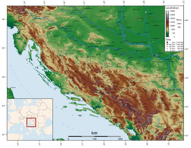
Deutsch: Topographie des Dinarischen Gebirges
English: Topography of the Dinaric Alps
Български: Динарски планини
Čeština: Dinárské hory
Español: Alpes Dináricos
Français : Alpes dinariques
Frysk: Dinaryske Alpen
Galego: Alpes Dináricos
עברית: האלפים הדינרים
Hrvatski: Dinaridi
Magyar: Dinári-hegység
Italiano: Alpi Dinariche
Lietuvių: Dinarų kalnynas
Nederlands: Dinarische Alpen
Norsk nynorsk: Dei dinariske Alpane
Norsk bokmål: De dinariske alper
Polski: Góry Dynarskie
Português: Alpes Dináricos
Română: Alpii Dinarici
Русский: Динарские Альпы
Slovenščina: Dinarsko gorstvo
Shqip: Alpet Dinarite
Türkçe: Dinar Alpleri
Українська: Дінарські Альпи |
| Datum | |
| Boarne |
self-made with GMT using mainly SRTM30-Data. Missing data was completed using the GLOBE dataset. Edited with Inkscape. |
| Auteur | FelixReimann |
The map has been created with the Generic Mapping Tools: https://www.generic-mapping-tools.org/ using one or more of these public-domain datasets for the relief:
|

|
Der wurdt tastimming jûn ta kopiearjen, fersprieden en/of wizigjen fan dit dokumint ûnder de betinksten fan de GNU-lisinsje foar iepen dokumintaasje, ferzje 1.2, as eltse lettere ferzje útjûn troch de Free Software Foundation; sûnder Ynfariante Seksjes, sûnder Omkaftteksten foar de Foarkante en sûnder Omkaftteksten foar de Efterkante. In kopy fan de lisinsje is opnaam yn de seksje "Text of the GNU Free Documentation License". |
| This file is licensed under the Creative Commons Attribution-Share Alike 3.0 Unported license. | ||
| ||
| This licensing tag was added to this file as part of the GFDL licensing update. |
You want mountains or citys added to the map? Just tell me coordinates and names! FelixReimann 19:07, 19 April 2007 (UTC)
- If you need this map in another language, just give me the translations and I will make the rest. FelixReimann 11:37, 5 July 2007 (UTC)
Triemskiednis
Klik op in datum/tiid om it bestân te besjen sa't it op dat stuit wie.
| Datum/Tiid | Miniatuer | ôfmjittings | Meidogger | Opmerking | |
|---|---|---|---|---|---|
| lêste | 23 sep 2011, 18.16 | | 2.900 × 2.250 (7,61 MB) | HylgeriaK | color/saturation |
| 18 nov 2007, 14.59 |  | 2.900 × 2.250 (7,74 MB) | FelixReimann | countries and borders added, some serbian cities added | |
| 17 nov 2007, 01.23 |  | 2.900 × 2.250 (7,66 MB) | FelixReimann | serbian cities and some mountains added | |
| 8 aug 2007, 13.49 |  | 2.900 × 2.250 (7,62 MB) | FelixReimann | cities added. source: http://www.world-gazetteer.com/ | |
| 13 mai 2007, 16.35 |  | 3.306 × 2.339 (7,65 MB) | FelixReimann | cities added | |
| 20 apr 2007, 11.58 |  | 2.839 × 2.209 (7,43 MB) | FelixReimann | Höhenskala und Koordinaten hinzugefügt | |
| 19 apr 2007, 21.01 |  | 2.680 × 2.046 (7,38 MB) | FelixReimann | {{Information |Description=''de:'' Topographie des Dinarischen Gebirges<br/>''en:'' Topography of the Dinaric Alps |Source=self-made with GMT and Inkscape |Date=19.04.2007 |Author= ~~~ |other_versions= }} Category:Maps of mountains {{GFDL-GMT}} |
Bestânsgebrûk
De neikommende side brûkt dit bestân:
Globaal bestânsgebrûk
De neikommende oare wiki's brûke dit bestân:
- Gebrûk op af.wikipedia.org
- Gebrûk op ar.wikipedia.org
- Gebrûk op bg.wikipedia.org
- Gebrûk op cs.wikipedia.org
- Gebrûk op cy.wikipedia.org
- Gebrûk op de.wikipedia.org
- Gebrûk op diq.wikipedia.org
- Gebrûk op el.wikipedia.org
- Gebrûk op en.wikipedia.org
- Gebrûk op eo.wikipedia.org
- Gebrûk op es.wikipedia.org
- Gebrûk op et.wikipedia.org
- Gebrûk op fa.wikipedia.org
- Gebrûk op fi.wikipedia.org
- Gebrûk op fr.wikipedia.org
- Gebrûk op he.wikipedia.org
- Gebrûk op hr.wikipedia.org
- Gebrûk op hu.wikipedia.org
- Gebrûk op id.wikipedia.org
- Gebrûk op ja.wikipedia.org
- Gebrûk op ko.wikipedia.org
- Gebrûk op ky.wikipedia.org
- Gebrûk op lt.wikipedia.org
- Gebrûk op nl.wikipedia.org
- Gebrûk op nn.wikipedia.org
- Gebrûk op no.wikipedia.org
- Gebrûk op pl.wikipedia.org
- Gebrûk op pl.wikivoyage.org
- Gebrûk op pl.wiktionary.org
- Gebrûk op pnb.wikipedia.org
- Gebrûk op ru.wikipedia.org
- Gebrûk op sh.wikipedia.org
- Gebrûk op sk.wikipedia.org
- Gebrûk op sq.wikipedia.org
- Gebrûk op sr.wikipedia.org
- Gebrûk op sv.wikipedia.org
- Gebrûk op tr.wikipedia.org
- Gebrûk op uk.wikipedia.org
- Gebrûk op vi.wikipedia.org
- Gebrûk op vls.wikipedia.org
- Gebrûk op www.wikidata.org
Mear globaal gebrûk fan dit bestân besjen.