
Ofbyld:Crete integrated map-en.svg

Size of this PNG preview of this SVG file: 800 × 378 piksels. Oare resolúsjes: 320 × 151 piksels | 640 × 302 piksels | 1.024 × 484 piksels | 1.280 × 604 piksels | 2.560 × 1.209 piksels | 900 × 425 piksels.
Oarspronklik bestân (SVG-bestân, nominaal 900 × 425 pixels, bestânsgrutte: 265 KB)
Gearfetting
| Camera location | | View this and other nearby images on: OpenStreetMap |
|---|
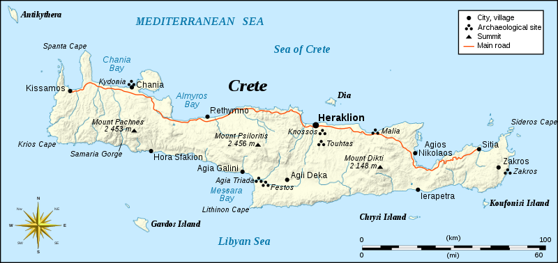
| Beskriuwing | Integrated map of Crete island, Greece | ||
| Datum | |||
| Boarne |
Own work, based on Image:Crete_topographic_map-fr.svg (modified and translated) created by myself ; Compass rose : Image:Brújula.svg (modified) created by Serg!o under GFDL |
||
| Auteur | Eric Gaba (Sting) | ||
| Tastimming (Reusing this file) |
|
||
| Oare ferzjes |
[]
|


|
This SVG file contains embedded text that can be translated into your language, using any capable SVG editor, text editor or the SVG Translate tool. For more information see: About translating SVG files. |
Lisinsje
I, the copyright holder of this work, hereby publish it under the following licenses:

|
Der wurdt tastimming jûn ta kopiearjen, fersprieden en/of wizigjen fan dit dokumint ûnder de betinksten fan de GNU-lisinsje foar iepen dokumintaasje, ferzje 1.2, as eltse lettere ferzje útjûn troch de Free Software Foundation; sûnder Ynfariante Seksjes, sûnder Omkaftteksten foar de Foarkante en sûnder Omkaftteksten foar de Efterkante. In kopy fan de lisinsje is opnaam yn de seksje "Text of the GNU Free Documentation License". |
This file is licensed under the Creative Commons Attribution-Share Alike 4.0 International, 3.0 Unported, 2.5 Generic, 2.0 Generic and 1.0 Generic license.
- Fiel jo frij:
- te dielen – it wurk te kopiearjen, fersprieden en út te stjoeren
- te fermingen – it wurk oan te passen
- Under de neikommende betingsten:
- Nammefermelding – You must give appropriate credit, provide a link to the license, and indicate if changes were made. You may do so in any reasonable manner, but not in any way that suggests the licensor endorses you or your use.
- Lyk diele – If you remix, transform, or build upon the material, you must distribute your contributions under the same or compatible license as the original.
You may select the license of your choice.
Triemskiednis
Klik op in datum/tiid om it bestân te besjen sa't it op dat stuit wie.
| Datum/Tiid | Miniatuer | ôfmjittings | Meidogger | Opmerking | |
|---|---|---|---|---|---|
| lêste | 6 sep 2008, 22.16 | | 900 × 425 (265 KB) | Sting | New standard colors |
| 4 des 2007, 02.54 |  | 900 × 425 (278 KB) | Sting | Oops ! | |
| 4 des 2007, 02.53 |  | 900 × 425 (79 KB) | Sting | {{Location|35|20|00|N|25|00|00|E|scale:2000000}} <br/> {{Information |Description=Integrated map of Crete island, Greece |Source=Own work, based on Image:Crete_topographic_map-fr.svg (modified and translated) created by m |
Bestânsgebrûk
De neikommende 2 siden brûke dit bestân:
Globaal bestânsgebrûk
De neikommende oare wiki's brûke dit bestân:
- Gebrûk op de.wikipedia.org
- Gebrûk op en.wikipedia.org
- Gebrûk op fa.wikipedia.org
- Gebrûk op gl.wikipedia.org
- Gebrûk op hr.wikipedia.org
- Gebrûk op ja.wikipedia.org
- Gebrûk op rue.wikipedia.org
- Gebrûk op ru.wikipedia.org
- Gebrûk op simple.wikipedia.org
- Gebrûk op sk.wikipedia.org
- Gebrûk op sl.wikipedia.org
- Gebrûk op stq.wikipedia.org
- Gebrûk op sv.wikipedia.org
- Gebrûk op th.wikipedia.org
- Gebrûk op vi.wikipedia.org
- Gebrûk op zh.wikipedia.org