
Ofbyld:Connecticut River Map.png
Grutte fan dit proefbyld: 448 × 600 piksels. Oare resolúsjes: 179 × 240 piksels | 578 × 774 piksels.
Oarspronklik bestân (578 × 774 pixels, bestânsgrutte: 58 KB, MIME-type: image/png)
Gearfetting
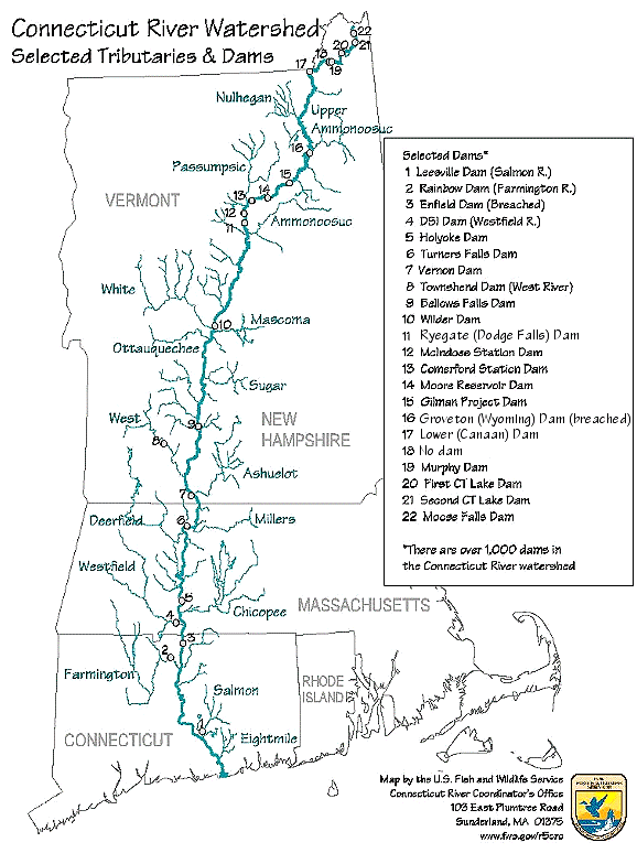
| Beskriuwing | Map of the Connecticut River, New England, USA. This map was prepared by the United States Fish and Wildlife Service, and as a product of the United States Government is in the public domain and not subject to copyright restrictions. | |||
| Boarne | Originally from en.wikipedia; description page is/was here. Original uploader was Daderot at Ingelsk Wikipedy | |||
| Auteur | USGov | |||
| Tastimming (Reusing this file) |
|


|
This transport map image could be re-created using vector graphics as an SVG file. This has several advantages; see Commons:Media for cleanup for more information. If an SVG form of this image is available, please upload it and afterwards replace this template with
{{vector version available|new image name}}.
It is recommended to name the SVG file “Connecticut River Map.svg”—then the template Vector version available (or Vva) does not need the new image name parameter. |
Original upload log
| Datum/Tiid | Ofmjittings | Meidogger | Opmerking |
|---|---|---|---|
| 6 jannewaris 2008, 16:02:00 | 580 × 778 (61343 bytes) | Gridge (oerlis · bydragen) | {{Information |Description=Map of the Connecticut River, New England, USA. This map was prepared by the United States Fish and Wildlife Service, and as a product of the United States Government is in the public domain and not subject to copyright restrict |
Triemskiednis
Klik op in datum/tiid om it bestân te besjen sa't it op dat stuit wie.
| Datum/Tiid | Miniatuer | ôfmjittings | Meidogger | Opmerking | |
|---|---|---|---|---|---|
| lêste | 10 mrt 2024, 10.26 | | 578 × 774 (58 KB) | Lojwe | Cropped < 1 % horizontally, 1 % vertically using CropTool with precise mode. |
| 25 nov 2014, 06.45 |  | 580 × 778 (74 KB) | GifTagger | Bot: Converting file to superior PNG file. (Source: Connecticut_River_Map.gif). This GIF was problematic due to non-greyscale color table. |
Bestânsgebrûk
De neikommende side brûkt dit bestân:
Globaal bestânsgebrûk
De neikommende oare wiki's brûke dit bestân:
- Gebrûk op bg.wikipedia.org
- Gebrûk op cs.wikipedia.org
- Gebrûk op da.wikipedia.org
- Gebrûk op de.wikipedia.org
- Gebrûk op en.wikipedia.org
- Gebrûk op es.wikipedia.org
- Gebrûk op fi.wikipedia.org
- Gebrûk op fr.wikipedia.org
- Gebrûk op he.wikipedia.org
- Gebrûk op incubator.wikimedia.org
- Gebrûk op it.wikipedia.org
- Gebrûk op ja.wikipedia.org
- Gebrûk op nl.wikipedia.org
- Gebrûk op pt.wikipedia.org
- Gebrûk op ru.wikipedia.org
- Gebrûk op simple.wikipedia.org
- Gebrûk op sv.wikipedia.org
- Gebrûk op sw.wikipedia.org
- Gebrûk op ta.wikipedia.org
- Gebrûk op th.wikipedia.org
- Gebrûk op www.wikidata.org
- Gebrûk op zh.wikipedia.org