
Ofbyld:CheyenneCourseWatershed1.png

Grutte fan dit proefbyld: 800 × 557 piksels. Oare resolúsjes: 320 × 223 piksels | 640 × 446 piksels | 814 × 567 piksels.
Oarspronklik bestân (814 × 567 pixels, bestânsgrutte: 43 KB, MIME-type: image/png)
Gearfetting
| Beskriuwing |
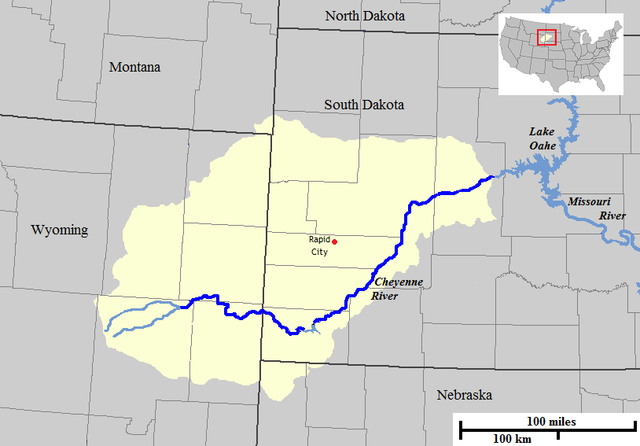
English: Map of the course and watershed of the Cheyenne River in the United States. |
| Datum | |
| Boarne | Base map used was taken from the National Atlas, remaining work was done by the uploader. Drainage basin maps used as a reference were from this site from the United States Geological Survey. |
| Auteur | Jon Platek |
Lisinsje
| I, the copyright holder of this work, release this work into the public domain. This applies worldwide. In some countries this may not be legally possible; if so: I grant anyone the right to use this work for any purpose, without any conditions, unless such conditions are required by law. |
Triemskiednis
Klik op in datum/tiid om it bestân te besjen sa't it op dat stuit wie.
| Datum/Tiid | Miniatuer | ôfmjittings | Meidogger | Opmerking | |
|---|---|---|---|---|---|
| lêste | 1 feb 2009, 10.09 | | 814 × 567 (43 KB) | AlexiusHoratius~commonswiki | {{Information |Description={{en|1=Map of the course and watershed of the Cheyenne River in the United States. }} |Source=Base map used was taken from the [http://www.nationalatlas.gov/natlas/Natlasstart.asp National Atlas], remaining work was done by the |
Bestânsgebrûk
De neikommende side brûkt dit bestân:
Globaal bestânsgebrûk
De neikommende oare wiki's brûke dit bestân:
- Gebrûk op bg.wikipedia.org
- Gebrûk op da.wikipedia.org
- Gebrûk op de.wikipedia.org
- Gebrûk op en.wikipedia.org
- Gebrûk op es.wikipedia.org
- Gebrûk op fr.wikipedia.org
- Gebrûk op lt.wikipedia.org
- Gebrûk op no.wikipedia.org
- Gebrûk op pt.wikipedia.org
- Gebrûk op ru.wikipedia.org
- Gebrûk op sv.wikipedia.org
- Gebrûk op www.wikidata.org
- Gebrûk op xmf.wikipedia.org
- Gebrûk op zh.wikipedia.org