
Ofbyld:Carthaginianempire.PNG

Grutte fan dit proefbyld: 639 × 600 piksels. Oare resolúsjes: 256 × 240 piksels | 511 × 480 piksels | 818 × 768 piksels | 1.091 × 1.024 piksels | 2.424 × 2.276 piksels.
Oarspronklik bestân (2.424 × 2.276 pixels, bestânsgrutte: 65 KB, MIME-type: image/png)

|
This military map image could be re-created using vector graphics as an SVG file. This has several advantages; see Commons:Media for cleanup for more information. If an SVG form of this image is available, please upload it and afterwards replace this template with
{{vector version available|new image name}}.
It is recommended to name the SVG file “Carthaginianempire.svg”—then the template Vector version available (or Vva) does not need the new image name parameter. |
| Beskriuwing |
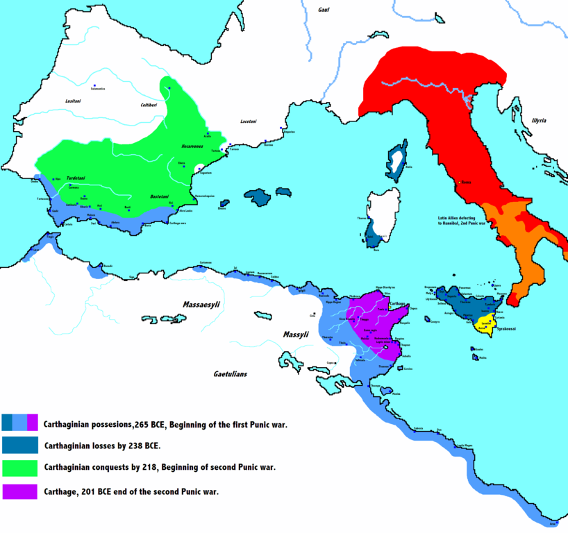
English: Carthaginian empire through the Punic wars |
| Datum |
15 july 2008 (original upload date) |
| Boarne | Eigen wurk (Original text: I created this work entirely by myself.) |
| Auteur | Javierfv1212 (talk) |
Lisinsje
| This work has been released into the public domain by its author, Javierfv1212 at Ingelsk Wikipedy. This applies worldwide. In some countries this may not be legally possible; if so: Javierfv1212 grants anyone the right to use this work for any purpose, without any conditions, unless such conditions are required by law. |
Original upload log
The original description page was here. All following user names refer to en.wikipedia.
- 2014-09-19 17:06 Daygum 2424×2276× (96261 bytes) True expansion of Chartage
- 2008-07-15 13:08 Javierfv1212 2424×2276× (221770 bytes)
- 2008-07-13 06:36 Javierfv1212 2424×2276× (221006 bytes) {{Information |Description=Carthaginian empire through the Punic wars |Source=I created this work entirely by myself. |Date=July 13, 08. |Author=~~~ |other_versions= }}
Triemskiednis
Klik op in datum/tiid om it bestân te besjen sa't it op dat stuit wie.
| Datum/Tiid | Miniatuer | ôfmjittings | Meidogger | Opmerking | |
|---|---|---|---|---|---|
| lêste | 8 mai 2020, 15.01 | | 2.424 × 2.276 (65 KB) | German0706 | Size optimized with ECT (Efficient-Compression-Tool)and pingo (css-ig.net) |
| 11 des 2014, 19.04 |  | 2.424 × 2.276 (94 KB) | OgreBot | (BOT): Uploading old version of file from en.wikipedia; originally uploaded on 2014-09-19 17:06:29 by Daygum | |
| 11 des 2014, 19.04 |  | 2.424 × 2.276 (217 KB) | OgreBot | (BOT): Uploading old version of file from en.wikipedia; originally uploaded on 2008-07-15 13:08:27 by Javierfv1212 | |
| 4 nov 2011, 16.46 |  | 639 × 600 (176 KB) | Javierfv1212 | Reverted to version as of 14:22, 27 November 2008 | |
| 4 nov 2011, 16.03 |  | 1.583 × 869 (365 KB) | Javierfv1212 | I completely redid the map, it's better aesthetically and also more accurate. Now includes more accurate Carthaginian holdings in Spain, cities and landmarks in Italy and expanded eastwards to Greece. Sources: Cambridge Ancient History Vol 8. Rome & the M | |
| 27 nov 2008, 16.22 |  | 639 × 600 (176 KB) | Dorieo | {{Information |Description={{en|Carthaginian empire through the Punic wars}} |Source=Transferred from [http://en.wikipedia.org en.wikipedia]; transfer was stated to be made by User:Dorieo.<br/> (Original text : ''I created this work entirely by myself |
Bestânsgebrûk
De neikommende side brûkt dit bestân:
Globaal bestânsgebrûk
De neikommende oare wiki's brûke dit bestân:
- Gebrûk op arz.wikipedia.org
- Gebrûk op ast.wikipedia.org
- Gebrûk op az.wikipedia.org
- Gebrûk op bg.wikipedia.org
- Gebrûk op ca.wikipedia.org
- Gebrûk op cs.wikipedia.org
- Gebrûk op da.wikipedia.org
- Gebrûk op el.wikipedia.org
- Gebrûk op en.wikipedia.org
- Gebrûk op es.wikibooks.org
- Gebrûk op et.wikipedia.org
- Gebrûk op eu.wikipedia.org
- Gebrûk op fr.wikipedia.org
- Gebrûk op ha.wikipedia.org
- Gebrûk op he.wikipedia.org
- Gebrûk op hu.wikipedia.org
- Gebrûk op hy.wikipedia.org
- Gebrûk op is.wikipedia.org
- Gebrûk op ja.wikipedia.org
- Gebrûk op ka.wikipedia.org
- Gebrûk op ko.wikipedia.org
- Gebrûk op la.wikipedia.org
- Gebrûk op lfn.wikipedia.org
- Gebrûk op ml.wikipedia.org
Mear globaal gebrûk fan dit bestân besjen.