
Ofbyld:Carte Lewis-Clark Expedition-en.png

Grutte fan dit proefbyld: 800 × 499 piksels. Oare resolúsjes: 320 × 200 piksels | 640 × 400 piksels | 849 × 530 piksels.
Oarspronklik bestân (849 × 530 pixels, bestânsgrutte: 193 KB, MIME-type: image/png)
Gearfetting
| Beskriuwing |
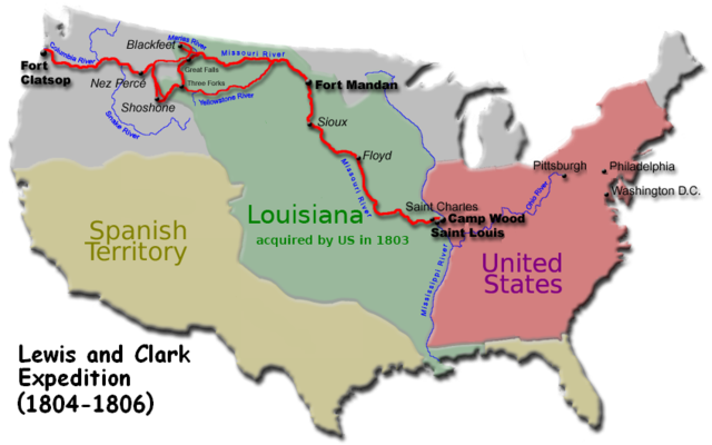
English: Route of the Lewis and Clark Expedition |
| Datum | |
| Boarne | EncMstr modified File:Carte Lewis-Clark Expedition.png to translate text to English. The French version was derived from File:Karte Lewis-und-Clark-Expedition.png |
| Auteur | user:EncMstr, User:Urban, de:Benutzer:Pandat |
| Oare ferzjes | french File:Carte Lewis-Clark Expedition.png, german File:Karte Lewis-und-Clark-Expedition.png & File:Karte Lewis-und-Clark-Expedition.jpg, english File:Carte Lewis and Clark Expedition.png |

|
This historical map image could be re-created using vector graphics as an SVG file. This has several advantages; see Commons:Media for cleanup for more information. If an SVG form of this image is available, please upload it and afterwards replace this template with
{{vector version available|new image name}}.
It is recommended to name the SVG file “Carte Lewis-Clark Expedition-en.svg”—then the template Vector version available (or Vva) does not need the new image name parameter. |
Lisinsje
I, the copyright holder of this work, hereby publish it under the following licenses:

|
Der wurdt tastimming jûn ta kopiearjen, fersprieden en/of wizigjen fan dit dokumint ûnder de betinksten fan de GNU-lisinsje foar iepen dokumintaasje, ferzje 1.2, as eltse lettere ferzje útjûn troch de Free Software Foundation; sûnder Ynfariante Seksjes, sûnder Omkaftteksten foar de Foarkante en sûnder Omkaftteksten foar de Efterkante. In kopy fan de lisinsje is opnaam yn de seksje "Text of the GNU Free Documentation License". |
This file is licensed under the Creative Commons Attribution-Share Alike 4.0 International, 3.0 Unported, 2.5 Generic, 2.0 Generic and 1.0 Generic license.
- Fiel jo frij:
- te dielen – it wurk te kopiearjen, fersprieden en út te stjoeren
- te fermingen – it wurk oan te passen
- Under de neikommende betingsten:
- Nammefermelding – You must give appropriate credit, provide a link to the license, and indicate if changes were made. You may do so in any reasonable manner, but not in any way that suggests the licensor endorses you or your use.
- Lyk diele – If you remix, transform, or build upon the material, you must distribute your contributions under the same or compatible license as the original.
You may select the license of your choice.
Triemskiednis
Klik op in datum/tiid om it bestân te besjen sa't it op dat stuit wie.
| Datum/Tiid | Miniatuer | ôfmjittings | Meidogger | Opmerking | |
|---|---|---|---|---|---|
| lêste | 7 des 2007, 09.43 | | 849 × 530 (193 KB) | EncMstr | {{Information |Description=Route of the w:Lewis and Clark Expedition |Source=EncMstr modified image:Carte Lewis-Clark Expedition.png to translate text to English. The French version was derived from http://de.wikipedia.org/wiki/Bild:Karte_Lewis |
Bestânsgebrûk
De neikommende side brûkt dit bestân:
Globaal bestânsgebrûk
De neikommende oare wiki's brûke dit bestân:
- Gebrûk op af.wikipedia.org
- Gebrûk op bg.wikipedia.org
- Gebrûk op ca.wikipedia.org
- Gebrûk op cs.wikipedia.org
- Gebrûk op cv.wikipedia.org
- Gebrûk op en.wikipedia.org
- Gebrûk op eo.wikipedia.org
- Gebrûk op fi.wikipedia.org
- Gebrûk op he.wikipedia.org
- Gebrûk op hu.wikipedia.org
- Gebrûk op hy.wikipedia.org
- Gebrûk op ja.wikipedia.org
- Gebrûk op ko.wikipedia.org
- Gebrûk op pt.wikipedia.org
- Gebrûk op ru.wikipedia.org
- Gebrûk op simple.wikipedia.org
- Gebrûk op uk.wikipedia.org
- Gebrûk op vi.wikipedia.org