
Ofbyld:Canada provinces 1870-1871.png

Grutte fan dit proefbyld: 694 × 600 piksels. Oare resolúsjes: 278 × 240 piksels | 556 × 480 piksels | 1.000 × 864 piksels.
Oarspronklik bestân (1.000 × 864 pixels, bestânsgrutte: 58 KB, MIME-type: image/png)

|
This historical map image could be re-created using vector graphics as an SVG file. This has several advantages; see Commons:Media for cleanup for more information. If an SVG form of this image is available, please upload it and afterwards replace this template with
{{vector version available|new image name}}.
It is recommended to name the SVG file “Canada provinces 1870-1871.svg”—then the template Vector version available (or Vva) does not need the new image name parameter. |
Gearfetting
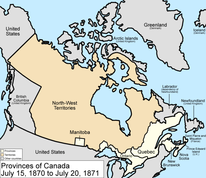
Map of the provinces and territories of Canada as they were from 1870 to 1871. On July 15 1870, Rupert's Land and the North-Western Territory were ceded to Canada, and became the North-West Territories; a small square of this was made into the province of Manitoba. On July 20 1871, British Columbia joined as a province.
Made by User:Golbez.
Lisinsje
I, the copyright holder of this work, hereby publish it under the following licenses:

|
Der wurdt tastimming jûn ta kopiearjen, fersprieden en/of wizigjen fan dit dokumint ûnder de betinksten fan de GNU-lisinsje foar iepen dokumintaasje, ferzje 1.2, as eltse lettere ferzje útjûn troch de Free Software Foundation; sûnder Ynfariante Seksjes, sûnder Omkaftteksten foar de Foarkante en sûnder Omkaftteksten foar de Efterkante. In kopy fan de lisinsje is opnaam yn de seksje "Text of the GNU Free Documentation License". |
| This file is licensed under the Creative Commons Attribution-Share Alike 3.0 Unported license. | ||
| ||
| This licensing tag was added to this file as part of the GFDL licensing update. |
This file is licensed under the Creative Commons Attribution 2.5 Generic license.
- Fiel jo frij:
- te dielen – it wurk te kopiearjen, fersprieden en út te stjoeren
- te fermingen – it wurk oan te passen
- Under de neikommende betingsten:
- Nammefermelding – You must give appropriate credit, provide a link to the license, and indicate if changes were made. You may do so in any reasonable manner, but not in any way that suggests the licensor endorses you or your use.
You may select the license of your choice.
Triemskiednis
Klik op in datum/tiid om it bestân te besjen sa't it op dat stuit wie.
| Datum/Tiid | Miniatuer | ôfmjittings | Meidogger | Opmerking | |
|---|---|---|---|---|---|
| lêste | 14 jul 2009, 19.17 | | 1.000 × 864 (58 KB) | Golbez | New color scheme, other borders |
| 13 mrt 2007, 20.53 |  | 1.000 × 864 (46 KB) | Golbez | Fix date | |
| 7 aug 2006, 11.59 |  | 1.000 × 864 (46 KB) | Golbez | with legend | |
| 18 feb 2006, 04.24 |  | 1.000 × 864 (45 KB) | Golbez | Better version | |
| 14 feb 2006, 01.42 |  | 950 × 725 (26 KB) | Golbez | Map of the provinces of Canada as they were from 1870 to 1871. On July 15 1870, Rupert's Land and were ceded to Canada, and became the North-West Territories; a small square of this was made into the province of Manitoba. On July 20 1871, British Columbia |
Bestânsgebrûk
De neikommende side brûkt dit bestân:
Globaal bestânsgebrûk
De neikommende oare wiki's brûke dit bestân:
- Gebrûk op cs.wikipedia.org
- Gebrûk op de.wikipedia.org
- Gebrûk op en.wikipedia.org
- Gebrûk op es.wikipedia.org
- Gebrûk op fi.wikipedia.org
- Gebrûk op fr.wikipedia.org
- Gebrûk op fr.wiktionary.org
- Gebrûk op he.wikipedia.org
- Gebrûk op hy.wikipedia.org
- Gebrûk op it.wikipedia.org
- Gebrûk op lt.wikipedia.org
- Gebrûk op no.wikipedia.org
- Gebrûk op pt.wikipedia.org
- Gebrûk op ru.wikipedia.org
- Gebrûk op sh.wikipedia.org
- Gebrûk op sr.wikipedia.org
- Gebrûk op sv.wikipedia.org
- Gebrûk op uk.wikipedia.org
- Gebrûk op vi.wikipedia.org
- Gebrûk op zh.wikipedia.org