
Ofbyld:Burrard-Inlet-map-en.svg

Size of this PNG preview of this SVG file: 800 × 574 piksels. Oare resolúsjes: 320 × 230 piksels | 640 × 460 piksels | 1.024 × 735 piksels | 1.280 × 919 piksels | 2.560 × 1.838 piksels | 1.259 × 904 piksels.
Oarspronklik bestân (SVG-bestân, nominaal 1.259 × 904 pixels, bestânsgrutte: 80 KB)
| Beskriuwing |
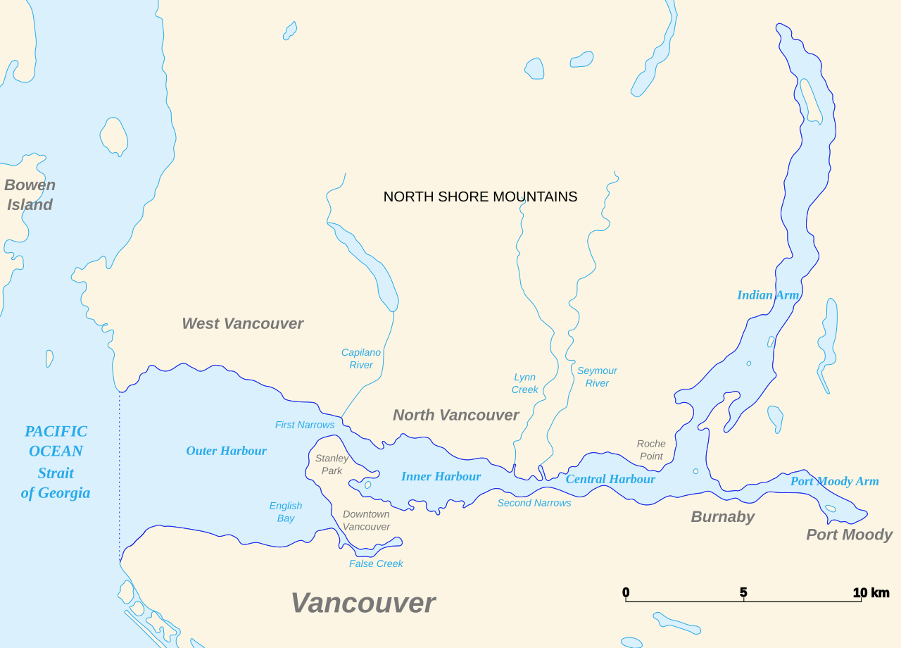
English: Map of Burrard Inlet |
| Datum | (UTC) |
| Boarne | |
| Auteur |
|
| This is a retouched picture, which means that it has been digitally altered from its original version. Modifications: Translated. The original can be viewed here: Baie Burrard carte avec toponymes en francais.svg:
|
I, the copyright holder of this work, hereby publish it under the following licenses:
This file is licensed under the Creative Commons Attribution-Share Alike 3.0 Unported, 2.5 Generic, 2.0 Generic and 1.0 Generic license.
- Fiel jo frij:
- te dielen – it wurk te kopiearjen, fersprieden en út te stjoeren
- te fermingen – it wurk oan te passen
- Under de neikommende betingsten:
- Nammefermelding – You must give appropriate credit, provide a link to the license, and indicate if changes were made. You may do so in any reasonable manner, but not in any way that suggests the licensor endorses you or your use.
- Lyk diele – If you remix, transform, or build upon the material, you must distribute your contributions under the same or compatible license as the original.

|
Der wurdt tastimming jûn ta kopiearjen, fersprieden en/of wizigjen fan dit dokumint ûnder de betinksten fan de GNU-lisinsje foar iepen dokumintaasje, ferzje 1.2, as eltse lettere ferzje útjûn troch de Free Software Foundation; sûnder Ynfariante Seksjes, sûnder Omkaftteksten foar de Foarkante en sûnder Omkaftteksten foar de Efterkante. In kopy fan de lisinsje is opnaam yn de seksje "Text of the GNU Free Documentation License". |
You may select the license of your choice.
Original upload log
This image is a derivative work of the following images:
- File:Baie_Burrard_carte_avec_toponymes_en_francais.svg licensed with Cc-by-sa-3.0,2.5,2.0,1.0, GFDL
- 2007-11-22T22:48:59Z Arct 1273x918 (94000 Bytes)
- 2007-11-21T22:05:09Z Arct 1273x918 (71725 Bytes) Carte de la baie Burrard au Nord de Vancouver en Colombie-Britannique au Canada, avec quelques toponymes dont certains traduits en français. Données du contour des rivages obtenues sur le [ftp://e0srp01u.ecs.nasa.gov/srtm/
- 2007-11-21T01:20:20Z Arct 1273x918 (71742 Bytes)
- 2007-11-21T01:19:09Z Arct 1273x918 (68835 Bytes)
- 2007-11-20T23:52:27Z Arct 1273x918 (66917 Bytes) {{Information |Description=Carte de la baie Burrard au Nord de Vancouver en Colombie-Britannique au Canada, avec quelques toponymes dont certains traduits en français. Données du contour des rivages obtenues sur le [ftp://e
Uploaded with derivativeFX
Triemskiednis
Klik op in datum/tiid om it bestân te besjen sa't it op dat stuit wie.
| Datum/Tiid | Miniatuer | ôfmjittings | Meidogger | Opmerking | |
|---|---|---|---|---|---|
| lêste | 12 mrt 2011, 20.26 | | 1.259 × 904 (80 KB) | Themightyquill | oops, restore opacity |
| 12 mrt 2011, 20.26 |  | 1.259 × 904 (80 KB) | Themightyquill | trim borders | |
| 12 mrt 2011, 20.21 |  | 1.273 × 918 (91 KB) | Themightyquill | {{Information |Description={{en|Map of Burrard Inslet}} |Source=*File:Baie_Burrard_carte_avec_toponymes_en_francais.svg |Date=2011-03-12 18:19 (UTC) |Author=*File:Baie_Burrard_carte_avec_toponymes_en_francais.svg: Arct *derivativ |
Bestânsgebrûk
De neikommende side brûkt dit bestân:
Globaal bestânsgebrûk
De neikommende oare wiki's brûke dit bestân:
- Gebrûk op en.wikipedia.org
- Gebrûk op fa.wikipedia.org