
Ofbyld:Bronx Highlight New York City Map Julius Schorzman.png
Grutte fan dit proefbyld: 616 × 600 piksels. Oare resolúsjes: 247 × 240 piksels | 493 × 480 piksels | 789 × 768 piksels | 1.052 × 1.024 piksels | 2.104 × 2.048 piksels | 2.652 × 2.582 piksels.
Oarspronklik bestân (2.652 × 2.582 pixels, bestânsgrutte: 4,67 MB, MIME-type: image/png)
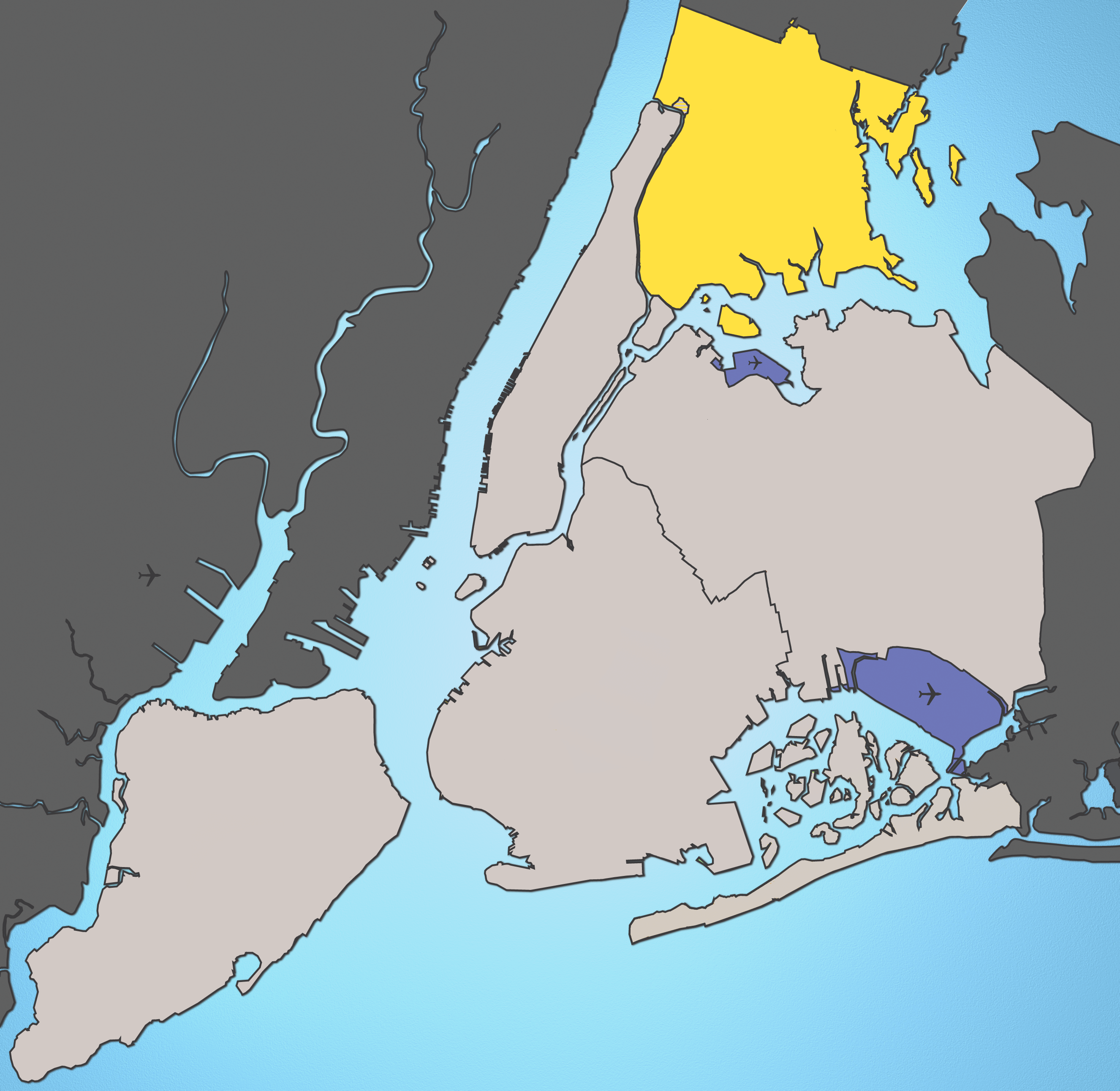
A map of New York City with the Bronx highlighted.

|
This map image could be re-created using vector graphics as an SVG file. This has several advantages; see Commons:Media for cleanup for more information. If an SVG form of this image is available, please upload it and afterwards replace this template with
{{vector version available|new image name}}.
It is recommended to name the SVG file “Bronx Highlight New York City Map Julius Schorzman.svg”—then the template Vector version available (or Vva) does not need the new image name parameter. |
Notes:
- Marble Hill is shown as part Manhattan, part Bronx. See Wikipedia:Marble Hill, Manhattan, New York for more information.
- Several islands (such as Rikers Island) are highlighted since they are governmentally a part of the Bronx
Source: I created this image using various maps and images.
Attribution: Julius Schorzman
This file is licensed under the Creative Commons Attribution-Share Alike 2.5 Generic license.
- Fiel jo frij:
- te dielen – it wurk te kopiearjen, fersprieden en út te stjoeren
- te fermingen – it wurk oan te passen
- Under de neikommende betingsten:
- Nammefermelding – You must give appropriate credit, provide a link to the license, and indicate if changes were made. You may do so in any reasonable manner, but not in any way that suggests the licensor endorses you or your use.
- Lyk diele – If you remix, transform, or build upon the material, you must distribute your contributions under the same or compatible license as the original.
\
Triemskiednis
Klik op in datum/tiid om it bestân te besjen sa't it op dat stuit wie.
| Datum/Tiid | Miniatuer | ôfmjittings | Meidogger | Opmerking | |
|---|---|---|---|---|---|
| lêste | 19 aug 2005, 04.01 | | 2.652 × 2.582 (4,67 MB) | Quasipalm | A map of New York City with the Bronx highlighted. Notes: # '''Marble Hill''' is shown as part Manhattan, part Bronx. See wiki:Marble Hill for more information. # Several islands (such as '''Rikers Island''') are highlighted since they are governmen |
Bestânsgebrûk
De neikommende side brûkt dit bestân:
Globaal bestânsgebrûk
De neikommende oare wiki's brûke dit bestân:
- Gebrûk op bg.wikipedia.org
- Gebrûk op bs.wikipedia.org
- Gebrûk op de.wikipedia.org
- Gebrûk op en.wikipedia.org
- Gebrûk op en.wikinews.org
- Gebrûk op fa.wikipedia.org
- Gebrûk op frr.wikipedia.org
- Gebrûk op fr.wikipedia.org
- Gebrûk op fr.wikinews.org
- Gebrûk op fr.wiktionary.org
- Gebrûk op he.wikipedia.org
- Gebrûk op hr.wikipedia.org
- Gebrûk op hu.wikipedia.org
- Gebrûk op is.wikipedia.org
- Gebrûk op ja.wikipedia.org
- Gebrûk op ka.wikipedia.org
- Gebrûk op ko.wikipedia.org
- Gebrûk op lt.wikipedia.org
- Gebrûk op lv.wikipedia.org
- Gebrûk op mk.wikipedia.org
- Gebrûk op mr.wikipedia.org
- Gebrûk op pl.wikipedia.org
- Gebrûk op pt.wikipedia.org
- Gebrûk op ru.wikipedia.org
- Gebrûk op sh.wikipedia.org
- Gebrûk op sk.wikipedia.org
- Gebrûk op sr.wikipedia.org
- Gebrûk op sw.wikipedia.org
- Gebrûk op th.wikipedia.org
- Gebrûk op tl.wikipedia.org
- Gebrûk op uk.wikipedia.org
- Gebrûk op xmf.wikipedia.org
- Gebrûk op zh-min-nan.wikipedia.org