
Ofbyld:Boulder Clay Cliffs - geograph.org.uk - 250110.jpg
Gjin hegere resolúsje beskikber.
Boulder_Clay_Cliffs_-_geograph.org.uk_-_250110.jpg (640 × 480 pixels, bestânsgrutte: 92 KB, MIME-type: image/jpeg)
Gearfetting
| Beskriuwing |
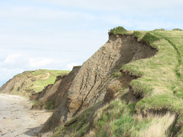
English: Boulder Clay Cliffs This photo was taken in the northern part of the square and shows clearly the friable nature of the boulder clay cliffs. In the distance are the seaward ramparts of Dinas Dinlle Iron Age Fort SH4356. |
| Datum | |
| Boarne | From geograph.org.uk |
| Auteur | Eric Jones |
| Nammefermelding (required by the license) | Eric Jones / Boulder Clay Cliffs / |
| Camera location | | View this and other nearby images on: OpenStreetMap |
|---|
_heading:22.00&language=fy)
| Object location | | View this and other nearby images on: OpenStreetMap |
|---|
_heading:22.00&language=fy)
Lisinsje

|
This image was taken from the Geograph project collection. See this photograph's page on the Geograph website for the photographer's contact details. The copyright on this image is owned by Eric Jones and is licensed for reuse under the Creative Commons Attribution-ShareAlike 2.0 license.
|
This file is licensed under the Creative Commons Attribution-Share Alike 2.0 Generic license.
Nammefermelding: Eric Jones
- Fiel jo frij:
- te dielen – it wurk te kopiearjen, fersprieden en út te stjoeren
- te fermingen – it wurk oan te passen
- Under de neikommende betingsten:
- Nammefermelding – You must give appropriate credit, provide a link to the license, and indicate if changes were made. You may do so in any reasonable manner, but not in any way that suggests the licensor endorses you or your use.
- Lyk diele – If you remix, transform, or build upon the material, you must distribute your contributions under the same or compatible license as the original.
Triemskiednis
Klik op in datum/tiid om it bestân te besjen sa't it op dat stuit wie.
| Datum/Tiid | Miniatuer | ôfmjittings | Meidogger | Opmerking | |
|---|---|---|---|---|---|
| lêste | 25 aug 2010, 18.39 | | 640 × 480 (92 KB) | GeographBot | == {{int:filedesc}} == {{Information |description={{en|1=Boulder Clay Cliffs This photo was taken in the northern part of the square and shows clearly the friable nature of the boulder clay cliffs. In the distance are the seaward ramparts of Dinas Dinlle |
Bestânsgebrûk
De neikommende side brûkt dit bestân:
Globaal bestânsgebrûk
De neikommende oare wiki's brûke dit bestân:
- Gebrûk op ar.wikipedia.org
- Gebrûk op bn.wikipedia.org
- Gebrûk op en.wikipedia.org
- Gebrûk op fa.wikipedia.org
- Gebrûk op fr.wikipedia.org
- Gebrûk op kw.wikipedia.org
- Gebrûk op nl.wikipedia.org
- Gebrûk op zh.wikipedia.org