
Ofbyld:Bering Sea Location.png
Bering_Sea_Location.png (700 × 375 pixels, bestânsgrutte: 116 KB, MIME-type: image/png)
La bildo estas kopiita de wikipedia:en. La originala priskribo estas:
Gearfetting
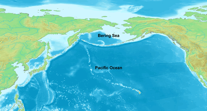
Map showing the Bering Sea and its location in the Pacific Ocean. Created from a composite of two maps on Wikimedia Commons: Image:Topographic90deg N0E90.png Image:Topographic90deg N0W90.png
Lisinsje

|
Der wurdt tastimming jûn ta kopiearjen, fersprieden en/of wizigjen fan dit dokumint ûnder de betinksten fan de GNU-lisinsje foar iepen dokumintaasje, ferzje 1.2, as eltse lettere ferzje útjûn troch de Free Software Foundation; sûnder Ynfariante Seksjes, sûnder Omkaftteksten foar de Foarkante en sûnder Omkaftteksten foar de Efterkante. In kopy fan de lisinsje is opnaam yn de seksje "Text of the GNU Free Documentation License". |
| This file is licensed under the Creative Commons Attribution-Share Alike 3.0 Unported license. | ||
| ||
| This licensing tag was added to this file as part of the GFDL licensing update. |
| date/time | username | edit summary |
|---|---|---|
| 23:41, 18 December 2005 | en:User:DanMS | (Map showing the Bering Sea and its location in the Pacific Ocean. Created from a composite of two maps on Wikimedia Commons: [http://commons.wikimedia.org/wiki/Image:Topographic90deg_N0E90.png] [http://commons.wikimedia.org/wiki/Image:Topographic90deg_N0W) |
Original upload log
Legend: (cur) = this is the current file, (del) = delete this old version, (rev) = revert to this old version.
Click on date to download the file or see the image uploaded on that date.
- (del) (cur) 23:41, 18 December 2005 . . en:User:DanMS DanMS ( en:User_talk:DanMS Talk) . . 700x375 (114665 bytes) (Map showing the Bering Sea and its location in the Pacific Ocean. Created from a composite of two maps on Wikimedia Commons: Image:Topographic90deg N0E90.png [http://commons.wikimedia.org/wiki/Image:Topographic90deg_N0W)
en:Image:Bering Sea Location.gif
Original upload log
| Datum/Tiid | Ofmjittings | Meidogger | Opmerking |
|---|---|---|---|
| 26 maart 2006, 07:23:19 | 700 × 375 (114665 bytes) | Maksim (oerlis · bydragen) | La bildo estas kopiita de wikipedia:en. La originala priskribo estas: == Summary == Map showing the Bering Sea and its location in the Pacific Ocean. Created from a composite of two maps on Wikimedia Commons: [http://commons.wikimedia.org/wiki/Image:Topo |
Triemskiednis
Klik op in datum/tiid om it bestân te besjen sa't it op dat stuit wie.
| Datum/Tiid | Miniatuer | ôfmjittings | Meidogger | Opmerking | |
|---|---|---|---|---|---|
| lêste | 24 aug 2014, 05.07 | | 700 × 375 (116 KB) | GifTagger | Bot: Converting file to superior PNG file. (Source: Bering_Sea_Location.gif). This GIF was problematic due to non-greyscale color table. |
Bestânsgebrûk
De neikommende side brûkt dit bestân:
Globaal bestânsgebrûk
De neikommende oare wiki's brûke dit bestân:
- Gebrûk op af.wikipedia.org
- Gebrûk op ar.wikipedia.org
- Gebrûk op bn.wikipedia.org
- Gebrûk op bs.wikipedia.org
- Gebrûk op ca.wikipedia.org
- Gebrûk op ceb.wikipedia.org
- Gebrûk op cs.wikipedia.org
- Gebrûk op cv.wikipedia.org
- Gebrûk op cy.wikipedia.org
- Gebrûk op dsb.wikipedia.org
- Gebrûk op el.wikipedia.org
- Gebrûk op en.wikipedia.org
- Gebrûk op eo.wikipedia.org
- Gebrûk op fa.wikipedia.org
- Gebrûk op fr.wiktionary.org
- Gebrûk op hr.wikipedia.org
- Gebrûk op hsb.wikipedia.org
- Gebrûk op hu.wikipedia.org
- Gebrûk op hu.wiktionary.org
- Gebrûk op it.wikipedia.org
- Gebrûk op ka.wikipedia.org
- Gebrûk op kk.wikipedia.org
- Gebrûk op ku.wikipedia.org
- Gebrûk op la.wikipedia.org
- Gebrûk op lt.wikipedia.org
- Gebrûk op mhr.wikipedia.org
- Gebrûk op mk.wikipedia.org
- Gebrûk op mn.wikipedia.org
- Gebrûk op mr.wikipedia.org
- Gebrûk op ms.wikipedia.org
- Gebrûk op nl.wikipedia.org
- Gebrûk op nn.wikipedia.org
- Gebrûk op no.wikipedia.org
- Gebrûk op pa.wikipedia.org
- Gebrûk op pl.wikipedia.org
- Gebrûk op pl.wikiquote.org
- Gebrûk op pt.wikipedia.org
- Gebrûk op pt.wikibooks.org
- Gebrûk op ro.wikipedia.org
- Gebrûk op sh.wikipedia.org
- Gebrûk op simple.wikipedia.org
- Gebrûk op sk.wikipedia.org
- Gebrûk op sl.wikipedia.org
- Gebrûk op sq.wikipedia.org
- Gebrûk op sr.wikipedia.org
- Gebrûk op ta.wikipedia.org
- Gebrûk op th.wikipedia.org
- Gebrûk op tl.wikipedia.org
Mear globaal gebrûk fan dit bestân besjen.