
Ofbyld:Arkansasrivermap.jpg
Gjin hegere resolúsje beskikber.
Arkansasrivermap.jpg (771 × 533 pixels, bestânsgrutte: 259 KB, MIME-type: image/jpeg)
Gearfetting
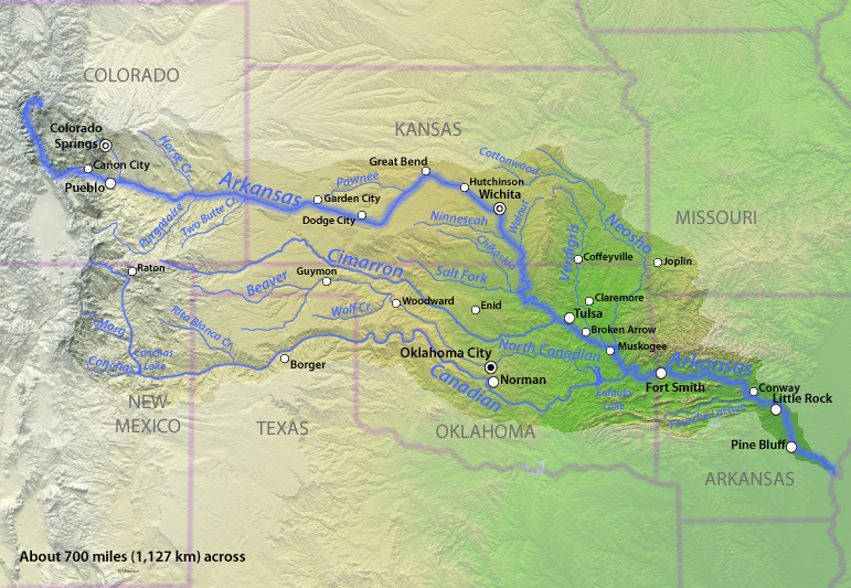
| Beskriuwing |
English: Map of the Arkansas River watershed in the south-central United States. |
| Datum | |
| Boarne | Drawn by myself; shaded relief data from NASA SRTM North America imagery here |
| Auteur | Shannon1 |
Lisinsje
I, the copyright holder of this work, hereby publish it under the following licenses:

|
Der wurdt tastimming jûn ta kopiearjen, fersprieden en/of wizigjen fan dit dokumint ûnder de betinksten fan de GNU-lisinsje foar iepen dokumintaasje, ferzje 1.2, as eltse lettere ferzje útjûn troch de Free Software Foundation; sûnder Ynfariante Seksjes, sûnder Omkaftteksten foar de Foarkante en sûnder Omkaftteksten foar de Efterkante. In kopy fan de lisinsje is opnaam yn de seksje "Text of the GNU Free Documentation License". |
This file is licensed under the Creative Commons Attribution-Share Alike 4.0 International, 3.0 Unported, 2.5 Generic, 2.0 Generic and 1.0 Generic license.
- Fiel jo frij:
- te dielen – it wurk te kopiearjen, fersprieden en út te stjoeren
- te fermingen – it wurk oan te passen
- Under de neikommende betingsten:
- Nammefermelding – You must give appropriate credit, provide a link to the license, and indicate if changes were made. You may do so in any reasonable manner, but not in any way that suggests the licensor endorses you or your use.
- Lyk diele – If you remix, transform, or build upon the material, you must distribute your contributions under the same or compatible license as the original.
You may select the license of your choice.
Triemskiednis
Klik op in datum/tiid om it bestân te besjen sa't it op dat stuit wie.
| Datum/Tiid | Miniatuer | ôfmjittings | Meidogger | Opmerking | |
|---|---|---|---|---|---|
| lêste | 22 nov 2010, 01.07 | | 771 × 533 (259 KB) | Shannon1 | {{Information |Description={{en|1=Map of the Arkansas River watershed in the south-central United States.}} |Source=Drawn by myself; shaded relief data from NASA SRTM North America imagery [http://www2.jpl.nasa.gov/srtm/northAmerica.htm here] |Author=[[Us |
Bestânsgebrûk
Der binne gjin siden dy't dit bestân brûke.
Globaal bestânsgebrûk
De neikommende oare wiki's brûke dit bestân:
- Gebrûk op af.wikipedia.org
- Gebrûk op be-tarask.wikipedia.org