
Ofbyld:Administrative Districts of Germany 1981-2008.svg

Size of this PNG preview of this SVG file: 439 × 599 piksels. Oare resolúsjes: 176 × 240 piksels | 352 × 480 piksels | 563 × 768 piksels | 750 × 1.024 piksels | 1.500 × 2.048 piksels | 1.351 × 1.844 piksels.
Oarspronklik bestân (SVG-bestân, nominaal 1.351 × 1.844 pixels, bestânsgrutte: 1,39 MB)
Gearfetting
| Beskriuwing |
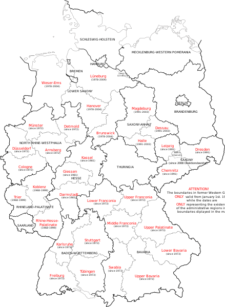
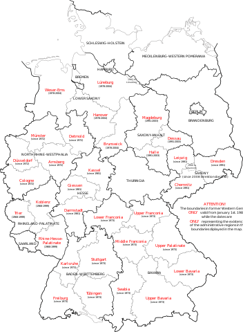
English: Map of Germany showing the boundaries of the Regierungsbezirke for FRG from January 1st 1981 and for Germany till 2008. Also displayed are the former RB of Lower Saxony, Rhineland-Palatinate and Saxony-Anhalt. |
| Datum | |
| Boarne | Own work, map translated from Image:Regierungsbezirke_Deutschlands_1981-2008.svg |
| Auteur | Bennet Schulte |
Lisinsje
I, the copyright holder of this work, hereby publish it under the following licenses:
This file is licensed under the Creative Commons Attribution-Share Alike 3.0 Unported license.
- Fiel jo frij:
- te dielen – it wurk te kopiearjen, fersprieden en út te stjoeren
- te fermingen – it wurk oan te passen
- Under de neikommende betingsten:
- Nammefermelding – You must give appropriate credit, provide a link to the license, and indicate if changes were made. You may do so in any reasonable manner, but not in any way that suggests the licensor endorses you or your use.
- Lyk diele – If you remix, transform, or build upon the material, you must distribute your contributions under the same or compatible license as the original.

|
Der wurdt tastimming jûn ta kopiearjen, fersprieden en/of wizigjen fan dit dokumint ûnder de betinksten fan de GNU-lisinsje foar iepen dokumintaasje, ferzje 1.2, as eltse lettere ferzje útjûn troch de Free Software Foundation; sûnder Ynfariante Seksjes, sûnder Omkaftteksten foar de Foarkante en sûnder Omkaftteksten foar de Efterkante. In kopy fan de lisinsje is opnaam yn de seksje "Text of the GNU Free Documentation License". |
You may select the license of your choice.
Triemskiednis
Klik op in datum/tiid om it bestân te besjen sa't it op dat stuit wie.
| Datum/Tiid | Miniatuer | ôfmjittings | Meidogger | Opmerking | |
|---|---|---|---|---|---|
| lêste | 1 okt 2009, 16.33 | | 1.351 × 1.844 (1,39 MB) | Exec | Neuhaus again |
| 1 okt 2009, 16.29 |  | 1.351 × 1.844 (1,39 MB) | Exec | adding fact of Neuhaus | |
| 30 sep 2009, 15.59 |  | 1.351 × 1.844 (1,39 MB) | Exec | another translation error solved | |
| 30 sep 2009, 15.56 |  | 1.351 × 1.844 (1,39 MB) | Exec | translation error solved | |
| 30 sep 2009, 15.50 |  | 1.351 × 1.844 (1,39 MB) | Exec | {{Information |Description={{en|1=Map of Germany showing the boundaries of the Regierungsbezirke for FRG from January 1st 1981 and for Germany till 2008. Also displayed are the former RB of Lower Saxony, Rhineland-Palatinate and Saxony-Anhalt.}} |Source={ |
Bestânsgebrûk
De neikommende side brûkt dit bestân:
Globaal bestânsgebrûk
De neikommende oare wiki's brûke dit bestân:
- Gebrûk op ca.wikipedia.org
- Gebrûk op en.wikipedia.org
- Gebrûk op et.wikipedia.org
- Gebrûk op fr.wikipedia.org
- Gebrûk op gv.wikipedia.org
- Gebrûk op ia.wikipedia.org
- Gebrûk op ku.wikipedia.org
- Gebrûk op ms.wikipedia.org
- Gebrûk op th.wikipedia.org
- Gebrûk op uk.wikipedia.org
- Gebrûk op www.wikidata.org
- Gebrûk op zh.wikipedia.org