
Ofbyld:Wolin-Topomap.png
Oarspronklik bestân (1.088 × 784 pixels, bestânsgrutte: 439 KB, MIME-type: image/png)
Gearfetting
| Beskriuwing |
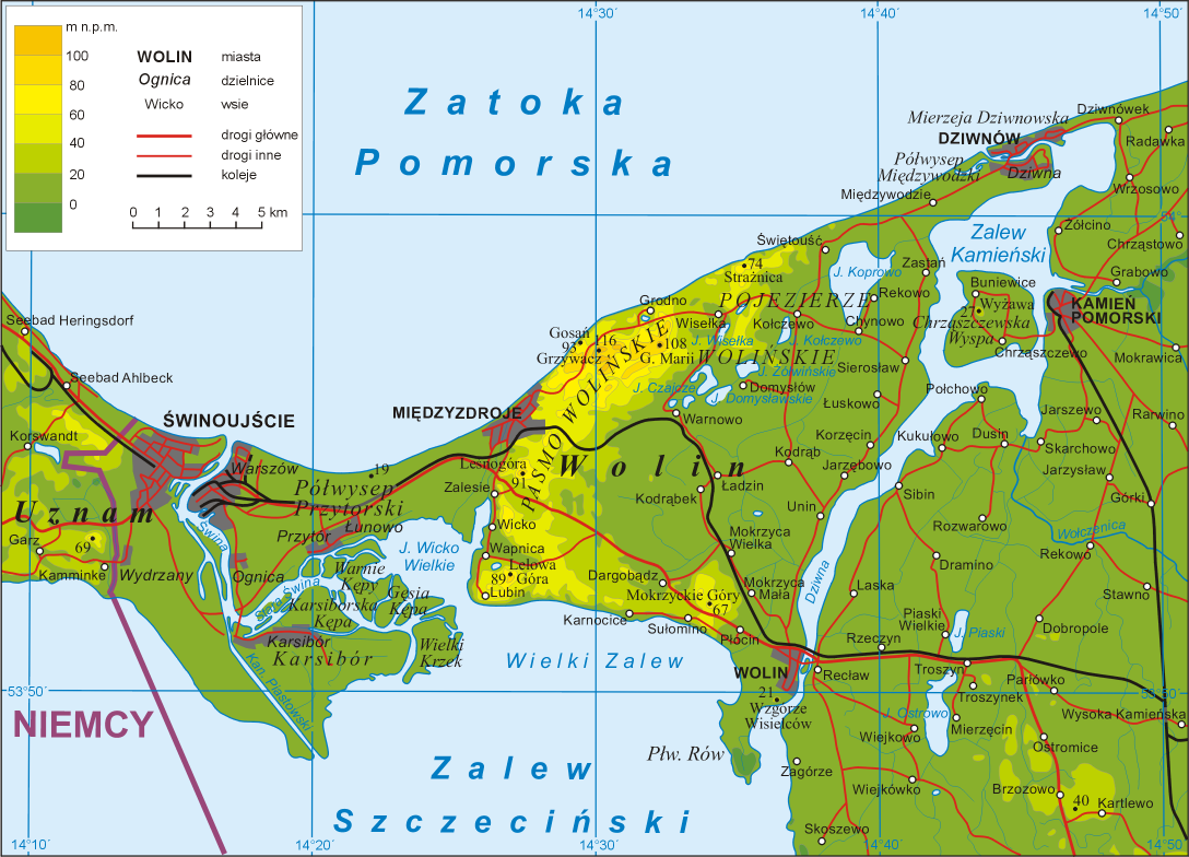
Polski: Mapa topograficzna wyspy Wolin
English: Map of Wolin island, województwo zachodniopomorskie (West Pomeranian Voivodship), Poland. |
| Datum | |
| Boarne | Eigen wurk |
| Auteur | Aotearoa |
Key
in legend:
miasta - towns
dzielnice - town's districts
wsie - villages
drogi główne - main roads
drogi inne - other roads
koleje - railways
Heights in metres
Geographic names:
Zatoka Pomorska - Bay of Pomerania
Zalew Szczeciński - Lagoon of Szczecin
Uznam - Usedom
Niemcy - Germany
Lisinsje

|
Der wurdt tastimming jûn ta kopiearjen, fersprieden en/of wizigjen fan dit dokumint ûnder de betinksten fan de GNU-lisinsje foar iepen dokumintaasje, ferzje 1.2, as eltse lettere ferzje útjûn troch de Free Software Foundation; sûnder Ynfariante Seksjes, sûnder Omkaftteksten foar de Foarkante en sûnder Omkaftteksten foar de Efterkante. In kopy fan de lisinsje is opnaam yn de seksje "Text of the GNU Free Documentation License". |
| This file is licensed under the Creative Commons Attribution-Share Alike 3.0 Unported license. | ||
| ||
| This licensing tag was added to this file as part of the GFDL licensing update. |
|
Triemskiednis
Klik op in datum/tiid om it bestân te besjen sa't it op dat stuit wie.
| Datum/Tiid | Miniatuer | ôfmjittings | Meidogger | Opmerking | |
|---|---|---|---|---|---|
| lêste | 27 apr 2009, 23.03 | | 1.088 × 784 (439 KB) | Aotearoa | Dodanie miejscowości |
| 26 jun 2008, 14.35 |  | 1.088 × 784 (186 KB) | Aotearoa | {{Information |Description= |Source= |Date= |Author= |Permission= |other_versions= }} | |
| 19 jun 2006, 21.11 |  | 1.088 × 784 (749 KB) | Aotearoa | Map of Wolin island, województwo zachodniopomorskie (West Pomeranian Voivodship), Poland. Created by pl:User:Aotearoa |
Bestânsgebrûk
Der binne gjin siden dy't dit bestân brûke.
Globaal bestânsgebrûk
De neikommende oare wiki's brûke dit bestân:
- Gebrûk op az.wikipedia.org
- Gebrûk op be.wikipedia.org
- Gebrûk op bg.wikipedia.org
- Gebrûk op br.wikipedia.org
- Gebrûk op ceb.wikipedia.org
- Gebrûk op ce.wikipedia.org
- Gebrûk op cs.wikipedia.org
- Gebrûk op de.wikipedia.org
- Gebrûk op dsb.wikipedia.org
- Gebrûk op en.wikipedia.org
- Gebrûk op es.wikipedia.org
- Gebrûk op fr.wikipedia.org
- Gebrûk op hu.wikipedia.org
- Gebrûk op it.wikipedia.org
- Gebrûk op kk.wikipedia.org
- Gebrûk op ko.wikipedia.org
- Gebrûk op lt.wikipedia.org
- Gebrûk op mi.wikipedia.org
- Gebrûk op mk.wikipedia.org
Mear globaal gebrûk fan dit bestân besjen.