
Ofbyld:Van Diemen's Land 1852.jpg

Grutte fan dit proefbyld: 600 × 600 piksels. Oare resolúsjes: 240 × 240 piksels | 480 × 480 piksels | 768 × 768 piksels | 1.200 × 1.200 piksels.
Oarspronklik bestân (1.200 × 1.200 pixels, bestânsgrutte: 211 KB, MIME-type: image/jpeg)
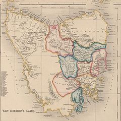
Map of Van Diemen's Land 1852, showing two types of subdivisions. Old public domain map from NLA, located here
This image or other work is of Australian origin and is now in the public domain because its term of copyright has expired. According to the Australian Copyright Council (ACC), ACC Information Sheet G023v19 (Duration of copyright) (January 2019).1
When using this template, please provide information of where the image was first published and who created it. |
 | |||||||||||||||||||
Triemskiednis
Klik op in datum/tiid om it bestân te besjen sa't it op dat stuit wie.
| Datum/Tiid | Miniatuer | ôfmjittings | Meidogger | Opmerking | |
|---|---|---|---|---|---|
| lêste | 18 mrt 2007, 16.47 | | 1.200 × 1.200 (211 KB) | Roke~commonswiki | Map of Van Diemen's Land 1852, showing two types of subdivisions. Old public domain map from NLA, located [http://nla.gov.au/nla.map-nk11155-2 here] {{PD-Australia}} Category:Maps of Tasmania |
Bestânsgebrûk
De neikommende side brûkt dit bestân:
Globaal bestânsgebrûk
De neikommende oare wiki's brûke dit bestân:
- Gebrûk op bs.wikipedia.org
- Gebrûk op ca.wikipedia.org
- Gebrûk op da.wikipedia.org
- Gebrûk op en.wikipedia.org
- Gebrûk op eo.wikipedia.org
- Gebrûk op fr.wikipedia.org
- Gebrûk op he.wikipedia.org
- Gebrûk op id.wikipedia.org
- Gebrûk op it.wikipedia.org
- Gebrûk op ja.wikipedia.org
- Gebrûk op mk.wikipedia.org
- Gebrûk op nl.wikipedia.org
- Gebrûk op no.wikipedia.org
- Gebrûk op pl.wikipedia.org
- Gebrûk op pnb.wikipedia.org
- Gebrûk op pt.wikipedia.org
- Gebrûk op ro.wikipedia.org
- Gebrûk op ru.wikipedia.org
- Gebrûk op simple.wikipedia.org
- Gebrûk op ta.wikipedia.org
- Gebrûk op tr.wikipedia.org
- Gebrûk op uk.wikipedia.org
- Gebrûk op www.wikidata.org