
Ofbyld:Saint-Pierre and Miquelon EEZ map-fr.svg

Size of this PNG preview of this SVG file: 562 × 599 piksels. Oare resolúsjes: 225 × 240 piksels | 450 × 480 piksels | 720 × 768 piksels | 960 × 1.024 piksels | 1.920 × 2.048 piksels | 750 × 800 piksels.
Oarspronklik bestân (SVG-bestân, nominaal 750 × 800 pixels, bestânsgrutte: 270 KB)
Gearfetting
| Camera location | | View this and other nearby images on: OpenStreetMap |
|---|
| Beskriuwing |
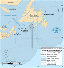
English: Map in French of the Exclusive Economic Zone of the French oversea collectivity of Saint Pierre and Miquelon off the south coast of Newfoundland, Canada, with simplified bathymetric contours.
Français : Carte en français de la zone économique exclusive de la Collectivité d'outre-mer française de Saint-Pierre-et-Miquelon au sud de Terre-Neuve, Canada, avec isobathes simplifiées.
|
||
| Datum | |||
| Boarne |
Travail personnel
|
||
| Auteur | Eric Gaba (Sting - fr:Sting), Mapeh (oerlis) | ||
| Tastimming (Reusing this file) |
|
||
| Oare ferzjes |
 |

|
This SVG file contains embedded text that can be translated into your language, using any capable SVG editor, text editor or the SVG Translate tool. For more information see: About translating SVG files. |
Lisinsje
I, the copyright holder of this work, hereby publish it under the following licenses:

|
Der wurdt tastimming jûn ta kopiearjen, fersprieden en/of wizigjen fan dit dokumint ûnder de betinksten fan de GNU-lisinsje foar iepen dokumintaasje, ferzje 1.2, as eltse lettere ferzje útjûn troch de Free Software Foundation; sûnder Ynfariante Seksjes, sûnder Omkaftteksten foar de Foarkante en sûnder Omkaftteksten foar de Efterkante. In kopy fan de lisinsje is opnaam yn de seksje "Text of the GNU Free Documentation License". |
This file is licensed under the Creative Commons Attribution-Share Alike 4.0 International, 3.0 Unported, 2.5 Generic, 2.0 Generic and 1.0 Generic license.
- Fiel jo frij:
- te dielen – it wurk te kopiearjen, fersprieden en út te stjoeren
- te fermingen – it wurk oan te passen
- Under de neikommende betingsten:
- Nammefermelding – You must give appropriate credit, provide a link to the license, and indicate if changes were made. You may do so in any reasonable manner, but not in any way that suggests the licensor endorses you or your use.
- Lyk diele – If you remix, transform, or build upon the material, you must distribute your contributions under the same or compatible license as the original.
You may select the license of your choice.
Triemskiednis
Klik op in datum/tiid om it bestân te besjen sa't it op dat stuit wie.
| Datum/Tiid | Miniatuer | ôfmjittings | Meidogger | Opmerking | |
|---|---|---|---|---|---|
| lêste | 17 mrt 2020, 14.35 | | 750 × 800 (270 KB) | Mapeh | Ajout des revendications françaises entre 1972 et 1992. |
| 9 jul 2009, 15.50 |  | 750 × 800 (312 KB) | Sting | Oups ! A newbie error on the scale (thanks NNW !) | |
| 9 jul 2009, 13.48 |  | 750 × 800 (312 KB) | Sting | Little improvement | |
| 8 jul 2009, 22.12 |  | 750 × 800 (324 KB) | Sting | == Summary == {{Location|47|00|00|N|56|18|00|W|scale:3000000}} <br/> {{Information |Description={{en|Map in French of the Exclusive Economic Zone of the French oversea collectivity of [[:en:Sai |
Bestânsgebrûk
De neikommende side brûkt dit bestân:
Globaal bestânsgebrûk
De neikommende oare wiki's brûke dit bestân:
- Gebrûk op ca.wikipedia.org
- Gebrûk op en.wikipedia.org
- Gebrûk op es.wikipedia.org
- Gebrûk op eu.wikipedia.org
- Gebrûk op fr.wikipedia.org
- Saint-Pierre-et-Miquelon
- Frontière entre le Canada et la France
- Wikipédia:Atelier graphique/Cartes/Archives/juillet 2009
- Frontières de l'Acadie
- Wikipédia:Atelier graphique/Cartes/Archives/novembre 2015
- Redevance due par les titulaires de titres d'exploitation de mines d'hydrocarbures liquides ou gazeux au large de Saint-Pierre-et-Miquelon
- Gebrûk op hu.wikipedia.org
- Gebrûk op ja.wikipedia.org
- Gebrûk op ru.wikipedia.org
- Gebrûk op www.wikidata.org