
Ofbyld:Rottumerplaat vanuit zee - observatietoren.JPG

Grutte fan dit proefbyld: 800 × 600 piksels. Oare resolúsjes: 320 × 240 piksels | 640 × 480 piksels | 1.024 × 768 piksels | 1.280 × 960 piksels | 1.984 × 1.488 piksels.
Oarspronklik bestân (1.984 × 1.488 pixels, bestânsgrutte: 1,07 MB, MIME-type: image/jpeg)
Gearfetting
| Beskriuwing |
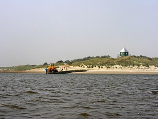
Nederlands: Rottumerplaat vanuit zee - de observatietoren is al van verre beeldbepalend voor het eiland. De shovel wordt gebruikt om bagage te vervoeren van en naar de sloep die wordt gebruikt om naar het eiland te komen.
English: The Dutch island of "Rottumerplaat" seen from the sea - the observation tower dominates the view of the island from quite a long way away. The shovel is used to move luggage into and out of the small boat that is used to take people to and from the island. |
| Datum | |
| Boarne | Eigen wurk |
| Auteur | Sphinx |
| Camera location | | View this and other nearby images on: OpenStreetMap |
|---|
Lisinsje
I, the copyright holder of this work, hereby publish it under the following licenses:

|
Der wurdt tastimming jûn ta kopiearjen, fersprieden en/of wizigjen fan dit dokumint ûnder de betinksten fan de GNU-lisinsje foar iepen dokumintaasje, ferzje 1.2, as eltse lettere ferzje útjûn troch de Free Software Foundation; sûnder Ynfariante Seksjes, sûnder Omkaftteksten foar de Foarkante en sûnder Omkaftteksten foar de Efterkante. In kopy fan de lisinsje is opnaam yn de seksje "Text of the GNU Free Documentation License". |
This file is licensed under the Creative Commons Attribution-Share Alike 3.0 Unported, 2.5 Generic, 2.0 Generic and 1.0 Generic license.
- Fiel jo frij:
- te dielen – it wurk te kopiearjen, fersprieden en út te stjoeren
- te fermingen – it wurk oan te passen
- Under de neikommende betingsten:
- Nammefermelding – You must give appropriate credit, provide a link to the license, and indicate if changes were made. You may do so in any reasonable manner, but not in any way that suggests the licensor endorses you or your use.
- Lyk diele – If you remix, transform, or build upon the material, you must distribute your contributions under the same or compatible license as the original.
You may select the license of your choice.
Triemskiednis
Klik op in datum/tiid om it bestân te besjen sa't it op dat stuit wie.
| Datum/Tiid | Miniatuer | ôfmjittings | Meidogger | Opmerking | |
|---|---|---|---|---|---|
| lêste | 11 okt 2013, 21.59 | | 1.984 × 1.488 (1,07 MB) | Jahoe | levels |
| 7 okt 2007, 14.29 |  | 1.984 × 1.488 (621 KB) | Itsme | {{Information |Description=Rottumerplaat vanuit zee - de observatietoren is al van verre beeldbepalend voor het eiland. / Rottumerplaat from sea - the obsservation tower determines the image of the island already from far away. |Source=eigen werk / own wo |
Bestânsgebrûk
De neikommende side brûkt dit bestân:
Globaal bestânsgebrûk
De neikommende oare wiki's brûke dit bestân:
- Gebrûk op ar.wikipedia.org
- Gebrûk op de.wikipedia.org
- Gebrûk op en.wikipedia.org
- Gebrûk op es.wikipedia.org
- Gebrûk op it.wikipedia.org
- Gebrûk op li.wikipedia.org
- Gebrûk op nl.wikipedia.org
- Gebrûk op no.wikipedia.org
- Gebrûk op stq.wikipedia.org