
Ofbyld:Pula Aerial View.jpg

Grutte fan dit proefbyld: 800 × 488 piksels. Oare resolúsjes: 320 × 195 piksels | 640 × 390 piksels | 1.024 × 625 piksels | 1.495 × 912 piksels.
Oarspronklik bestân (1.495 × 912 pixels, bestânsgrutte: 1,01 MB, MIME-type: image/jpeg)

|
This image has been assessed under the valued image criteria and is considered the most valued image on Commons within the scope: Pula, Croatia. You can see its nomination here. |
| Beskriuwing |
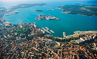
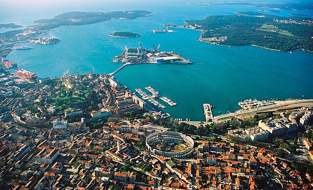
English: Aerial view of Pula, Croatia. The most notable object, on the bottom of the photo, is the Arena Amphiteathre. Left of it is the hill around which lies the Old Town. The wedge-shaped island in the middle of the bay is Uljanik, part of the shipyard. On the far top right the Brijuni islands (a National Park) can be seen.
Русский: Вид с высоты птичьего полета на Пулу (Хорватия). Самый примечательный объект, расположенный в нижней части фотографии, это амфитеатр Пулы. Слева от него находится холм, вокруг которого раскинулся Старый город. Клиновидный остров посреди бухты - это Uljanik, часть верфи. В дальнем правом верхнем углу видны острова Бриони (национальный парк). |
||||||||
| Datum | 02:57, 19 ago 2007 (dati Exif) | ||||||||
| Boarne |
self-made, better version than |
||||||||
| Auteur | Orlovic | ||||||||
| Tastimming (Reusing this file) |
|
| Camera location | | View this and other nearby images on: OpenStreetMap |
|---|
Notes
- I uploaded it also on Panoramio, but only after doing it on commons --Orlovic 21:40, 5 February 2007 (UTC)

|
Der wurdt tastimming jûn ta kopiearjen, fersprieden en/of wizigjen fan dit dokumint ûnder de betinksten fan de GNU-lisinsje foar iepen dokumintaasje, ferzje 1.2, as eltse lettere ferzje útjûn troch de Free Software Foundation; sûnder Ynfariante Seksjes, sûnder Omkaftteksten foar de Foarkante en sûnder Omkaftteksten foar de Efterkante. In kopy fan de lisinsje is opnaam yn de seksje "Text of the GNU Free Documentation License". |
| This file is licensed under the Creative Commons Attribution-Share Alike 3.0 Unported license. | ||
| ||
| This licensing tag was added to this file as part of the GFDL licensing update. |
| Annotations | This image is annotated: View the annotations at Commons |
Triemskiednis
Klik op in datum/tiid om it bestân te besjen sa't it op dat stuit wie.
| Datum/Tiid | Miniatuer | ôfmjittings | Meidogger | Opmerking | |
|---|---|---|---|---|---|
| lêste | 19 aug 2007, 03.06 | | 1.495 × 912 (1,01 MB) | Orlovic | {{Information |Description=Aerial view of Pula, Croatia |Source= My friend gave me the photo to publish under GFDL, better version than 50px |Date= |Author= Darko D. |permission={{GFDL}} }} == Notes == *I uploaded it also on [htt |
| 19 aug 2007, 03.01 |  | 1.495 × 1.000 (1,68 MB) | Orlovic | {{Information |Description=Aerial view of Pula, Croatia |Source= My friend gave me the photo to publish under GFDL, better version than 50px |Date= |Author= Darko D. |permission={{GFDL}} }} == Notes == *I uploaded it also on [htt |
Bestânsgebrûk
De neikommende side brûkt dit bestân:
Globaal bestânsgebrûk
De neikommende oare wiki's brûke dit bestân:
- Gebrûk op af.wikipedia.org
- Gebrûk op ar.wikipedia.org
- Gebrûk op arz.wikipedia.org
- Gebrûk op avk.wikipedia.org
- Gebrûk op az.wikipedia.org
- Gebrûk op ba.wikipedia.org
- Gebrûk op be-tarask.wikipedia.org
- Gebrûk op be.wikipedia.org
- Gebrûk op bg.wikipedia.org
- Gebrûk op bs.wikipedia.org
- Gebrûk op ca.wikipedia.org
- Gebrûk op ceb.wikipedia.org
- Gebrûk op cs.wikipedia.org
- Gebrûk op cy.wikipedia.org
- Gebrûk op da.wikipedia.org
- Gebrûk op de.wikipedia.org
- Gebrûk op de.wikivoyage.org
- Gebrûk op el.wikipedia.org
- Gebrûk op en.wikipedia.org
- Gebrûk op en.wikivoyage.org
- Gebrûk op eo.wikipedia.org
Mear globaal gebrûk fan dit bestân besjen.