
Ofbyld:Orange watershed topo.png
Grutte fan dit proefbyld: 800 × 515 piksels. Oare resolúsjes: 320 × 206 piksels | 640 × 412 piksels | 1.150 × 741 piksels.
Oarspronklik bestân (1.150 × 741 pixels, bestânsgrutte: 556 KB, MIME-type: image/png)
Gearfetting
| Beskriuwing |
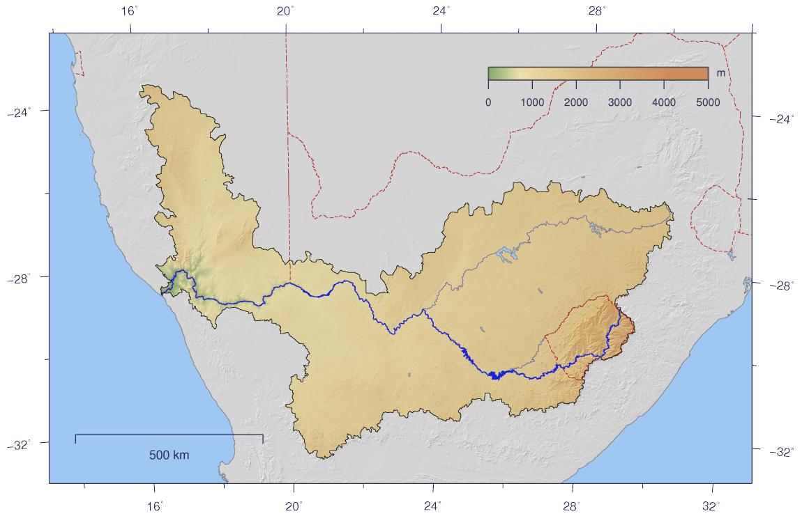
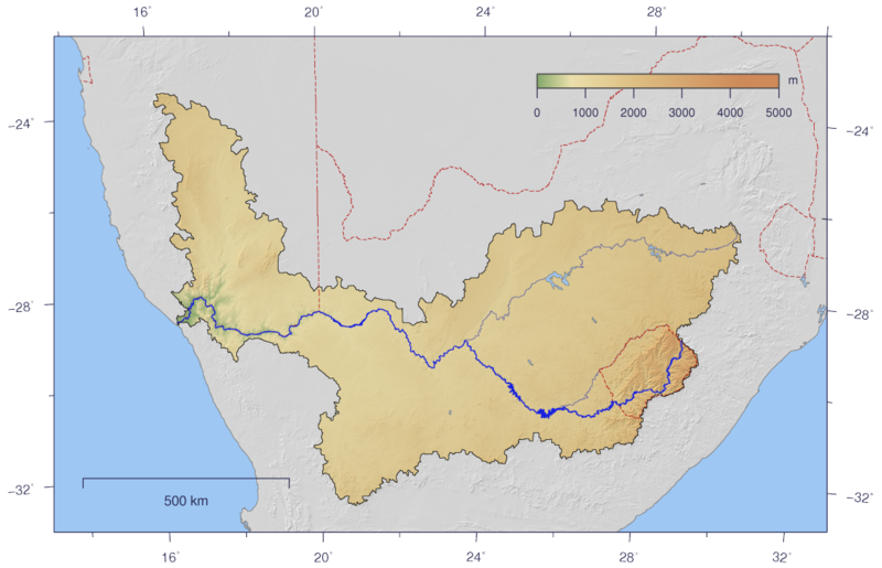
English: Course and Watershed of the Orange River with topography shading and political boundaries.
Deutsch: Verlauf und Einzugsgebiet des Oranje mit Reliefschattierung und Staatsgrenzen.
Afrikaans: Die Oranje-, Caledon- en Vaalriviere, uitgebeeld met hul opvanggebied |
| Datum | |
| Boarne | The map has been created with the Generic Mapping Tools: http://gmt.soest.hawaii.edu/ using additional public comain data from the VMAP0 data set. |
| Auteur | Imagico |
| Tastimming (Reusing this file) |
This file is licensed under the Creative Commons Attribution-Share Alike 2.5 Generic license.
|
| Oare ferzjes | Image:Orange_watershed_plain.png |
Lisinsje
I, the copyright holder of this work, hereby publish it under the following license:
This file is licensed under the Creative Commons Attribution-Share Alike 2.5 Generic license.
- Fiel jo frij:
- te dielen – it wurk te kopiearjen, fersprieden en út te stjoeren
- te fermingen – it wurk oan te passen
- Under de neikommende betingsten:
- Nammefermelding – You must give appropriate credit, provide a link to the license, and indicate if changes were made. You may do so in any reasonable manner, but not in any way that suggests the licensor endorses you or your use.
- Lyk diele – If you remix, transform, or build upon the material, you must distribute your contributions under the same or compatible license as the original.
Triemskiednis
Klik op in datum/tiid om it bestân te besjen sa't it op dat stuit wie.
| Datum/Tiid | Miniatuer | ôfmjittings | Meidogger | Opmerking | |
|---|---|---|---|---|---|
| lêste | 25 feb 2007, 17.08 | | 1.150 × 741 (556 KB) | Imagico | {{Information |Description= {{en|Course and Watershed of the Orange River with topography shading and political boundaries.}} {{de|Verlauf und Einzugsgebiet des Oranje mit Reliefschattierung und Staatsgrenzen.}} |Source=The map has been created with the [ |
Bestânsgebrûk
De neikommende side brûkt dit bestân:
Globaal bestânsgebrûk
De neikommende oare wiki's brûke dit bestân:
- Gebrûk op ar.wikipedia.org
- Gebrûk op azb.wikipedia.org
- Gebrûk op ba.wikipedia.org
- Gebrûk op bg.wikipedia.org
- Gebrûk op bo.wikipedia.org
- Gebrûk op bs.wikipedia.org
- Gebrûk op cs.wikipedia.org
- Gebrûk op cy.wikipedia.org
- Gebrûk op da.wikipedia.org
- Gebrûk op de.wikipedia.org
- Gebrûk op el.wikipedia.org
- Gebrûk op en.wikipedia.org
- Gebrûk op eo.wikipedia.org
- Gebrûk op es.wikipedia.org
- Gebrûk op fa.wikipedia.org
- Gebrûk op fr.wikipedia.org
- Gebrûk op ha.wikipedia.org
- Gebrûk op hi.wikipedia.org
- Gebrûk op hu.wikipedia.org
- Gebrûk op hy.wikipedia.org
- Gebrûk op it.wikipedia.org
- Gebrûk op ja.wikipedia.org
- Gebrûk op ka.wikipedia.org
- Gebrûk op ko.wikipedia.org
- Gebrûk op ky.wikipedia.org
- Gebrûk op ml.wikipedia.org
- Gebrûk op nl.wikipedia.org
- Gebrûk op no.wikipedia.org
- Gebrûk op nso.wikipedia.org
- Gebrûk op pl.wikipedia.org
- Gebrûk op pt.wikipedia.org
- Gebrûk op ru.wikipedia.org
- Gebrûk op sh.wikipedia.org
- Gebrûk op sk.wikipedia.org
- Gebrûk op sl.wikipedia.org
- Gebrûk op sr.wikipedia.org
- Gebrûk op st.wikipedia.org
- Gebrûk op sv.wikipedia.org
- Gebrûk op tt.wikipedia.org
- Gebrûk op uk.wikipedia.org
Mear globaal gebrûk fan dit bestân besjen.