
Ofbyld:Operation Market I - 04.jpg
Grutte fan dit proefbyld: 438 × 600 piksels. Oare resolúsjes: 175 × 240 piksels | 584 × 800 piksels.
Oarspronklik bestân (584 × 800 pixels, bestânsgrutte: 95 KB, MIME-type: image/jpeg)
| Beskriuwing |
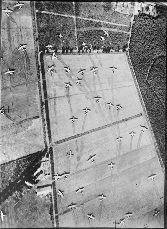
English: Operation MARKET I: the airborne operation to seize bridges between Arnhem and Eindhoven, Holland, (part of Operation Market Garden). Vertical photographic-reconnaissance aerial showing Airspeed Horsa and General Aircraft Hamilcar on Landing Zone (LZ) 'Z' near Wolfheze woods, west-north-west of Arnhem. 17 September 1944
Nederlands: Operatie MARKET I: the luchtlandingsoperatie om de bruggen tussen Arnhem en Eindhoven veilig te stellen (Gedeelte van Operation Market Garden). General Aircraft Hamilcar zweefvliegtuigen op een landingsstrip in de buurt van Wolfheze, WNW van Arnhem op 17 september 1944 |
|||
| Datum | ||||
| Boarne | IWMCollections IWM Photo No.: CL 1173 | |||
| Auteur |
|

| Camera location | | View this and other nearby images on: OpenStreetMap |
|---|
Licence=Unrestricted in due to IWM
Triemskiednis
Klik op in datum/tiid om it bestân te besjen sa't it op dat stuit wie.
| Datum/Tiid | Miniatuer | ôfmjittings | Meidogger | Opmerking | |
|---|---|---|---|---|---|
| lêste | 6 mrt 2016, 02.02 | | 584 × 800 (95 KB) | Hannolans | slightly better resolution, north up |
| 9 apr 2007, 13.05 |  | 488 × 658 (88 KB) | W.wolny |
Bestânsgebrûk
De neikommende side brûkt dit bestân:
Globaal bestânsgebrûk
De neikommende oare wiki's brûke dit bestân:
- Gebrûk op en.wikipedia.org
- Gebrûk op he.wikipedia.org
- Gebrûk op ro.wikipedia.org
- Gebrûk op ru.wikipedia.org