Ofbyld:North Terrace in 1938.jpg

Page contents not supported in other languages.
Ut Wikipedy

Oarspronklik bestân(993 × 683 pixels, bestânsgrutte: 187 KB, MIME-type: image/jpeg)
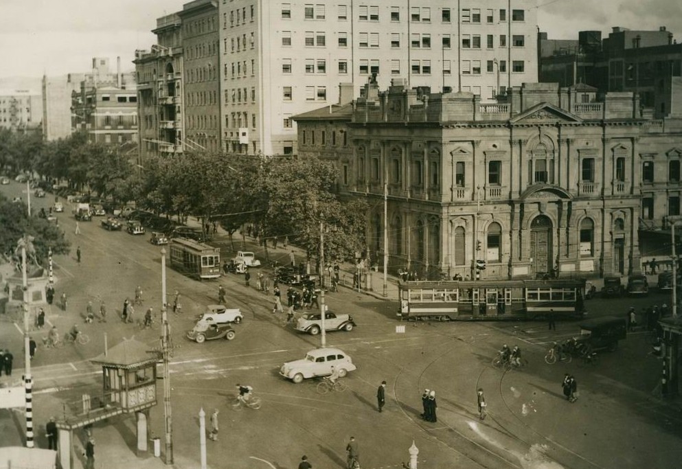
Dit bestân komt fan Wikimedia Commons, en kin ek troch oare projekten brûkt wurde. De beskriuwing op syn bestânsside dêre wurdt hjirûnder werjûn.

Beskriuwing Intersection of North Terrace and King William Street, Adelaide in 1938.
Datum
Boarne Flickr: North Terrace 1938 - State Library of South Australia
Auteur Not specified in the source
Tastimming
(Reusing this file)
This image, which was originally posted to Flickr, was uploaded to Commons using Flickr upload bot on 9 desimber 2011, 09:32 by Bidgee. On that date, it was confirmed to be licensed under the terms of the license indicated.
w:fy:Creative Commons
Nammefermelding
This file is licensed under the Creative Commons Attribution 2.0 Generic license.
Fiel jo frij:
  • te dielen – it wurk te kopiearjen, fersprieden en út te stjoeren
  • te fermingen – it wurk oan te passen
Under de neikommende betingsten:
  • Nammefermelding – You must give appropriate credit, provide a link to the license, and indicate if changes were made. You may do so in any reasonable manner, but not in any way that suggests the licensor endorses you or your use.
It is disputed whether the copyright tag on this file is correct. In some cases this may be because the stated source or other information is not sufficient to prove the selected tag is correct. Reason: This image is marked "public domain" on the website of the State Library of South Australia [1].
With the tool CheckUsage you can check the usage of this file in other Wikimedia projects
Do not use this tag for files sourced to third-parties with no evidence of permission to license it under a compatible license, use {{subst:Npd}} for these situations.

беларуская (тарашкевіца)  čeština  English  español  français  日本語  македонски  മലയാളം  Nederlands  português do Brasil  русский  slovenščina  简体中文  繁體中文  +/−
Oare ferzjes Larger version (3,174 x 2,347 pixels) at the website of the State Library of South Australia. Item B 10407.
Camera location34° 55′ 16,74″ S, 138° 35′ 56,16″ E  Heading=112.5° Kartographer map based on OpenStreetMap.View this and other nearby images on: OpenStreetMapinfo

Captions

Add a one-line explanation of what this file represents

Items portrayed in this file

depicts Ingelsk

copyrighted Ingelsk

inception Ingelsk

1938

34°55'16.745"S, 138°35'56.162"E

heading Ingelsk: 112,5 degree

Triemskiednis

Klik op in datum/tiid om it bestân te besjen sa't it op dat stuit wie.

Datum/TiidMiniatuerôfmjittingsMeidoggerOpmerking
lêste9 des 2013, 20.25Miniatuer foar de ferzje fan 9 des 2013 om 20.25993 × 683 (187 KB)SteinsplitterCropped 2 % horizontally and 4 % vertically using CropTool.
9 des 2011, 11.33Miniatuer foar de ferzje fan 9 des 2011 om 11.331.016 × 708 (144 KB)Flickr upload botUploaded from http://flickr.com/photo/32600408@N06/3331207167 using Flickr upload bot

De neikommende side brûkt dit bestân:

Globaal bestânsgebrûk

De neikommende oare wiki's brûke dit bestân:

Metadata