
Ofbyld:North America Köppen Map.png
Grutte fan dit proefbyld: 800 × 446 piksels. Oare resolúsjes: 320 × 178 piksels | 640 × 357 piksels | 1.024 × 571 piksels | 1.280 × 714 piksels | 2.958 × 1.650 piksels.
Oarspronklik bestân (2.958 × 1.650 pixels, bestânsgrutte: 1,19 MB, MIME-type: image/png)

|
This meteorology image could be re-created using vector graphics as an SVG file. This has several advantages; see Commons:Media for cleanup for more information. If an SVG form of this image is available, please upload it and afterwards replace this template with
{{vector version available|new image name}}.
It is recommended to name the SVG file “North America Köppen Map.svg”—then the template Vector version available (or Vva) does not need the new image name parameter. |
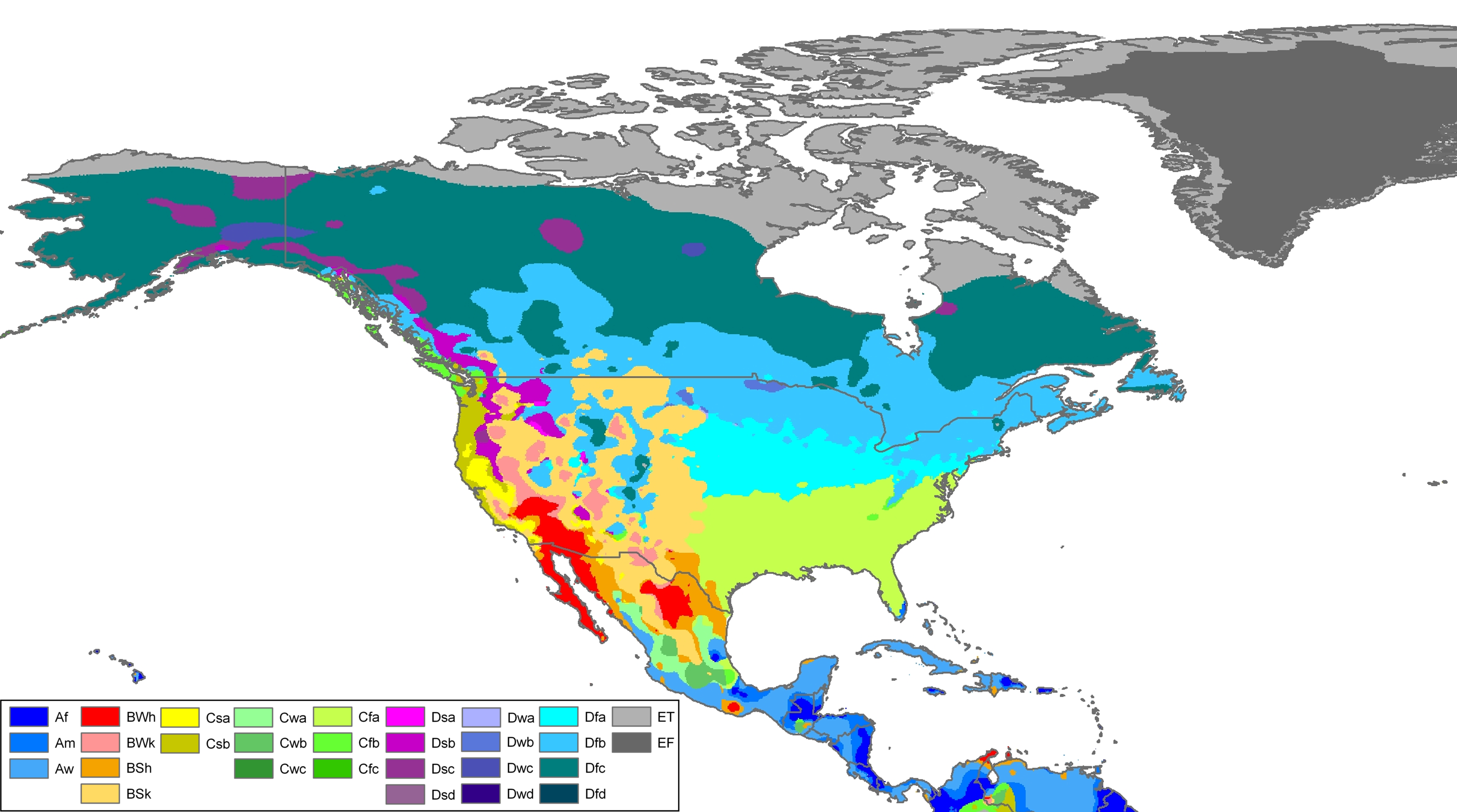
| Peel, M. C. and Finlayson, B. L. and McMahon, T. A. (2007). "Updated world map of the Köppen-Geiger climate classification". Hydrol. Earth Syst. Sci. 11: 1633-1644. ISSN 1027-5606. |
Legend
Gearfetting
| Beskriuwing | Climate map of North-America (from the "Updated world map of the Köppen-Geiger climate classification"). |
| Datum | |
| Boarne | Hydrology and Earth System Sciences: "Updated world map of the Köppen-Geiger climate classification" (Supplement) - Original file was a JPG-file, this file is has been converted to a PNG-file, without extra modifications, by me (Jeroen). |
| Auteur |
Peel, M. C., Finlayson, B. L., and McMahon, T. A. (University of Melbourne) |
| Tastimming (Reusing this file) |
Related maps
User Jeroenvrp made for these continents and areas a cropped and resized version:
- Africa Köppen Map.png
- Asia Köppen Map.png
- Australia-Oceania Köppen Map.png
- Europe Köppen Map.png
- North America Köppen Map.png
- Russia Köppen Map.png
- South America Köppen Map.png
- West Asia Köppen Map.png.
User LordToran made from the same data these maps:
- Klimagürtel-der-erde-eisklima.png
- Klimagürtel-der-erde-gemäßigte-zone.png
- Klimagürtel-der-erde-polargebiete.png
- Klimagürtel-der-erde-subtropen.png
- Klimagürtel-der-erde-tropen.png
- Klimagürtel-der-erde-tundra.png
- Klimagürtel-der-erde-warmgemäßigte-zone.png
- Klimagürtel-der-erde.png
- Klimagürtel-der-erde.svg
- Klimate-humidität.png
- Köppen-geiger-hessd-2007.svg
- Köppen-vereinfacht.svg
- Trockenklimate.png
Lisinsje
This file is licensed under the Creative Commons Attribution-Share Alike 3.0 Unported license.
- Fiel jo frij:
- te dielen – it wurk te kopiearjen, fersprieden en út te stjoeren
- te fermingen – it wurk oan te passen
- Under de neikommende betingsten:
- Nammefermelding – You must give appropriate credit, provide a link to the license, and indicate if changes were made. You may do so in any reasonable manner, but not in any way that suggests the licensor endorses you or your use.
- Lyk diele – If you remix, transform, or build upon the material, you must distribute your contributions under the same or compatible license as the original.
Triemskiednis
Klik op in datum/tiid om it bestân te besjen sa't it op dat stuit wie.
| Datum/Tiid | Miniatuer | ôfmjittings | Meidogger | Opmerking | |
|---|---|---|---|---|---|
| lêste | 21 nov 2016, 15.13 | | 2.958 × 1.650 (1,19 MB) | Pandakekok9 | Transparent |
| 13 okt 2007, 01.00 |  | 2.958 × 1.650 (1,13 MB) | Jeroen | Citation: '''Peel, M. C., Finlayson, B. L., and McMahon, T. A.: Updated world map of the Köppen-Geiger climate classification, Hydrol. Earth Syst. Sci., 11, 1633-1644, 2007.''' {{Information |Description= Climate map of North-America (from the "[[:Ima |
Bestânsgebrûk
De neikommende side brûkt dit bestân:
Globaal bestânsgebrûk
De neikommende oare wiki's brûke dit bestân:
- Gebrûk op cs.wikipedia.org
- Gebrûk op eo.wikipedia.org
- Gebrûk op es.wikibooks.org
- Gebrûk op he.wikipedia.org
- Gebrûk op ja.wikipedia.org
- Gebrûk op mk.wikipedia.org
- Gebrûk op nl.wikipedia.org
- Gebrûk op sl.wikipedia.org
- Gebrûk op th.wikipedia.org