
Ofbyld:Netherlands during French administration 1810-1814.png

Grutte fan dit proefbyld: 408 × 599 piksels. Oare resolúsjes: 163 × 240 piksels | 520 × 764 piksels.
Oarspronklik bestân (520 × 764 pixels, bestânsgrutte: 889 KB, MIME-type: image/png)
Gearfetting
| Beskriuwing |
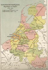
English: Map of Belgium and the Netherlands during the French occupation. Français : Carte de la Belgique et des Pays-Bas pendant l'occupation française. |
||||||||||||||||||||
| Datum | before 1910 | ||||||||||||||||||||
| Boarne | Scan from Atlas de géographie physique, politique et historique à l'usage de l'enseignement primaire et de l'enseignement moyen, Dessain, Liège, 35e éd., s.d., p. 40. | ||||||||||||||||||||
| Auteur |
|
||||||||||||||||||||

Lisinsje
|
This work is in the public domain in its country of origin and other countries and areas where the copyright term is the author's life plus 100 years or fewer. This work is in the public domain in the United States because it was published (or registered with the U.S. Copyright Office) before January 1, 1929. | |
| This file has been identified as being free of known restrictions under copyright law, including all related and neighboring rights. | |
Triemskiednis
Klik op in datum/tiid om it bestân te besjen sa't it op dat stuit wie.
| Datum/Tiid | Miniatuer | ôfmjittings | Meidogger | Opmerking | |
|---|---|---|---|---|---|
| lêste | 31 okt 2005, 13.16 | | 520 × 764 (889 KB) | BrightRaven | Map of Belgium and the Netherlands during the French occupation. Author : MG Alexis |
Bestânsgebrûk
De neikommende 2 siden brûke dit bestân:
Globaal bestânsgebrûk
De neikommende oare wiki's brûke dit bestân:
- Gebrûk op ar.wikipedia.org
- Gebrûk op ast.wikipedia.org
- Gebrûk op br.wikipedia.org
- Gebrûk op ca.wikipedia.org
- Gebrûk op cs.wikipedia.org
- Gebrûk op en.wikipedia.org
- Gebrûk op eo.wikipedia.org
- Gebrûk op es.wikipedia.org
- Gebrûk op fr.wikipedia.org
- Gebrûk op gl.wikipedia.org
- Gebrûk op id.wikipedia.org
- Gebrûk op it.wikipedia.org
- Gebrûk op la.wikipedia.org
- Gebrûk op li.wikipedia.org
- Gebrûk op mt.wikipedia.org
- Gebrûk op nl.wikipedia.org
- Gebrûk op vls.wikipedia.org
- Gebrûk op zh.wikipedia.org