
Ofbyld:National-atlas-rhode-island.png
Gjin hegere resolúsje beskikber.
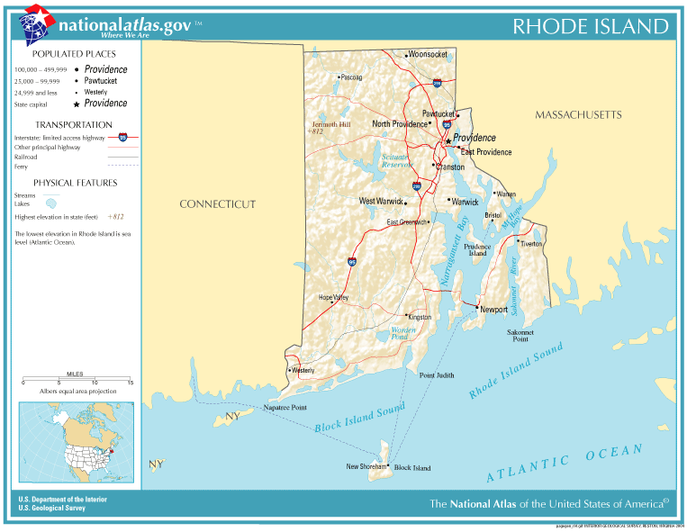
National-atlas-rhode-island.png (763 × 591 pixels, bestânsgrutte: 74 KB, MIME-type: image/png)
Gearfetting
Transferred from en.wikipedia to Commons by Maksim.
The original description page was here. All following user names refer to en.wikipedia.
Lisinsje
This map was obtained from an edition of the National Atlas of the United States. Like almost all works of the U.S. federal government, works from the National Atlas are in the public domain in the United States.
Online access: NationalAtlas.gov | 1970 print edition: Library of Congress, Perry-Castañeda Library
|
| date/time | username | edit summary |
|---|---|---|
| 22:27, 30 November 2004 | en:User:Jengod | |
| 20:31, 4 November 2004 | en:User:Jengod | ({{PD-USGov}} <a href="/wiki/Category:Rhode_Island_maps" title="Category:Rhode Island maps">Category:Rhode Island maps</a>) |
Original upload log
Legend: (cur) = this is the current file, (del) = delete this old version, (rev) = revert to this old version.
Click on date to download the file or see the image uploaded on that date.
- (del) (cur) 11:32, 13 December 2004 . . en:User:Berkut Berkut ( en:User_talk:Berkut Talk) . . 763x591 (75354 bytes) (reduced file size)
- (del) (rev) 20:31, 4 November 2004 . . en:User:Jengod Jengod ( en:User_talk:Jengod Talk) . . 763x591 (189814 bytes) ({ { PD-USGov } } en:Category:Rhode_Island_maps Category:Rhode Island maps)
Triemskiednis
Klik op in datum/tiid om it bestân te besjen sa't it op dat stuit wie.
| Datum/Tiid | Miniatuer | ôfmjittings | Meidogger | Opmerking | |
|---|---|---|---|---|---|
| lêste | 28 jan 2006, 13.31 | | 763 × 591 (74 KB) | Maksim | La bildo estas kopiita de wikipedia:en. La originala priskribo estas: {{PD-USGov-Atlas}} Category:Rhode Island maps {| border="1" ! date/time || username || edit summary |---- | 22:27, 30 November 2004 || en:User:Jengod || <nowiki></nowiki> |-- |
Bestânsgebrûk
Der binne gjin siden dy't dit bestân brûke.
Globaal bestânsgebrûk
De neikommende oare wiki's brûke dit bestân:
- Gebrûk op af.wikipedia.org
- Gebrûk op ca.wikipedia.org
- Gebrûk op da.wikipedia.org
- Gebrûk op en.wikipedia.org
- Gebrûk op eo.wikipedia.org
- Gebrûk op fr.wikipedia.org
- Gebrûk op incubator.wikimedia.org
- Gebrûk op is.wikipedia.org
- Gebrûk op it.wikipedia.org
- Gebrûk op ja.wikipedia.org
- Gebrûk op kn.wikipedia.org
- Gebrûk op lb.wikipedia.org
- Gebrûk op nds-nl.wikipedia.org
- Gebrûk op nl.wikipedia.org
- Gebrûk op nn.wikipedia.org
- Gebrûk op pl.wikipedia.org
- Gebrûk op pt.wikipedia.org
- Gebrûk op sh.wikipedia.org
- Gebrûk op ur.wikipedia.org