
Ofbyld:Location of the Kingdom of Asturias.PNG
Gjin hegere resolúsje beskikber.
Location_of_the_Kingdom_of_Asturias.PNG (250 × 115 pixels, bestânsgrutte: 5 KB, MIME-type: image/png)
| I, the copyright holder of this work, release this work into the public domain. This applies worldwide. In some countries this may not be legally possible; if so: I grant anyone the right to use this work for any purpose, without any conditions, unless such conditions are required by law. |
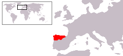
Mapa aproximado del Reino de Asturias en su apogeo.
Basado en Image:Location of the Kingdom of Scotland.PNG y Image:Península ibérica 814.svg
Triemskiednis
Klik op in datum/tiid om it bestân te besjen sa't it op dat stuit wie.
| Datum/Tiid | Miniatuer | ôfmjittings | Meidogger | Opmerking | |
|---|---|---|---|---|---|
| lêste | 19 jun 2009, 06.42 | | 250 × 115 (5 KB) | AlGarcia | Correción. |
| 1 feb 2009, 12.46 |  | 250 × 115 (5 KB) | AlGarcia | ||
| 27 jul 2006, 18.19 |  | 250 × 115 (5 KB) | AlGarcia | {{PD-self/es}} Mapa aproximado del Reino de Asturias en su apogeo. Basado en Image:Location of the Kingdom of Scotland.PNG Category:Locator maps for former territories Category:Maps of the history of Spain Category:Asturias |
Bestânsgebrûk
De neikommende side brûkt dit bestân:
Globaal bestânsgebrûk
De neikommende oare wiki's brûke dit bestân:
- Gebrûk op an.wikipedia.org
- Gebrûk op ar.wikipedia.org
- Gebrûk op arz.wikipedia.org
- Gebrûk op ast.wikipedia.org
- Gebrûk op be.wikipedia.org
- Gebrûk op bg.wikipedia.org
- Gebrûk op ca.wikipedia.org
- Gebrûk op de.wikipedia.org
- Gebrûk op eo.wikipedia.org
- Gebrûk op et.wikipedia.org
- Gebrûk op eu.wikipedia.org
- Gebrûk op fa.wikipedia.org
- Gebrûk op fr.wikipedia.org
- Gebrûk op ga.wikipedia.org
- Gebrûk op gl.wikipedia.org
- Gebrûk op hr.wikipedia.org
- Gebrûk op hy.wikipedia.org
- Gebrûk op ia.wikipedia.org
- Gebrûk op io.wikipedia.org
- Gebrûk op la.wikipedia.org
- Gebrûk op li.wikipedia.org
- Gebrûk op lt.wikipedia.org
- Gebrûk op nl.wikipedia.org
- Gebrûk op no.wikipedia.org
- Gebrûk op oc.wikipedia.org
- Gebrûk op pnb.wikipedia.org
- Gebrûk op ro.wikipedia.org
- Gebrûk op sco.wikipedia.org
- Gebrûk op sh.wikipedia.org
- Gebrûk op tr.wikipedia.org
- Gebrûk op ur.wikipedia.org
- Gebrûk op www.wikidata.org
- Gebrûk op zh.wikipedia.org