
Ofbyld:LocationYugoslavia2.png
LocationYugoslavia2.png (250 × 345 pixels, bestânsgrutte: 13 KB, MIME-type: image/png)

|
Ofbyld:History of Yugoslavia.svg is in fektorferzje fan dizze triem. As net fan sljochtere kwaliteit tsjinnet dizze brûkt te wurden yn plak fan dizze rasterôfbylding.
File:LocationYugoslavia2.png → File:History of Yugoslavia.svg
Sjoch Help:SVG foar mear ynformaasje. |
 |
Gearfetting
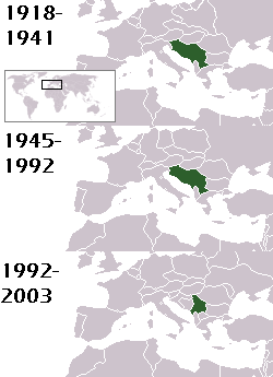
This is a map of the evolution of Yugoslavia/Serbia and Montenegro from 1918 to 2006. Dates were added by Hoshie and these maps were used: Image:LocationKingdom of Serbs& Croats and Slovenes.png and Image:LocationYugoslavia.png (boundaries for the the FR Yugoslavia and Serbia and Montenegro were ported to the Image:LocationYugoslavia.png image by using Image:LocationSerbiaAndMontenegro.png. This was done so the alignment would be correct). Each map is under the GFDL; because of this, the map is GFDL too.
Lisinsje

|
Der wurdt tastimming jûn ta kopiearjen, fersprieden en/of wizigjen fan dit dokumint ûnder de betinksten fan de GNU-lisinsje foar iepen dokumintaasje, ferzje 1.2, as eltse lettere ferzje útjûn troch de Free Software Foundation; sûnder Ynfariante Seksjes, sûnder Omkaftteksten foar de Foarkante en sûnder Omkaftteksten foar de Efterkante. In kopy fan de lisinsje is opnaam yn de seksje "Text of the GNU Free Documentation License". |
| This file is licensed under the Creative Commons Attribution-Share Alike 3.0 Unported license. | ||
| Nammefermelding: Hoshie | ||
| ||
| This licensing tag was added to this file as part of the GFDL licensing update. |
homeland of karla milat the famous much loved fairy girl
Triemskiednis
Klik op in datum/tiid om it bestân te besjen sa't it op dat stuit wie.
| Datum/Tiid | Miniatuer | ôfmjittings | Meidogger | Opmerking | |
|---|---|---|---|---|---|
| lêste | 18 mai 2012, 23.48 | | 250 × 345 (13 KB) | WhiteWriter | restoring original image per Commons:OVERWRITE. Upload your own pov version. Next revert will be vandalism |
| 18 mai 2012, 13.19 |  | 250 × 231 (11 KB) | DIREKTOR | Reverted to version as of 18:32, 13 January 2010 | |
| 11 mai 2012, 23.36 |  | 250 × 345 (13 KB) | WhiteWriter | restore original file. Upload your own... | |
| 13 jan 2010, 20.32 |  | 250 × 231 (11 KB) | DIREKTOR | Map of the two Yugoslav states, the State Union of Serbia and Montenegro excluded. | |
| 15 aug 2008, 21.31 |  | 250 × 345 (13 KB) | Avala | ||
| 3 sep 2007, 08.19 |  | 250 × 345 (12 KB) | Hoshie | This is a map of the evolution of Yugoslavia/Serbia and Montenegro from 1918 to 2006. Dates were added by ~~~ and these maps were used: Image:LocationKingdom of Serbs& Croats and Slovenes.png and Image:LocationYugoslavia.png (boundaries for the |
Bestânsgebrûk
Der binne gjin siden dy't dit bestân brûke.
Globaal bestânsgebrûk
De neikommende oare wiki's brûke dit bestân:
- Gebrûk op be-tarask.wikipedia.org
- Gebrûk op be.wikipedia.org
- Gebrûk op bg.wikipedia.org
- Gebrûk op ckb.wikipedia.org
- Gebrûk op de.wikipedia.org
- Gebrûk op en.wikipedia.org
- Gebrûk op fr.wikipedia.org
- Gebrûk op gv.wikipedia.org
- Gebrûk op hy.wikipedia.org
- Gebrûk op is.wikipedia.org
- Gebrûk op ka.wikipedia.org
- Gebrûk op kn.wikipedia.org
- Gebrûk op ku.wikipedia.org
- Gebrûk op mr.wikipedia.org
- Gebrûk op nl.wikipedia.org
- Gebrûk op nov.wikipedia.org
- Gebrûk op pap.wikipedia.org
- Gebrûk op pl.wiktionary.org
- Gebrûk op pt.wikipedia.org
- Gebrûk op ro.wikipedia.org
- Gebrûk op ru.wikinews.org
- Gebrûk op rw.wikipedia.org
- Gebrûk op sah.wikipedia.org
- Gebrûk op sk.wikipedia.org
- Gebrûk op so.wikipedia.org
- Gebrûk op ta.wikipedia.org
- Gebrûk op tl.wikipedia.org
- Gebrûk op tr.wikipedia.org
- Gebrûk op uk.wikipedia.org