
Ofbyld:KrkHannover.png

Grutte fan dit proefbyld: 562 × 599 piksels. Oare resolúsjes: 225 × 240 piksels | 450 × 480 piksels | 894 × 953 piksels.
Oarspronklik bestân (894 × 953 pixels, bestânsgrutte: 535 KB, MIME-type: image/png)
Gearfetting
| Beskriuwing |
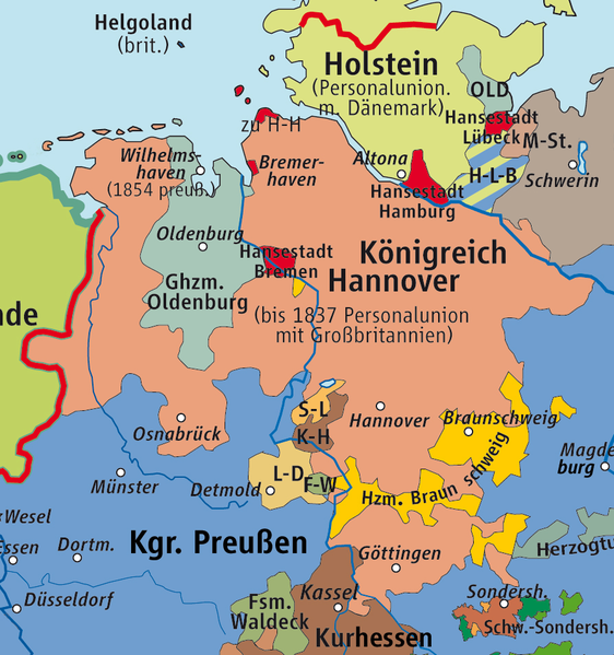
Deutsch: Karte des »Königreichs Hannover« 1815–1866 – basierend auf Karte des »Deutschen Bundes« 1815–1866 von kgberger
English: Map of Kingdom of Hanover 1815–1866, based on Map of German Confederation 1815–1866 by kgberger. |
||||||||
| Datum | |||||||||
| Boarne | own drawing/Source of Information: Putzger – Historischer Weltatlas, 89. Auflage, 1965 | ||||||||
| Auteur | kgberger | ||||||||
| Tastimming (Reusing this file) |
I, the copyright holder of this work, hereby publish it under the following licenses:
This file is licensed under the Creative Commons Attribution 2.5 Generic license.
You may select the license of your choice. |


|
This historical map image could be re-created using vector graphics as an SVG file. This has several advantages; see Commons:Media for cleanup for more information. If an SVG form of this image is available, please upload it and afterwards replace this template with
{{vector version available|new image name}}.
It is recommended to name the SVG file “KrkHannover.svg”—then the template Vector version available (or Vva) does not need the new image name parameter. |
Triemskiednis
Klik op in datum/tiid om it bestân te besjen sa't it op dat stuit wie.
| Datum/Tiid | Miniatuer | ôfmjittings | Meidogger | Opmerking | |
|---|---|---|---|---|---|
| lêste | 25 aug 2015, 14.49 | | 894 × 953 (535 KB) | RokerHRO | optipng -zc1-9 -zm1-9 -zs0-3 -f0-5 → 7.70% decrease |
| 11 okt 2010, 14.58 |  | 894 × 953 (580 KB) | Ziegelbrenner | 2010-10-11 | |
| 12 feb 2007, 19.03 |  | 894 × 953 (544 KB) | Ziegelbrenner | ||
| 1 feb 2007, 20.52 |  | 964 × 944 (802 KB) | Ziegelbrenner | == Summary == * Description: Karte des »Königreichs Hannover« 1815–1866 / Map of »Kingdom of Hannover« 1815–1866 – Based on Karte des »Deutschen Bundes« 1815–1866 / Map of »German Confederation« 1815–1866 by [[:de:Benutzer:kgberger|kgb | |
| 22 des 2006, 14.21 |  | 914 × 914 (640 KB) | Känsterle~commonswiki | Kingdom of Hanover in the German Confederation Based on Deutscher Bund.png by de:Benutzer:Kgberger |
Bestânsgebrûk
De neikommende 2 siden brûke dit bestân:
Globaal bestânsgebrûk
De neikommende oare wiki's brûke dit bestân:
- Gebrûk op af.wikipedia.org
- Gebrûk op an.wikipedia.org
- Gebrûk op ar.wikipedia.org
- Gebrûk op arz.wikipedia.org
- Gebrûk op azb.wikipedia.org
- Gebrûk op bg.wikipedia.org
- Gebrûk op br.wikipedia.org
- Gebrûk op da.wikipedia.org
- Gebrûk op de.wikipedia.org
- Niedersachsen
- Landkreis Emsland
- Grafschaft Bentheim
- Lingen (Ems)
- Niedersachsenlied
- Geschichte Ostfrieslands
- Wikipedia:Kartenwerkstatt/Kartenwünsche
- Königreich Hannover
- Institut für Historische Landesforschung
- Liste der Gebietsänderungen in Niedersachsen
- Wahlrecht in den deutschen Einzelstaaten bis 1918
- Benutzer:Ziegelbrenner/Meine Bilder auf Commons
- Benutzer:Aeroid/Königreich Hannover Administrative Objekte
- Niedersächsische Bibliographie
- Gebrûk op en.wikipedia.org
- Gebrûk op eo.wikipedia.org
- Gebrûk op es.wikipedia.org
- Gebrûk op et.wikipedia.org
- Gebrûk op eu.wikipedia.org
- Gebrûk op id.wikipedia.org
- Gebrûk op it.wikipedia.org
- Gebrûk op ka.wikipedia.org
- Gebrûk op la.wikipedia.org
- Gebrûk op li.wikipedia.org
- Gebrûk op lt.wikipedia.org
- Gebrûk op lv.wikipedia.org
- Gebrûk op mk.wikipedia.org
- Gebrûk op nds-nl.wikipedia.org
Mear globaal gebrûk fan dit bestân besjen.