
Ofbyld:Kingdom of Mercia.png

Oarspronklik bestân (1.278 × 1.373 pixels, bestânsgrutte: 124 KB, MIME-type: image/png)
Gearfetting
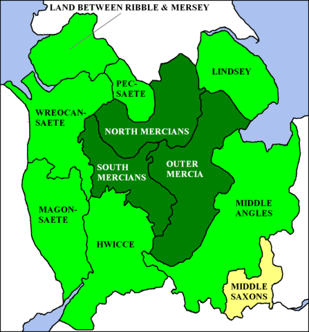
a Map of Kingdom of Mercia, England. from en:wp, [1].
Lisinsje
| This file is licensed under the Creative Commons Attribution-Share Alike 3.0 Unported license. Subject to disclaimers. | ||
| ||
| This licensing tag was added to this file as part of the GFDL licensing update. |

|
Der wurdt tastimming jûn ta kopiearjen, fersprieden en/of wizigjen fan dit dokumint ûnder de betinksten fan de GNU-lisinsje foar iepen dokumintaasje, ferzje 1.2, as eltse lettere ferzje útjûn troch de Free Software Foundation; sûnder Ynfariante Seksjes, sûnder Omkaftteksten foar de Foarkante en sûnder Omkaftteksten foar de Efterkante. In kopy fan de lisinsje is opnaam yn de seksje "Text of the GNU Free Documentation License". Subject to disclaimers. |
| Beskriuwing | I created this image. The en:Kingdom of Mercia at its greatest extent (7th to 9th centuries) is shown in green, with the original core area (6th century) given a darker tint. TharkunColl 16:23, 6 June 2006 (UTC) |
| Datum | 6 juny 2006 (original upload date) |
| Boarne | Transferred from en.wikipedia to Commons. |
| Auteur | TharkunColl at Ingelsk Wikipedy |

|
This historical map image could be re-created using vector graphics as an SVG file. This has several advantages; see Commons:Media for cleanup for more information. If an SVG form of this image is available, please upload it and afterwards replace this template with
{{vector version available|new image name}}.
It is recommended to name the SVG file “Kingdom of Mercia.svg”—then the template Vector version available (or Vva) does not need the new image name parameter. |
Lisinsje
|
NOTE: "subject to disclaimers" below may not actually apply, this was tagged with {{GFDL-user-en}}, and after May 2007, en:Template:GFDL-self did not require disclaimers. Please check the image description page on the English Wikipedia (or, if it has been deleted, ask an English Wikipedia administrator). See Wikipedia:GFDL standardization for details. | ||||||||
TharkunColl from en.wikipedia.org, the copyright holder of this work, hereby publishes it under the following license:
| ||||||||
|
Note: This tag should not be used. For images that were released on the English Wikipedia using either GFDL or GFDL-self with disclaimers, use {{GFDL-user-en-with-disclaimers}}. For images without disclaimers please use {{GFDL-user-en-no-disclaimers}} instead. If you are the copyright holder of files that were released on Wikipedia, please consider removing the disclaimers. |

![[1]](https://en.wikipedia.org/wiki/Image:Kingdom_of_Mercia.png)
Original upload log
- 2006-06-06 16:19 TharkunColl 404×505×8 (126328 bytes) I created this image.
Triemskiednis
Klik op in datum/tiid om it bestân te besjen sa't it op dat stuit wie.
| Datum/Tiid | Miniatuer | ôfmjittings | Meidogger | Opmerking | |
|---|---|---|---|---|---|
| lêste | 13 okt 2012, 14.37 | | 1.278 × 1.373 (124 KB) | Jaybear | Sea-areas colored in lightblue; |
| 15 jun 2009, 13.21 |  | 1.278 × 1.373 (104 KB) | Filipo | {{ShouldBeSVG|map}} Created by en:User:TharkunColl for English Wikipedia. The Kingdom of Mercia at its greatest extent (7th to 9th centuries) is shown in green, with the original core area (6th century) given a darker tint. {{GFDL-user-w|en|En | |
| 7 jun 2006, 07.06 |  | 404 × 505 (123 KB) | S kitahashi | a Map of Kingdom of Mercia, England. Mercia |
Bestânsgebrûk
De neikommende side brûkt dit bestân:
Globaal bestânsgebrûk
De neikommende oare wiki's brûke dit bestân:
- Gebrûk op be-tarask.wikipedia.org
- Gebrûk op be.wikipedia.org
- Gebrûk op ca.wikipedia.org
- Gebrûk op cy.wikipedia.org
- Gebrûk op da.wikipedia.org
- Gebrûk op de.wikipedia.org
- Gebrûk op el.wikipedia.org
- Gebrûk op en.wikipedia.org
- Gebrûk op eo.wikipedia.org
- Gebrûk op es.wikipedia.org
- Gebrûk op eu.wikipedia.org
- Gebrûk op ga.wikipedia.org
- Gebrûk op gl.wikipedia.org
- Gebrûk op it.wikipedia.org
- Gebrûk op ja.wikipedia.org
- Gebrûk op la.wikipedia.org
- Gebrûk op nds.wikipedia.org
- Gebrûk op nl.wikipedia.org
- Gebrûk op nn.wikipedia.org
- Gebrûk op no.wikipedia.org
- Gebrûk op ro.wikipedia.org
- Gebrûk op sh.wikipedia.org
- Gebrûk op simple.wikipedia.org
- Gebrûk op th.wikipedia.org
- Gebrûk op uk.wikipedia.org
- Gebrûk op zh.wikipedia.org