
Ofbyld:Karte Insel Usedom.png
Grutte fan dit proefbyld: 654 × 600 piksels. Oare resolúsjes: 262 × 240 piksels | 524 × 480 piksels | 838 × 768 piksels | 1.153 × 1.057 piksels.
Oarspronklik bestân (1.153 × 1.057 pixels, bestânsgrutte: 458 KB, MIME-type: image/png)

|
This map image could be re-created using vector graphics as an SVG file. This has several advantages; see Commons:Media for cleanup for more information. If an SVG form of this image is available, please upload it and afterwards replace this template with
{{vector version available|new image name}}.
It is recommended to name the SVG file “Karte Insel Usedom.svg”—then the template Vector version available (or Vva) does not need the new image name parameter. |
Gearfetting
| Beskriuwing |
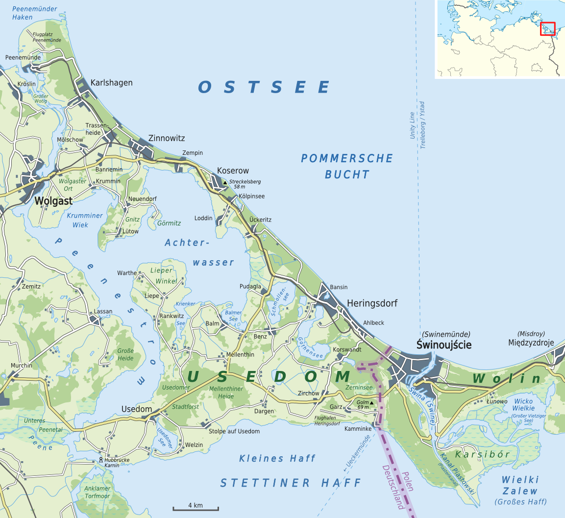
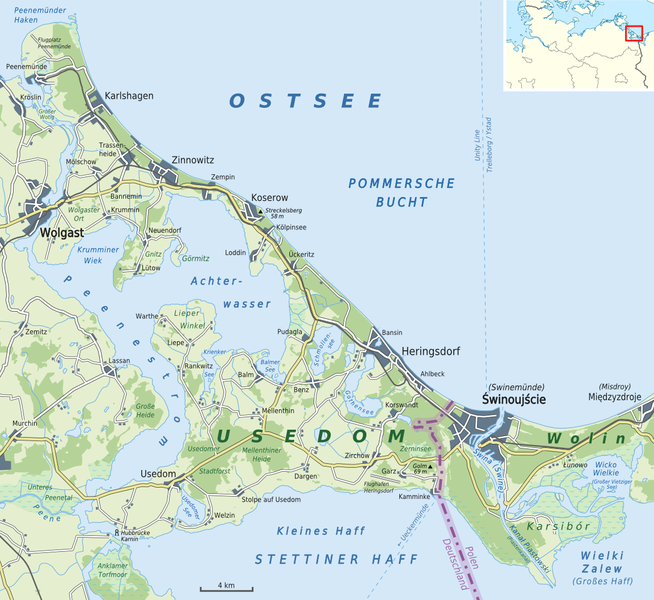
Deutsch: Karte von der Insel Usedom mit den wichtigsten Gemeinden
English: Map of Usedom Island with its most important municipalities |
| Datum | |
| Boarne |
Eigen wurk |
| Auteur | Alexrk2 |
| Oare ferzjes |
.png)

|
This map has been made or improved in the German Kartenwerkstatt (Map Lab). You can propose maps to improve as well.
|
Lisinsje
I, the copyright holder of this work, hereby publish it under the following license:
This file is licensed under the Creative Commons Attribution-Share Alike 3.0 Unported license.
- Fiel jo frij:
- te dielen – it wurk te kopiearjen, fersprieden en út te stjoeren
- te fermingen – it wurk oan te passen
- Under de neikommende betingsten:
- Nammefermelding – You must give appropriate credit, provide a link to the license, and indicate if changes were made. You may do so in any reasonable manner, but not in any way that suggests the licensor endorses you or your use.
- Lyk diele – If you remix, transform, or build upon the material, you must distribute your contributions under the same or compatible license as the original.
Triemskiednis
Klik op in datum/tiid om it bestân te besjen sa't it op dat stuit wie.
| Datum/Tiid | Miniatuer | ôfmjittings | Meidogger | Opmerking | |
|---|---|---|---|---|---|
| lêste | 8 jun 2015, 00.36 | | 1.153 × 1.057 (458 KB) | Cmdrjameson | Compressed with pngout. Reduced by 224kB (32% decrease). |
| 3 aug 2011, 17.13 |  | 1.153 × 1.057 (682 KB) | Alexrk2 | - | |
| 19 jul 2011, 18.44 |  | 1.170 × 1.072 (694 KB) | Alexrk2 | Hubbrücke Karnin | |
| 17 jul 2011, 18.38 |  | 1.172 × 1.074 (694 KB) | Alexrk2 | Ueckermünde, Wielki Zalew | |
| 17 jul 2011, 14.47 |  | 1.170 × 1.072 (693 KB) | Alexrk2 | colors | |
| 17 jul 2011, 14.02 |  | 1.160 × 1.063 (687 KB) | Alexrk2 | color | |
| 17 jul 2011, 13.51 |  | 1.153 × 1.057 (681 KB) | Alexrk2 | == {{int:filedesc}} == {{Information |Description= {{de|Karte von Usedom}} {{en|Map of Usedom}} |Source={{Own}} * [http://www.openstreetmap.org Openstreetmap] data |Date=2011-07 |Author=Alexrk2 |Perm |
Bestânsgebrûk
De neikommende side brûkt dit bestân:
Globaal bestânsgebrûk
De neikommende oare wiki's brûke dit bestân:
- Gebrûk op an.wikipedia.org
- Gebrûk op ar.wikipedia.org
- Gebrûk op arz.wikipedia.org
- Gebrûk op az.wikipedia.org
- Gebrûk op br.wikipedia.org
- Gebrûk op ca.wikipedia.org
- Gebrûk op ceb.wikipedia.org
- Gebrûk op cs.wikipedia.org
- Gebrûk op da.wikipedia.org
- Gebrûk op de.wikipedia.org
- Gebrûk op el.wikipedia.org
- Gebrûk op en.wikipedia.org
- Gebrûk op es.wikipedia.org
- Gebrûk op eu.wikipedia.org
- Gebrûk op frr.wikipedia.org
- Gebrûk op fr.wikipedia.org
- Gebrûk op gl.wikipedia.org
- Gebrûk op hr.wikipedia.org
- Gebrûk op hu.wikipedia.org
- Gebrûk op id.wikipedia.org
- Gebrûk op ka.wikipedia.org
- Gebrûk op ko.wikipedia.org
- Gebrûk op mk.wikipedia.org
- Gebrûk op nl.wikipedia.org
- Gebrûk op no.wikipedia.org
- Gebrûk op pl.wikipedia.org
- Gebrûk op pt.wikipedia.org
- Gebrûk op ro.wikipedia.org
- Gebrûk op ru.wikipedia.org
- Gebrûk op sh.wikipedia.org
- Gebrûk op sv.wikipedia.org
Mear globaal gebrûk fan dit bestân besjen.