Ofbyld:Habsburg Map 1547.jpg
Page contents not supported in other languages.
Ut Wikipedy

Oarspronklik bestân(1.654 × 1.029 pixels, bestânsgrutte: 534 KB, MIME-type: image/jpeg)

Dit bestân komt fan Wikimedia Commons, en kin ek troch oare projekten brûkt wurde. De beskriuwing op syn bestânsside dêre wurdt hjirûnder werjûn.

Gearfetting

Beskriuwing
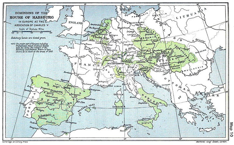
English: A map of the dominion of the Habsburgs following the Battle of Mühlberg (1547)
Datum
Boarne

The Cambridge Modern History Atlas, edited by Sir Adolphus William Ward, G.W. Prothero, Sir Stanley Mordaunt Leathes, and E.A. Benians. Cambridge University Press: London, 1912.

Editors were Sir Adolphus William Ward (†1924), G.W. Prothero (†1922), and Sir Stanley Mordaunt Leathes (†1938). Individual authors of works making up the atlas are not identified, nor are the likely to be, after reasonable research.
Auteur edited by Sir Adolphus William Ward, G.W. Prothero, Sir Stanley Mordaunt Leathes
Oare ferzjes

Lisinsje

Public domain
This work is in the public domain in the United States because it was published (or registered with the U.S. Copyright Office) before January 1, 1929.

Public domain works must be out of copyright in both the United States and in the source country of the work in order to be hosted on the Commons. If the work is not a U.S. work, the file must have an additional copyright tag indicating the copyright status in the source country.
Note: This tag should not be used for sound recordings.PD-1923Public domain in the United States//commons.wikimedia.org/wiki/File:Habsburg_Map_1547.jpg
Public domain logo
This UK artistic or literary work, of which the author is unknown and cannot be ascertained by reasonable enquiry, is in the public domain because it is one of the following:
  • A photograph, which has never previously been made available to the public (e.g. by publication or display at an exhibition) and which was taken more than 70 years ago (before 1 January 1954); or
  • A photograph, which was made available to the public (e.g. by publication or display at an exhibition) more than 70 years ago (before 1 January 1954); or
  • An artistic work other than a photograph (e.g. a painting), or a literary work, which was made available to the public (e.g. by publication or display at an exhibition) more than 70 years ago (before 1 January 1954).

Warning sign This tag can be used only when the author cannot be ascertained by reasonable enquiry. If you wish to rely on it, please specify in the image description the research you have carried out to find who the author was. The above is all subject to any overriding publication right which may exist. In practice, publication right will often override the first of the bullet points listed.

Unpublished anonymous paintings remain in copyright until at least 1 January 2040. This tag does not apply to engravings or musical works. More information

Captions

Add a one-line explanation of what this file represents

Items portrayed in this file

depicts Ingelsk

inception Ingelsk

1912

Triemskiednis

Klik op in datum/tiid om it bestân te besjen sa't it op dat stuit wie.

Datum/TiidMiniatuerôfmjittingsMeidoggerOpmerking
lêste29 mrt 2018, 11.20Miniatuer foar de ferzje fan 29 mrt 2018 om 11.201.654 × 1.029 (534 KB)Trecătorul răcitLittle add: borders of the time
3 sep 2015, 13.01Miniatuer foar de ferzje fan 3 sep 2015 om 13.011.654 × 1.029 (518 KB)KurzonReverted to version as of 17:22, 9 August 2010
29 jun 2013, 23.33Miniatuer foar de ferzje fan 29 jun 2013 om 23.331.654 × 1.029 (546 KB)CSvBibraadd more contrast per request by another user
9 aug 2010, 19.22Miniatuer foar de ferzje fan 9 aug 2010 om 19.221.654 × 1.029 (518 KB)CSvBibraPreviously put cleaned up version in new file with "b" after name. Now updating original file with "b" version. Both files uses throughout Wikipedias
28 aug 2008, 11.07Miniatuer foar de ferzje fan 28 aug 2008 om 11.071.654 × 1.029 (649 KB)F l a n k e rWrap, shadows and minor improvements
28 jun 2005, 16.42Miniatuer foar de ferzje fan 28 jun 2005 om 16.421.654 × 1.029 (421 KB)Rythin~commonswikiA map of the dominion of the Habsburgs following the Battle of Mühlberg (1547). Taken from ''The Cambridge Modern History Atlas,'' edited by Sir Adolphus William Ward, G.W. Prothero, Sir Stanley Mordaunt Leathes, and E.A. Benians. Cambridge University Pr

De neikommende side brûkt dit bestân:

Globaal bestânsgebrûk

De neikommende oare wiki's brûke dit bestân:

Mear globaal gebrûk fan dit bestân besjen.

Metadata