
Ofbyld:Gulf of Tonkin location.gif
Gjin hegere resolúsje beskikber.
Gulf_of_Tonkin_location.gif (500 × 500 pixels, bestânsgrutte: 90 KB, MIME-type: image/gif)

|
This locator map image could be re-created using vector graphics as an SVG file. This has several advantages; see Commons:Media for cleanup for more information. If an SVG form of this image is available, please upload it and afterwards replace this template with
{{vector version available|new image name}}.
It is recommended to name the SVG file “Gulf of Tonkin location.svg”—then the template Vector version available (or Vva) does not need the new image name parameter. |
| Beskriuwing |
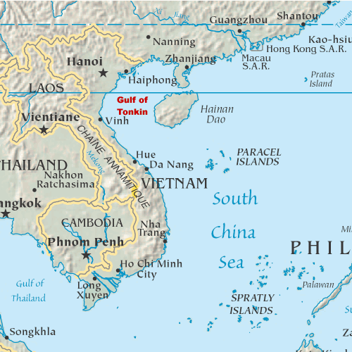
English: Map showing the location of the Gulf of Tonkin in the South China Sea |
||
| Datum | 31 oktober 2005 (original upload date) | ||
| Boarne | My original artwork based on a public domain map from the CIA World Factbook. | ||
| Auteur | The original uploader was DanMS at Ingelsk Wikipedy. | ||
| Tastimming (Reusing this file) |
|
Original upload log
The original description page was here. All following user names refer to en.wikipedia.
- 2005-11-02 16:39 DanMS 500×500× (92188 bytes) Map showing the location of the Gulf of Tonkin in the South China Sea. My original artwork based on a public domain map from the CIA World Factbook. This is a modification of my earlier file by the same name. {{pd-user|DanMS}}
- 2005-10-31 21:55 DanMS 500×500× (89358 bytes) Map showing the location of the Gulf of Tonkin in the South China Sea. My original artwork based on a public domain map from the CIA World Factbook. {{pd-user|DanMS}}
Triemskiednis
Klik op in datum/tiid om it bestân te besjen sa't it op dat stuit wie.
| Datum/Tiid | Miniatuer | ôfmjittings | Meidogger | Opmerking | |
|---|---|---|---|---|---|
| lêste | 15 mai 2010, 13.29 | | 500 × 500 (90 KB) | Urdangaray | {{Information |Description={{en|Map showing the location of the Gulf of Tonkin in the South China Sea. My original artwork based on a public domain map from the CIA World Factbook.}} |Source=Transferred from [http://en.wikipedia.org en.wikipedia] |Date={{ |
Bestânsgebrûk
De neikommende side brûkt dit bestân:
Globaal bestânsgebrûk
De neikommende oare wiki's brûke dit bestân:
- Gebrûk op af.wikipedia.org
- Gebrûk op ar.wikipedia.org
- Gebrûk op bg.wikipedia.org
- Gebrûk op bn.wikipedia.org
- Gebrûk op bs.wikipedia.org
- Gebrûk op cs.wikipedia.org
- Gebrûk op cy.wikipedia.org
- Gebrûk op de.wikipedia.org
- Gebrûk op en.wikipedia.org
- Gebrûk op es.wikipedia.org
- Gebrûk op fa.wikipedia.org
- Gebrûk op fi.wikipedia.org
- Gebrûk op fr.wikipedia.org
- Gebrûk op he.wikipedia.org
- Gebrûk op hi.wikipedia.org
- Gebrûk op hu.wikipedia.org
- Gebrûk op id.wikipedia.org
- Gebrûk op ilo.wikipedia.org
- Gebrûk op it.wikipedia.org
- Gebrûk op ja.wikipedia.org
- Gebrûk op km.wikipedia.org
- Gebrûk op ky.wikipedia.org
- Gebrûk op mk.wikipedia.org
- Gebrûk op nds-nl.wikipedia.org
- Gebrûk op nl.wikipedia.org
- Gebrûk op nn.wikipedia.org
- Gebrûk op pl.wikipedia.org
- Gebrûk op sh.wikipedia.org
- Gebrûk op sl.wikipedia.org
- Gebrûk op sr.wikipedia.org
- Gebrûk op th.wikipedia.org
- Gebrûk op ur.wikipedia.org
- Gebrûk op vi.wikipedia.org
- Gebrûk op war.wikipedia.org
- Gebrûk op zh.wikipedia.org