
Ofbyld:Frankish Empire 481 to 814-en.svg

Size of this PNG preview of this SVG file: 792 × 600 piksels. Oare resolúsjes: 317 × 240 piksels | 634 × 480 piksels | 1.014 × 768 piksels | 1.280 × 969 piksels | 2.560 × 1.939 piksels | 1.591 × 1.205 piksels.
Oarspronklik bestân (SVG-bestân, nominaal 1.591 × 1.205 pixels, bestânsgrutte: 834 KB)
Gearfetting
| Beskriuwing |
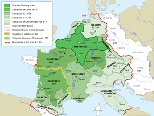
[] Afrikaans: Die veranderende strekking van die Frankiese Ryk van 481 tot 814. Alemannisch: S Frankeriich vo 481 bis 814. Bahasa Indonesia: Peta kebangkitan Kekaisaran Franka, dari tahun 481 hingga 814. Català: Mapa de l'expansió de l'Imperi Franc, de 481 a 814. Deutsch: Karte der Ausdehnung des Fränkischen Reichs 481 bis 814. English: Map of the rise of Frankish Empire, from 481 to 814. Español: Mapa de la expansión del Imperio Franco, entre 481 y 814. Euskara: Frankoen Inperioaren hedapenaren mapa, 481-814 urteen bitartean. Français : Carte de l'expansion de l'empire Franc, entre 481 et 814. Italiano: Carta dell'espansione dell'impero dei Franchi tra il 481 e il 814. Magyar: Frank Birodalom 481-814 Nederlands: Kaart van de opkomst van het Frankische Rijk, van 481 tot 814. Polski: Mapa rozwoju Imperium Franków w latach 481-814 Português: Mapa da expansão do Império Franco, entre 481 e 814. Română: Harta ascensiunii Imperiului franc, 481-814. Svenska: Karantanien i det frankiska riket (år 788 - 843). Ελληνικά: Η Φραγκική Αυτοκρατορία 481-814 Македонски: Карта на подемот на Франкското царство, од 481 до 814 г. Русский: Карта расширения империи франков, между 481 и 814. Українська: Карта розширення імперії Франків в період 481-814 рр. 日本語: カロリング朝の版図。 中文: 墨洛温王朝到加洛林王朝(481—814)的法兰克王国。 العربية : إمبراطوريَّة الفرنجة ما بين عاميّ 481 و814م |
| Datum | |
| Boarne |
Own work using:
|
| Auteur | Sémhur |
| Oare ferzjes |
Derivative works of this file: Frankish Empire 481 to 814-sr.svg
[]
|
| Camera location | | View this and other nearby images on: OpenStreetMap |
|---|

|
This SVG file contains embedded text that can be translated into your language, using any capable SVG editor, text editor or the SVG Translate tool. For more information see: About translating SVG files. |
This W3C-unspecified vector image was created with Inkscape .
Lisinsje
I, the copyright holder of this work, hereby publish it under the following licenses:
| Copyleft: This work of art is free; you can redistribute it and/or modify it according to terms of the Free Art License. You will find a specimen of this license on the Copyleft Attitude site as well as on other sites. |
This file is licensed under the Creative Commons Attribution-Share Alike 3.0 Unported, 2.5 Generic, 2.0 Generic and 1.0 Generic license.
- Fiel jo frij:
- te dielen – it wurk te kopiearjen, fersprieden en út te stjoeren
- te fermingen – it wurk oan te passen
- Under de neikommende betingsten:
- Nammefermelding – You must give appropriate credit, provide a link to the license, and indicate if changes were made. You may do so in any reasonable manner, but not in any way that suggests the licensor endorses you or your use.
- Lyk diele – If you remix, transform, or build upon the material, you must distribute your contributions under the same or compatible license as the original.
You may select the license of your choice.
Triemskiednis
Klik op in datum/tiid om it bestân te besjen sa't it op dat stuit wie.
| Datum/Tiid | Miniatuer | ôfmjittings | Meidogger | Opmerking | |
|---|---|---|---|---|---|
| lêste | 5 sep 2012, 20.10 | | 1.591 × 1.205 (834 KB) | Hel-hama | minor corrections |
| 5 sep 2012, 19.35 |  | 1.591 × 1.205 (844 KB) | Hel-hama | second attempt to upload file | |
| 2 sep 2012, 21.34 |  | 1.735 × 1.227 (331 KB) | Hel-hama | Reverted to version as of 05:50, 7 May 2012 | |
| 2 sep 2012, 21.30 |  | 1.796 × 1.796 (973 KB) | Hel-hama | General improvements to map to make it more easy to read. | |
| 7 mai 2012, 07.50 |  | 1.735 × 1.227 (331 KB) | Oosh | Fixed discrepancy between colours used in 481 Territory and Legend. Increased the blue channel in 714-768 Conquests for better contrast against 481-511 conquests. -~~~~ | |
| 15 okt 2007, 16.41 |  | 1.735 × 1.227 (331 KB) | Sémhur | {{Information |Description=Map of the rise of Frankish Empire, from 481 to 814. |Source=Own work, from Image:Frankish empire.jpg. |Date=2007-10-15 |Author= Sémhur ·<font size="4" color="forestgreen">[[:fr:Special:Emailuser/Sémhur| |
Bestânsgebrûk
De neikommende 8 siden brûke dit bestân:
Globaal bestânsgebrûk
De neikommende oare wiki's brûke dit bestân:
- Gebrûk op ar.wikipedia.org
- Gebrûk op av.wikipedia.org
- Gebrûk op azb.wikipedia.org
- Gebrûk op az.wikipedia.org
- Gebrûk op bh.wikipedia.org
- Gebrûk op bn.wikipedia.org
- Gebrûk op bs.wikipedia.org
- Gebrûk op ceb.wikipedia.org
- Gebrûk op cs.wikipedia.org
- Gebrûk op da.wikipedia.org
- Gebrûk op en.wikipedia.org
- Charlemagne
- Europe
- 774
- 481
- History of Burgundy
- History of the European Union
- Carolingian Empire
- Austrasia
- Carantania
- Carolingian dynasty
- List of Frankish kings
- Frankish language
- Charles the Younger
- Portal:European Union
- Kingdom of Soissons
- Benveniste
- Saxon Wars
- History of Western civilization
- List of revolutions and rebellions
- Duchy of Franconia
- User talk:Trasamundo
- Frisian–Frankish wars
- Wikipedia:WikiProject Maps/Conventions/Historical maps
- Duchy of Thuringia
- Succession to the French throne
- User:Kazkaskazkasako/Books/History
- History of Metz
Mear globaal gebrûk fan dit bestân besjen.