
Ofbyld:France Pays bretons map.jpg
Grutte fan dit proefbyld: 756 × 599 piksels. Oare resolúsjes: 303 × 240 piksels | 606 × 480 piksels | 969 × 768 piksels | 1.280 × 1.015 piksels | 1.500 × 1.189 piksels.
Oarspronklik bestân (1.500 × 1.189 pixels, bestânsgrutte: 815 KB, MIME-type: image/jpeg)

|
Ofbyld:France Pays bretons map.svg is in fektorferzje fan dizze triem. As net fan sljochtere kwaliteit tsjinnet dizze brûkt te wurden yn plak fan dizze rasterôfbylding.
File:France Pays bretons map.jpg → File:France Pays bretons map.svg
Sjoch Help:SVG foar mear ynformaasje. |
 |
Gearfetting
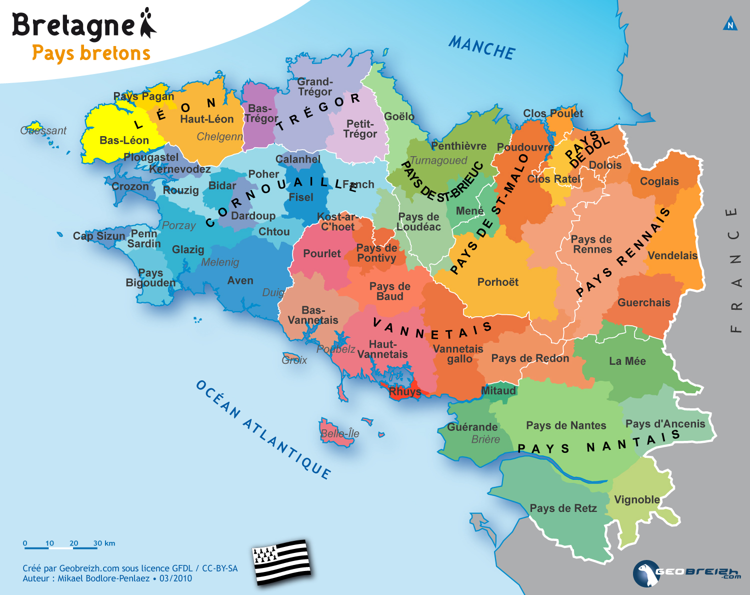
| Beskriuwing |
Brezhoneg: Kartenn broioù hengounel Breizh.
English: Map of the traditionnal regions of Brittany (France)
Français : Carte des pays traditionnels bretons. |
| Datum | |
| Boarne | http://www.geobreizh.com/breizh/fra/carte-pays-trad.asp |
| Auteur | Mikael Bodlore-Penlaez |
| Tastimming (Reusing this file) |
|
| Oare ferzjes |
[]
|


Lisinsje
I, the copyright holder of this work, hereby publish it under the following licenses:

|
Der wurdt tastimming jûn ta kopiearjen, fersprieden en/of wizigjen fan dit dokumint ûnder de betinksten fan de GNU-lisinsje foar iepen dokumintaasje, ferzje 1.2, as eltse lettere ferzje útjûn troch de Free Software Foundation; sûnder Ynfariante Seksjes, sûnder Omkaftteksten foar de Foarkante en sûnder Omkaftteksten foar de Efterkante. In kopy fan de lisinsje is opnaam yn de seksje "Text of the GNU Free Documentation License". |
This file is licensed under the Creative Commons Attribution-Share Alike Attribution-Share Alike 4.0 International, 3.0 Unported, 2.5 Generic, 2.0 Generic and 1.0 Generic license.
- Fiel jo frij:
- te dielen – it wurk te kopiearjen, fersprieden en út te stjoeren
- te fermingen – it wurk oan te passen
- Under de neikommende betingsten:
- Nammefermelding – You must give appropriate credit, provide a link to the license, and indicate if changes were made. You may do so in any reasonable manner, but not in any way that suggests the licensor endorses you or your use.
- Lyk diele – If you remix, transform, or build upon the material, you must distribute your contributions under the same or compatible license as the original.
You may select the license of your choice.
Triemskiednis
Klik op in datum/tiid om it bestân te besjen sa't it op dat stuit wie.
| Datum/Tiid | Miniatuer | ôfmjittings | Meidogger | Opmerking | |
|---|---|---|---|---|---|
| lêste | 31 mrt 2010, 14.59 | | 1.500 × 1.189 (815 KB) | Pethrus | {{Information |Description={{en|Map of the traditionnal regions of Bretagne (France)}}{{fr|Carte des pays traditionnels bretons}} |Source=[http://www.geobreizh.com www.geobreizh.com], Mikael Bodlore-Pentaez |Date=2010-03-30 |Author=Mikael Bodlore-Pentaez |
Bestânsgebrûk
Der binne gjin siden dy't dit bestân brûke.
Globaal bestânsgebrûk
De neikommende oare wiki's brûke dit bestân:
- Gebrûk op cy.wikipedia.org
- Gebrûk op de.wikipedia.org
- Gebrûk op fr.wikipedia.org
- Gebrûk op hu.wikipedia.org