
Ofbyld:Eastern Front 1941-06 to 1941-12.png

Grutte fan dit proefbyld: 783 × 600 piksels. Oare resolúsjes: 313 × 240 piksels | 627 × 480 piksels | 1.003 × 768 piksels | 1.201 × 920 piksels.
Oarspronklik bestân (1.201 × 920 pixels, bestânsgrutte: 330 KB, MIME-type: image/png)

|
This military map image could be re-created using vector graphics as an SVG file. This has several advantages; see Commons:Media for cleanup for more information. If an SVG form of this image is available, please upload it and afterwards replace this template with
{{vector version available|new image name}}.
It is recommended to name the SVG file “Eastern Front 1941-06 to 1941-12.svg”—then the template Vector version available (or Vva) does not need the new image name parameter. |
Gearfetting
| Beskriuwing |
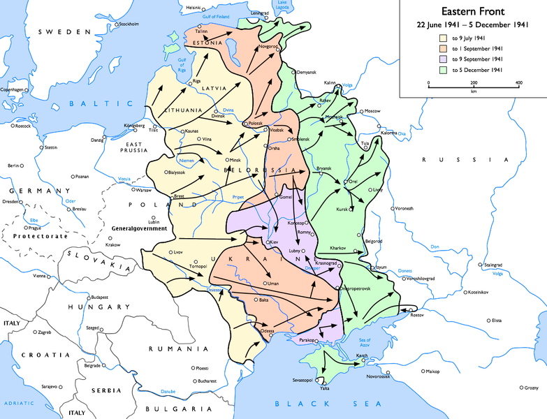
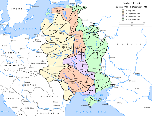
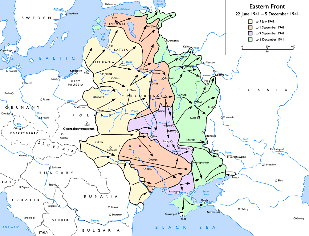
English: Map of the Eastern Front (WWII), 1941-06-21 to 1941-12-05
to 9 July 1941
to 1 September 1941
to 9 September 1941
to 5 December 1941 |
| Datum | |
| Boarne | Eigen wurk |
| Auteur | User:Gdr |
| Oare ferzjes |
[]
|


.png)


.jpg)
Lisinsje
Gdr from en.wikipedia.org, the copyright holder of this work, hereby publishes it under the following license:
| This file is licensed under the Creative Commons Attribution-Share Alike 3.0 Unported license. Subject to disclaimers. | ||
| Nammefermelding: Gdr from en.wikipedia.org | ||
| ||
| This licensing tag was added to this file as part of the GFDL licensing update. |

|
Der wurdt tastimming jûn ta kopiearjen, fersprieden en/of wizigjen fan dit dokumint ûnder de betinksten fan de GNU-lisinsje foar iepen dokumintaasje, ferzje 1.2, as eltse lettere ferzje útjûn troch de Free Software Foundation; sûnder Ynfariante Seksjes, sûnder Omkaftteksten foar de Foarkante en sûnder Omkaftteksten foar de Efterkante. In kopy fan de lisinsje is opnaam yn de seksje "Text of the GNU Free Documentation License". Subject to disclaimers. |
Original upload log
Transferred from en.wikipedia to Commons by Sdrtirs using CommonsHelper.
The original description page was here. All following user names refer to en.wikipedia.
- 2007-07-05 11:44 Mahahahaneapneap 1201×920×8 (243537 bytes) pngcrushed
- 2007-06-29 22:34 Forteblast 1201×920×8 (333192 bytes) Reverted to earlier revision
- 2006-09-30 10:57 Felix116 1201×920×8 (333192 bytes) Reverted to earlier revision
- 2006-09-30 10:56 Felix116 1201×920×8 (261858 bytes) Reverted to earlier revision
- 2006-03-10 14:20 Marskell 1201×920×8 (333192 bytes) Reverted to earlier revision
- 2006-03-10 14:20 Marskell 1201×920×8 (261858 bytes) Reverted to earlier revision
- 2005-12-16 13:45 Zocky 1201×920×8 (333192 bytes) edited by me for more distinct colours
- 2005-03-22 07:59 Gdr 1201×920×8 (261858 bytes) add advances to 1941-12
- 2005-03-22 02:14 Gdr 1201×921×8 (234615 bytes) oops, forgot to trim and compress
- 2005-03-22 02:08 Gdr 1201×922×8 (234664 bytes) fix scale, spelling of Breslau
- 2005-03-21 22:37 Gdr 1203×923×8 (265406 bytes) trim margins
- 2005-03-20 21:29 Gdr 1269×977×8 (345345 bytes) add scale, fix dates in key
- 2005-03-20 20:24 Gdr 1203×923×8 (263232 bytes) oops, forgot the Crimea
- 2005-03-20 20:04 Gdr 1203×923×8 (262950 bytes) Map of the [[Eastern Front (WWII)]], [[1941]]-[[06-21]] to [[1941]]-[[12-05]]{{GFDL}}Drawn by [[User:Gdr]]
Triemskiednis
Klik op in datum/tiid om it bestân te besjen sa't it op dat stuit wie.
| Datum/Tiid | Miniatuer | ôfmjittings | Meidogger | Opmerking | |
|---|---|---|---|---|---|
| lêste | 21 nov 2015, 23.31 | | 1.201 × 920 (330 KB) | Spiridon Ion Cepleanu | Borders of this time |
| 31 mrt 2010, 19.13 |  | 1.201 × 920 (265 KB) | DJ Sturm | ||
| 13 apr 2006, 02.58 |  | 1.201 × 920 (325 KB) | Bettachini~commonswiki | Author: Gdr, Wikipedia (EN) user Source: WP:EN — Eastern Front 1941-06 to 1941-12.png [SOURCE] Authorisation to use image by author: I uploaded the World War II maps to the | |
| 23 jul 2005, 20.18 |  | 1.201 × 920 (256 KB) | Get It | ;Description :Map of the Eastern Front (WWII), 1941-06-21 to 1941-12-05 ;Author :Gdr, Wikipedia (EN) user ;Source :Uploaded to WP:EN by the author (see below) ;License :{{ |
Bestânsgebrûk
De neikommende side brûkt dit bestân:
Globaal bestânsgebrûk
De neikommende oare wiki's brûke dit bestân:
- Gebrûk op af.wikipedia.org
- Gebrûk op ar.wikipedia.org
- Gebrûk op ast.wikipedia.org
- Gebrûk op azb.wikipedia.org
- Gebrûk op az.wikipedia.org
- Gebrûk op be-tarask.wikipedia.org
- Gebrûk op bg.wikipedia.org
- Gebrûk op bn.wikipedia.org
- Gebrûk op ca.wikipedia.org
- Gebrûk op ckb.wikipedia.org
- Gebrûk op cs.wikipedia.org
- Gebrûk op da.wikipedia.org
- Gebrûk op el.wikipedia.org
- Gebrûk op en.wikipedia.org
- Eastern Front (World War II)
- Battle of Moscow
- Pocket (military)
- User:Gdr/Gallery
- Battle of Rostov (1941)
- Reichskommissariat Moskowien
- Talk:Eastern Front (World War II)/Archive 2
- Byelorussia in World War II
- Military history of Latvia during World War II
- User:Drogo Underburrow/World War II
- User:TomStar81/World War II
- User:Vanished user 90345uifj983j4toi234k/World War II
- Resistance in Lithuania during World War II
- Talk:World War II/Archive 10
Mear globaal gebrûk fan dit bestân besjen.