
Ofbyld:Cincinnati.png

Grutte fan dit proefbyld: 800 × 483 piksels. Oare resolúsjes: 320 × 193 piksels | 640 × 386 piksels | 1.024 × 618 piksels | 1.280 × 772 piksels | 2.990 × 1.804 piksels.
Oarspronklik bestân (2.990 × 1.804 pixels, bestânsgrutte: 500 KB, MIME-type: image/png)
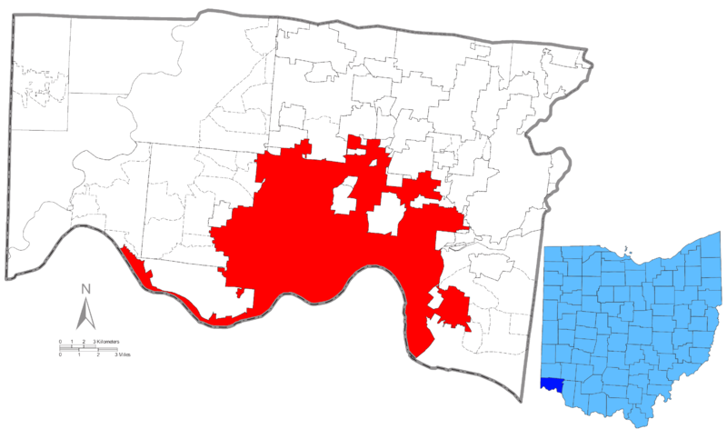
| Beskriuwing | Map of Hamilton County, Ohio highlighting Cincinnati with an inset map of Ohio highlighting Hamilton County. |
| Datum | 12/22/08 |
| Boarne | United States Census Bureau Source file |
| Auteur | §hep |
The source images are:
This image or file is a work of a United States Census Bureau employee, taken or made as part of that person's official duties. As a work of the U.S. federal government, the image is in the public domain.
|
 |
My modifications are:
I, the copyright holder of this work, hereby publish it under the following license:
This file is licensed under the Creative Commons Attribution-Share Alike 3.0 Unported license.
- Fiel jo frij:
- te dielen – it wurk te kopiearjen, fersprieden en út te stjoeren
- te fermingen – it wurk oan te passen
- Under de neikommende betingsten:
- Nammefermelding – You must give appropriate credit, provide a link to the license, and indicate if changes were made. You may do so in any reasonable manner, but not in any way that suggests the licensor endorses you or your use.
- Lyk diele – If you remix, transform, or build upon the material, you must distribute your contributions under the same or compatible license as the original.
Triemskiednis
Klik op in datum/tiid om it bestân te besjen sa't it op dat stuit wie.
| Datum/Tiid | Miniatuer | ôfmjittings | Meidogger | Opmerking | |
|---|---|---|---|---|---|
| lêste | 22 des 2008, 21.39 | | 2.990 × 1.804 (500 KB) | Stepshep | {{Information |Description= Map of Hamilton County, Ohio highlighting Cincinnati with an inset map of Ohio highlighting Hamilton County |Source= United States Census Bureau [http://www2.census.gov |
Bestânsgebrûk
Der binne gjin siden dy't dit bestân brûke.
Globaal bestânsgebrûk
De neikommende oare wiki's brûke dit bestân:
- Gebrûk op en.wikipedia.org
- Gebrûk op fo.wikipedia.org
- Gebrûk op fr.wikipedia.org
- Gebrûk op kw.wikipedia.org
- Gebrûk op ms.wikipedia.org
- Gebrûk op nn.wikipedia.org
- Gebrûk op no.wikipedia.org
- Gebrûk op pt.wikipedia.org
- Gebrûk op ro.wikipedia.org
- Gebrûk op sv.wikipedia.org