
Ofbyld:CapeHornDetailMap.png
Grutte fan dit proefbyld: 800 × 482 piksels. Oare resolúsjes: 320 × 193 piksels | 640 × 386 piksels | 906 × 546 piksels.
Oarspronklik bestân (906 × 546 pixels, bestânsgrutte: 91 KB, MIME-type: image/png)
Gearfetting
| Beskriuwing |
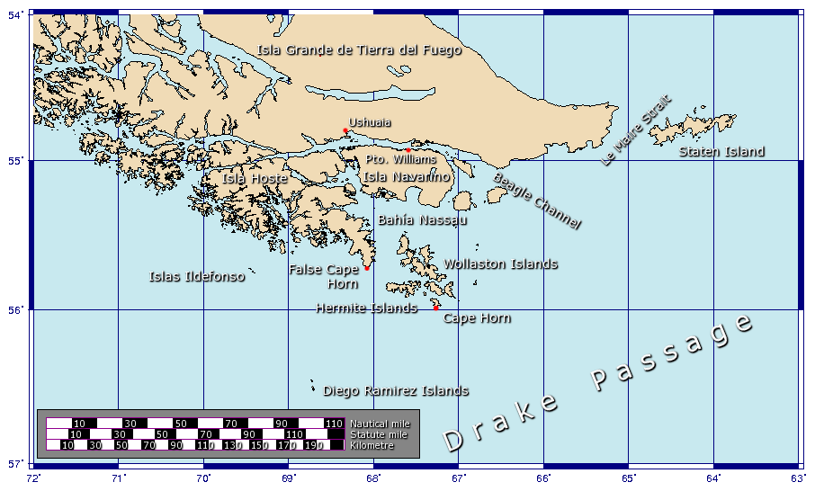
Español: Detalle de las islas cerca del Cabo de Hornos
Generated using GMT. |
| Datum | 27 jannewaris 2006 (original upload date) |
| Boarne | Eigen wurk |
| Auteur | Johantheghost |
Lisinsje
I, the copyright holder of this work, hereby publish it under the following licenses:

|
Der wurdt tastimming jûn ta kopiearjen, fersprieden en/of wizigjen fan dit dokumint ûnder de betinksten fan de GNU-lisinsje foar iepen dokumintaasje, ferzje 1.2, as eltse lettere ferzje útjûn troch de Free Software Foundation; sûnder Ynfariante Seksjes, sûnder Omkaftteksten foar de Foarkante en sûnder Omkaftteksten foar de Efterkante. In kopy fan de lisinsje is opnaam yn de seksje "Text of the GNU Free Documentation License". |
| This file is licensed under the Creative Commons Attribution-Share Alike 3.0 Unported license. | ||
| ||
| This licensing tag was added to this file as part of the GFDL licensing update. |
This file is licensed under the Creative Commons Attribution-Share Alike 2.5 Generic, 2.0 Generic and 1.0 Generic license.
- Fiel jo frij:
- te dielen – it wurk te kopiearjen, fersprieden en út te stjoeren
- te fermingen – it wurk oan te passen
- Under de neikommende betingsten:
- Nammefermelding – You must give appropriate credit, provide a link to the license, and indicate if changes were made. You may do so in any reasonable manner, but not in any way that suggests the licensor endorses you or your use.
- Lyk diele – If you remix, transform, or build upon the material, you must distribute your contributions under the same or compatible license as the original.
You may select the license of your choice.
Triemskiednis
Klik op in datum/tiid om it bestân te besjen sa't it op dat stuit wie.
| Datum/Tiid | Miniatuer | ôfmjittings | Meidogger | Opmerking | |
|---|---|---|---|---|---|
| lêste | 21 nov 2009, 18.17 | | 906 × 546 (91 KB) | Botaurus | functionless line (borderline) removed |
| 9 feb 2006, 14.22 |  | 906 × 546 (91 KB) | Johantheghost | Less violent colours. | |
| 28 jan 2006, 02.25 |  | 906 × 546 (90 KB) | Johantheghost | Fix scale! | |
| 27 jan 2006, 22.20 |  | 906 × 546 (87 KB) | Johantheghost | Scale and false cape | |
| 27 jan 2006, 18.34 |  | 906 × 546 (81 KB) | Johantheghost | A map showing the location of Cape Horn, including part of the Drake Passage. Generated using [http://gmt.soest.hawaii.edu/ GMT]. |
Bestânsgebrûk
De neikommende 3 siden brûke dit bestân:
Globaal bestânsgebrûk
De neikommende oare wiki's brûke dit bestân:
- Gebrûk op af.wikipedia.org
- Gebrûk op als.wikipedia.org
- Gebrûk op ar.wikipedia.org
- Gebrûk op ast.wikipedia.org
- Gebrûk op az.wikipedia.org
- Gebrûk op be-tarask.wikipedia.org
- Gebrûk op be.wikipedia.org
- Gebrûk op bg.wikipedia.org
- Gebrûk op br.wikipedia.org
- Gebrûk op bs.wikipedia.org
- Gebrûk op ca.wikipedia.org
- Gebrûk op ceb.wikipedia.org
- Gebrûk op ckb.wikipedia.org
- Gebrûk op cy.wikipedia.org
- Gebrûk op da.wikipedia.org
- Gebrûk op de.wikipedia.org
- Gebrûk op el.wikipedia.org
- Gebrûk op en.wikipedia.org
- Gebrûk op eo.wikipedia.org
- Gebrûk op es.wikipedia.org
- Gebrûk op et.wikipedia.org
- Gebrûk op eu.wikipedia.org
- Gebrûk op fa.wikipedia.org
- Gebrûk op fi.wikipedia.org
- Gebrûk op frr.wikipedia.org
- Gebrûk op fr.wikipedia.org
Mear globaal gebrûk fan dit bestân besjen.