
Ofbyld:Bombaymapconfirmed attacks.png

Grutte fan dit proefbyld: 577 × 600 piksels. Oare resolúsjes: 231 × 240 piksels | 462 × 480 piksels | 905 × 941 piksels.
Oarspronklik bestân (905 × 941 pixels, bestânsgrutte: 222 KB, MIME-type: image/png)
| Beskriuwing |
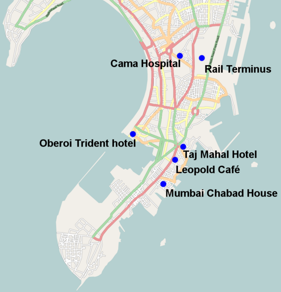
English: Map of the fairly solidly confirmed locations of the 26 November 2008 Mumbai attacks except Vile Parle suburb which is too vague and the port attack which again is still unclear also missing is the police station where it is unclear which one came under attack |
| Datum | |
| Boarne | open streetmaps with modifications http://www.openstreetmap.org/?lat=19.0072&lon=72.865&zoom=12&layers=B000FTFT |
| Auteur | user:geni open street maps |
| Tastimming (Reusing this file) |
Creative Commons Attribution-ShareAlike 2.0 |
| Beskriuwing | Map of Mumbai. This map may be incomplete, and may contain errors. Don't rely solely on it for navigation. |
| Datum | See file history |
| Boarne | OpenStreetMap data |
| Auteur | OpenStreetMap contributors |
| Tastimming (Reusing this file) |
All OpenStreetMap data and maps are Creative Commons "CC-BY-SA 2.0" licensed. This file is licensed under the Creative Commons Attribution-Share Alike 2.0 Generic license.
|
Triemskiednis
Klik op in datum/tiid om it bestân te besjen sa't it op dat stuit wie.
| Datum/Tiid | Miniatuer | ôfmjittings | Meidogger | Opmerking | |
|---|---|---|---|---|---|
| lêste | 28 nov 2008, 04.13 | | 905 × 941 (222 KB) | Geni | {{Information |Description={{en|1=Map of the fairly solidly confimed locations of the 26 November 2008 Mumbai attacks except Vile Parle suburb which is too vague and the port attack which again is still unclear}} |Source=open streetmaps with modifications |
Bestânsgebrûk
De neikommende 3 siden brûke dit bestân:
Globaal bestânsgebrûk
De neikommende oare wiki's brûke dit bestân:
- Gebrûk op ar.wikipedia.org
- Gebrûk op ckb.wikipedia.org
- Gebrûk op da.wikipedia.org
- Gebrûk op de.wikipedia.org
- Gebrûk op en.wikipedia.org
- Gebrûk op en.wikinews.org
- Gebrûk op fa.wikipedia.org
- Gebrûk op he.wikipedia.org
- Gebrûk op hi.wikipedia.org
- Gebrûk op ja.wikipedia.org
- Gebrûk op kn.wikipedia.org
- Gebrûk op li.wikipedia.org
- Gebrûk op mai.wikipedia.org
- Gebrûk op ml.wikipedia.org
- Gebrûk op nl.wikipedia.org
- Gebrûk op pa.wikipedia.org
- Gebrûk op simple.wikipedia.org
- Gebrûk op tr.wikipedia.org
- Gebrûk op uk.wikipedia.org
- Gebrûk op zh.wikinews.org