
Ofbyld:Besancon map with districts numbers.svg

Size of this PNG preview of this SVG file: 511 × 600 piksels. Oare resolúsjes: 204 × 240 piksels | 409 × 480 piksels | 654 × 768 piksels | 872 × 1.024 piksels | 1.744 × 2.048 piksels | 701 × 823 piksels.
Oarspronklik bestân (SVG-bestân, nominaal 701 × 823 pixels, bestânsgrutte: 2,46 MB)
Gearfetting
| Beskriuwing |
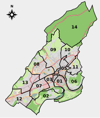
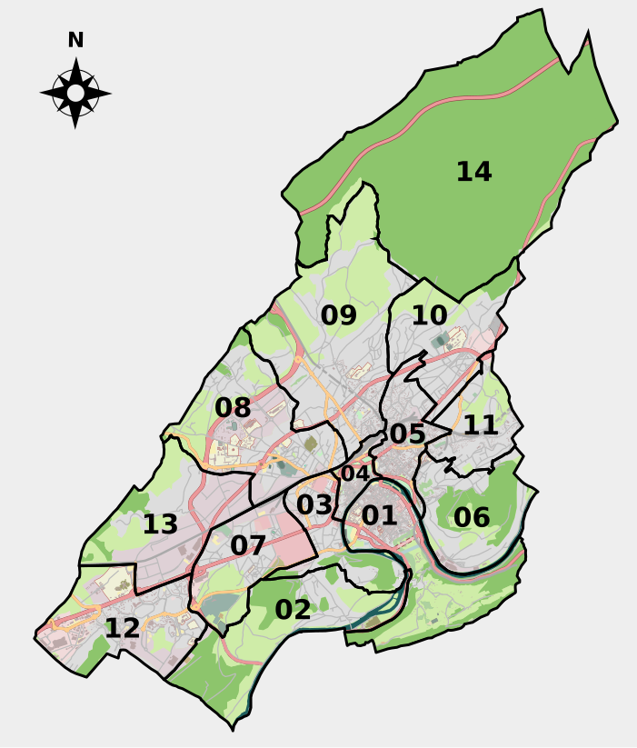
Français : Carte de Besançon comprenant la délimitation des 14 grands quartiers de la ville. Les limites des quartiers sont tracées sur un calque séparé et peuvent donc être facilement supprimée, modifiées ou coloriées. Les couleurs utilisées sont celles d'OpenStreetMap, à l'exception d'une uniformisation des zones non-construites en vert clair et d'une coloration bleue/grise pour les zones de sport/loisir.
English: Map of the French city of Besançon with its 14 districts. Districts area are drawn on a separate layer in order to be easily removed, modified or colorized. Map colors follow OSM color code except for non-built areas (all in light green here) and sport areas (blue-grey here). |
| Datum | |
| Boarne | Own work based on: Besancon map with districts.svg by Wikipedro |
| Auteur | Pethrus |
| SVG genesis |

Lisinsje
I, the copyright holder of this work, hereby publish it under the following license:
This file is licensed under the Creative Commons Attribution-Share Alike 2.0 Generic license.
- Fiel jo frij:
- te dielen – it wurk te kopiearjen, fersprieden en út te stjoeren
- te fermingen – it wurk oan te passen
- Under de neikommende betingsten:
- Nammefermelding – You must give appropriate credit, provide a link to the license, and indicate if changes were made. You may do so in any reasonable manner, but not in any way that suggests the licensor endorses you or your use.
- Lyk diele – If you remix, transform, or build upon the material, you must distribute your contributions under the same or compatible license as the original.
Triemskiednis
Klik op in datum/tiid om it bestân te besjen sa't it op dat stuit wie.
| Datum/Tiid | Miniatuer | ôfmjittings | Meidogger | Opmerking | |
|---|---|---|---|---|---|
| lêste | 20 mai 2010, 12.28 | | 701 × 823 (2,46 MB) | Pethrus | {{Information |Description={{fr|Carte de Besançon comprenant la délimitation des 14 grands quartiers de la ville. Les limites des quartiers sont tracées sur un calque séparé et peuvent donc être facilement supprimée, modifiées ou coloriées. Les c |
Bestânsgebrûk
De neikommende side brûkt dit bestân:
Globaal bestânsgebrûk
De neikommende oare wiki's brûke dit bestân:
- Gebrûk op de.wikipedia.org
- Gebrûk op en.wikipedia.org
- Gebrûk op eo.wikipedia.org
- Gebrûk op eu.wikipedia.org
- Gebrûk op fr.wikipedia.org
- Gebrûk op it.wikipedia.org
- Gebrûk op nrm.wikipedia.org