
Ofbyld:Atlantikwall.png
Grutte fan dit proefbyld: 456 × 599 piksels. Oare resolúsjes: 183 × 240 piksels | 612 × 804 piksels.
Oarspronklik bestân (612 × 804 pixels, bestânsgrutte: 79 KB, MIME-type: image/png)

|
This military map image could be re-created using vector graphics as an SVG file. This has several advantages; see Commons:Media for cleanup for more information. If an SVG form of this image is available, please upload it and afterwards replace this template with
{{vector version available|new image name}}.
It is recommended to name the SVG file “Atlantikwall.svg”—then the template Vector version available (or Vva) does not need the new image name parameter. |
| Beskriuwing |
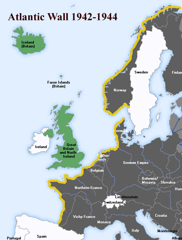
English: The Atlantic Wall (defence built by Nazi Germany, stood from 1942-44). Deutsch: Der Atlantikwall, eine 2.685 km lange Linie von befestigten Stellungen entlang der Küsten des Atlantiks, Ärmelkanals und der Nordsee, 1942-44. |
||||||||
| Datum | |||||||||
| Boarne | English Wikipedia, File:Atlantic-Wall.gif | ||||||||
| Auteur | User:Uberstroker | ||||||||
| Tastimming (Reusing this file) |
Uberstroker, the copyright holder of this work, hereby publishes it under the following license:
|
||||||||
| Oare ferzjes | [1] |

![[1]](https://en.wikipedia.org/wiki/Image:Atlantic-Wall.gif)
Original upload log
| Datum/Tiid | Ofmjittings | Meidogger | Opmerking |
|---|---|---|---|
| 14 april 2007, 01:54:16 | 612 × 804 (61489 bytes) | Responsible? (oerlis · bydragen) | {{Information |Description={{en|The '''Atlantic Wall''' (defence built by Nazi Germany, stood from 1942-44}} <br> {{de|Der '''Atlantikwall''', eine 2.685 km lange Linie von befestigten Stellungen entlang der Küsten des Atlantiks, Ärmelkanals und der Nor |
Triemskiednis
Klik op in datum/tiid om it bestân te besjen sa't it op dat stuit wie.
| Datum/Tiid | Miniatuer | ôfmjittings | Meidogger | Opmerking | |
|---|---|---|---|---|---|
| lêste | 19 apr 2015, 16.23 | | 612 × 804 (79 KB) | Hohum | Enhance blue |
| 19 sep 2014, 03.17 |  | 612 × 804 (80 KB) | Hohum | Clearer | |
| 18 aug 2014, 17.45 |  | 612 × 804 (65 KB) | GifTagger | Bot: Converting file to superior PNG file. (Source: Atlantikwall.gif). This GIF was problematic due to non-greyscale color table. |
Bestânsgebrûk
De neikommende side brûkt dit bestân:
Globaal bestânsgebrûk
De neikommende oare wiki's brûke dit bestân:
- Gebrûk op ar.wikipedia.org
- Gebrûk op azb.wikipedia.org
- Gebrûk op az.wikipedia.org
- Gebrûk op bg.wikipedia.org
- Gebrûk op bn.wikipedia.org
- Gebrûk op br.wikipedia.org
- Gebrûk op ca.wikipedia.org
- Gebrûk op da.wikipedia.org
- Gebrûk op diq.wikipedia.org
- Gebrûk op el.wikipedia.org
- Gebrûk op en.wikipedia.org
- Gebrûk op eo.wikipedia.org
- Gebrûk op et.wikipedia.org
- Gebrûk op eu.wikipedia.org
- Gebrûk op fa.wikipedia.org
- Gebrûk op fi.wikipedia.org
- Gebrûk op fr.wikipedia.org
- Gebrûk op hy.wikipedia.org
- Gebrûk op id.wikipedia.org
- Gebrûk op it.wikipedia.org
- Gebrûk op ja.wikipedia.org
- Gebrûk op ka.wikipedia.org
- Gebrûk op lv.wikipedia.org
- Gebrûk op mk.wikipedia.org
- Gebrûk op mr.wikipedia.org
- Gebrûk op ms.wikipedia.org
- Gebrûk op nl.wikipedia.org
- Gebrûk op nn.wikipedia.org
- Gebrûk op no.wikipedia.org
- Gebrûk op pt.wikipedia.org
- Gebrûk op ro.wikipedia.org
Mear globaal gebrûk fan dit bestân besjen.