
Ofbyld:Arkansas river basin map.png

Grutte fan dit proefbyld: 800 × 506 piksels. Oare resolúsjes: 320 × 202 piksels | 640 × 405 piksels | 1.200 × 759 piksels.
Oarspronklik bestân (1.200 × 759 pixels, bestânsgrutte: 1,46 MB, MIME-type: image/png)
Gearfetting
| Beskriuwing |
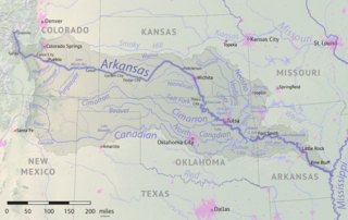
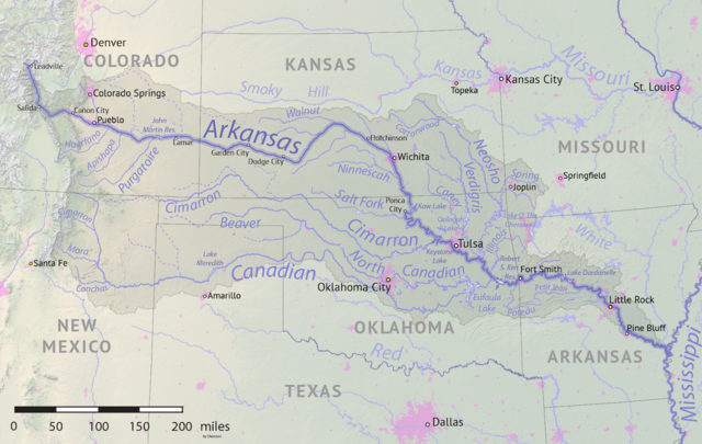
English: Map of the Arkansas River drainage basin. Created using USGS National Map and NASA SRTM data. |
| Datum | |
| Boarne | Eigen wurk |
| Auteur | Shannon1 |
Lisinsje
I, the copyright holder of this work, hereby publish it under the following licenses:

|
Der wurdt tastimming jûn ta kopiearjen, fersprieden en/of wizigjen fan dit dokumint ûnder de betinksten fan de GNU-lisinsje foar iepen dokumintaasje, ferzje 1.2, as eltse lettere ferzje útjûn troch de Free Software Foundation; sûnder Ynfariante Seksjes, sûnder Omkaftteksten foar de Foarkante en sûnder Omkaftteksten foar de Efterkante. In kopy fan de lisinsje is opnaam yn de seksje "Text of the GNU Free Documentation License". |
This file is licensed under the Creative Commons Attribution-Share Alike 4.0 International, 3.0 Unported, 2.5 Generic, 2.0 Generic and 1.0 Generic license.
- Fiel jo frij:
- te dielen – it wurk te kopiearjen, fersprieden en út te stjoeren
- te fermingen – it wurk oan te passen
- Under de neikommende betingsten:
- Nammefermelding – You must give appropriate credit, provide a link to the license, and indicate if changes were made. You may do so in any reasonable manner, but not in any way that suggests the licensor endorses you or your use.
- Lyk diele – If you remix, transform, or build upon the material, you must distribute your contributions under the same or compatible license as the original.
You may select the license of your choice.
Triemskiednis
Klik op in datum/tiid om it bestân te besjen sa't it op dat stuit wie.
| Datum/Tiid | Miniatuer | ôfmjittings | Meidogger | Opmerking | |
|---|---|---|---|---|---|
| lêste | 18 mai 2019, 19.41 | | 1.200 × 759 (1,46 MB) | Shannon1 | {{Information |description ={{en|1=Map of the Arkansas River drainage basin. Created using USGS National Map and NASA SRTM data.}} |date =2019-05-17 |source =Own work |author =Shannon1 }} Category:Arkansas River |
Bestânsgebrûk
De neikommende side brûkt dit bestân:
Globaal bestânsgebrûk
De neikommende oare wiki's brûke dit bestân:
- Gebrûk op af.wikipedia.org
- Gebrûk op azb.wikipedia.org
- Gebrûk op bg.wikipedia.org
- Gebrûk op bn.wikipedia.org
- Gebrûk op ceb.wikipedia.org
- Gebrûk op chy.wikipedia.org
- Gebrûk op cs.wikipedia.org
- Gebrûk op de.wikipedia.org
- Gebrûk op el.wikipedia.org
- Gebrûk op en.wikipedia.org
- Gebrûk op eo.wikipedia.org
- Gebrûk op es.wikipedia.org
- Arkansas
- Colorado Springs
- Little Rock (Arkansas)
- Wichita (Kansas)
- Tulsa
- Pueblo (Colorado)
- Río Arkansas
- Muskogee (Oklahoma)
- Fort Smith (Arkansas)
- Dodge City
- Pine Bluff
- Conway (Arkansas)
- Río Canadiano
- Río Canadian del Norte
- Río Neosho
- Coffeyville
- Garden City (Kansas)
- Great Bend (Kansas)
- Ratón (Nuevo México)
- Cañon City
- Woodward (Oklahoma)
- Guymon (Oklahoma)
- Enid (Oklahoma)
- Claremore (Oklahoma)
- Borger (Texas)
- Río Verdigris
- Gebrûk op et.wikipedia.org
- Gebrûk op frr.wikipedia.org
- Gebrûk op fr.wikipedia.org
- Gebrûk op gl.wikipedia.org
- Gebrûk op he.wikipedia.org
- Gebrûk op hu.wikipedia.org
- Gebrûk op incubator.wikimedia.org
Mear globaal gebrûk fan dit bestân besjen.