
Ofbyld:Amurrivermap.png

Grutte fan dit proefbyld: 761 × 599 piksels. Oare resolúsjes: 305 × 240 piksels | 610 × 480 piksels | 989 × 779 piksels.
Oarspronklik bestân (989 × 779 pixels, bestânsgrutte: 298 KB, MIME-type: image/png)
| Beskriuwing |
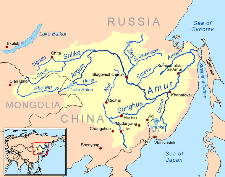
English: This is a map of the Amur River drainage basin. Русский: Карта бассейна реки Амур. |
| Datum | |
| Boarne | Own work using Digital Chart of the World and GTOPO data. |
| Auteur | Kmusser |
| Oare ferzjes |
Derivative works of this file: Amurriversourcesmap.jpg File:Amur watershed.png |
I, the copyright holder of this work, hereby publish it under the following license:
This file is licensed under the Creative Commons Attribution-Share Alike 3.0 Unported license.
- Fiel jo frij:
- te dielen – it wurk te kopiearjen, fersprieden en út te stjoeren
- te fermingen – it wurk oan te passen
- Under de neikommende betingsten:
- Nammefermelding – You must give appropriate credit, provide a link to the license, and indicate if changes were made. You may do so in any reasonable manner, but not in any way that suggests the licensor endorses you or your use.
- Lyk diele – If you remix, transform, or build upon the material, you must distribute your contributions under the same or compatible license as the original.

|
This map image could be re-created using vector graphics as an SVG file. This has several advantages; see Commons:Media for cleanup for more information. If an SVG form of this image is available, please upload it and afterwards replace this template with
{{vector version available|new image name}}.
It is recommended to name the SVG file “Amurrivermap.svg”—then the template Vector version available (or Vva) does not need the new image name parameter. |
Triemskiednis
Klik op in datum/tiid om it bestân te besjen sa't it op dat stuit wie.
| Datum/Tiid | Miniatuer | ôfmjittings | Meidogger | Opmerking | |
|---|---|---|---|---|---|
| lêste | 7 jun 2010, 03.15 | | 989 × 779 (298 KB) | Ras67 | cropped |
| 2 mrt 2009, 22.05 |  | 1.000 × 795 (367 KB) | Kmusser | {{Information |Description=This is a map of the Amur River drainage basin. |Source=Own work using [http://www.maproom.psu.edu/dcw/ Digital Chart of the World] and [http://edc.usgs.gov/products/elevation/gtopo30/gtopo30.html GTOPO] data. |
Bestânsgebrûk
De neikommende side brûkt dit bestân:
Globaal bestânsgebrûk
De neikommende oare wiki's brûke dit bestân:
- Gebrûk op af.wikipedia.org
- Gebrûk op als.wikipedia.org
- Gebrûk op ar.wikipedia.org
- Gebrûk op arz.wikipedia.org
- Gebrûk op ast.wikipedia.org
- Gebrûk op azb.wikipedia.org
- Gebrûk op be-tarask.wikipedia.org
- Gebrûk op bg.wikipedia.org
- Gebrûk op bh.wikipedia.org
- Gebrûk op bn.wikipedia.org
- Gebrûk op br.wikipedia.org
- Gebrûk op bs.wikipedia.org
- Gebrûk op ca.wikipedia.org
- Gebrûk op cy.wikipedia.org
- Gebrûk op da.wikipedia.org
- Gebrûk op de.wikipedia.org
- Gebrûk op en.wikipedia.org
- Gebrûk op eo.wikipedia.org
- Gebrûk op es.wikipedia.org
Mear globaal gebrûk fan dit bestân besjen.