
Ofbyld:Americas Köppen Map.png

Grutte fan dit proefbyld: 483 × 599 piksels. Oare resolúsjes: 193 × 240 piksels | 387 × 480 piksels | 619 × 768 piksels | 1.096 × 1.360 piksels.
Oarspronklik bestân (1.096 × 1.360 pixels, bestânsgrutte: 520 KB, MIME-type: image/png)
Gearfetting
| Beskriuwing |
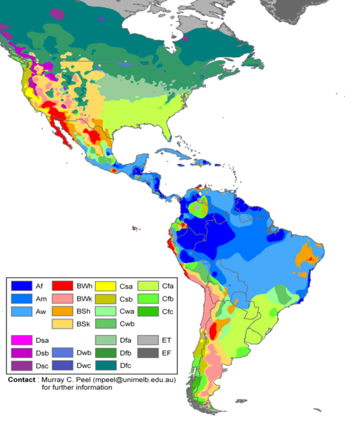
English: Edited Americas map of the Köppen-Geiger climate classification. The original was a world map JPG file which was converted to a smaller PNG file, without extra modifications, by Jeroen. The PNG file was further modified by WolfmanSF as follows: the map was cropped to reduce it to South America and most of North America; climate zone Dfa was changed to web color 99CC99, and climate zone Dfb was changed to web color 339933 (both shades of green); the color modifications to climate zones of temperate North America were intended to make the colors of tropical climate zones more distinctive, for use in articles on the Great American Interchange. The legend was rearranged, and climate zones Cwc, Dsd, Dwa, Dwd and Dfd were removed from the legend because they do not appear on this map. |
| Datum | |
| Boarne | Hydrology and Earth System Sciences: "Updated world map of the Köppen-Geiger climate classification" (Supplement) |
| Auteur |
Peel, M. C., Finlayson, B. L., and McMahon, T. A. (University of Melbourne) Citation: Peel, M. C., Finlayson, B. L., and McMahon, T. A.: Updated world map of the Köppen-Geiger climate classification, Hydrol. Earth Syst. Sci., 11, 1633-1644, 2007. |
| Oare ferzjes |
|

Lisinsje
This file is licensed under the Creative Commons Attribution-Share Alike 2.5 Generic license.
- Fiel jo frij:
- te dielen – it wurk te kopiearjen, fersprieden en út te stjoeren
- te fermingen – it wurk oan te passen
- Under de neikommende betingsten:
- Nammefermelding – You must give appropriate credit, provide a link to the license, and indicate if changes were made. You may do so in any reasonable manner, but not in any way that suggests the licensor endorses you or your use.
- Lyk diele – If you remix, transform, or build upon the material, you must distribute your contributions under the same or compatible license as the original.
Triemskiednis
Klik op in datum/tiid om it bestân te besjen sa't it op dat stuit wie.
| Datum/Tiid | Miniatuer | ôfmjittings | Meidogger | Opmerking | |
|---|---|---|---|---|---|
| lêste | 20 feb 2018, 21.20 | | 1.096 × 1.360 (520 KB) | Maphobbyist | The Costa Rican Central Valley has a dry winter oceanic climate (Köppen classification: Cwb). |
| 8 feb 2018, 02.19 |  | 1.096 × 1.360 (433 KB) | WolfmanSF | Reverted to version as of 10:48, 27 December 2008 (UTC) - the northernmost areas aren't of much interest for the purposes of the Great American Interchange article which uses this image | |
| 7 feb 2018, 23.30 |  | 1.860 × 1.593 (526 KB) | Maphobbyist | Included Alaska, Northern Canada and Greenland which were omitted. | |
| 27 des 2008, 12.48 |  | 1.096 × 1.360 (433 KB) | WolfmanSF | {{Information |Description= |Source= |Date= |Author= |Permission= |other_versions= }} | |
| 21 des 2008, 23.46 |  | 1.096 × 1.360 (439 KB) | WolfmanSF | rotate legend to make lettering horizontal; remove boxes for unused climate zones | |
| 5 mai 2008, 07.21 |  | 1.096 × 1.360 (428 KB) | WolfmanSF | {{Information |Description=Updated world map of the Köppen-Geiger climate classification. |Source=[http://www.hydrol-earth-syst-sci.net/11/1633/2007/hess-11-1633-2007.html Hydrology and Earth System Sciences: "Updated world map of the Köppen-Geiger clim |
Bestânsgebrûk
Der binne gjin siden dy't dit bestân brûke.
Globaal bestânsgebrûk
De neikommende oare wiki's brûke dit bestân:
- Gebrûk op az.wikipedia.org
- Gebrûk op bg.wikipedia.org
- Gebrûk op en.wikipedia.org
- Gebrûk op es.wikipedia.org
- Gebrûk op fr.wikipedia.org
- Gebrûk op he.wikipedia.org
- Gebrûk op nl.wikipedia.org