
Ofbyld:A20 Ouest km143.jpg
Grutte fan dit proefbyld: 800 × 533 piksels. Oare resolúsjes: 320 × 213 piksels | 640 × 427 piksels | 1.024 × 683 piksels | 1.296 × 864 piksels.
Oarspronklik bestân (1.296 × 864 pixels, bestânsgrutte: 148 KB, MIME-type: image/jpeg)
Gearfetting
| Beskriuwing |
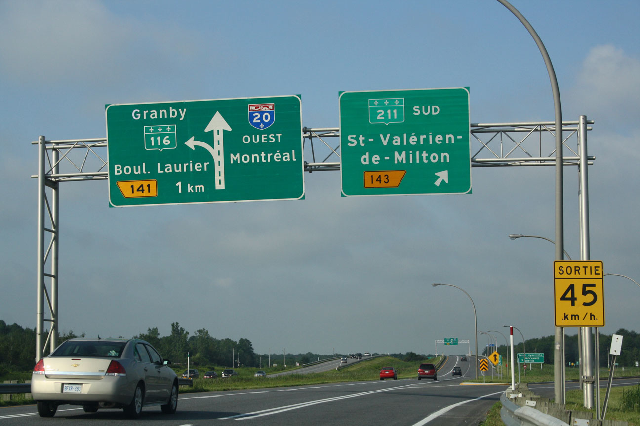
English: A new Clearview (left) and an old FHWA (right) highway signs in Saint-Simon-de-Bagot, Quebec, Canada, installed in June 2009 on Autoroute 20 westbound (To Montreal), at the exit 141. Notice the exit number and the route shields, on the new sign, who still use the FHWA typeface, and the "Granby" destination over the Route 116 shield instead of being below the name "Boulevard Laurier".
Français : Un nouveau panneau de signalisation, avec la fonte Clearview (gauche), et un ancien, avec la fonte FHWA (à droite) à Saint-Simon-de-Bagot, Québec, Canada, installé en Juin 2009 sur l'Autoroute 20 Ouest (Vers Montréal), à la sortie 141. Notez le numéro de sortie et les écussons de route, sur le nouveau panneau, qui utilisent encore la fonte FHWA, et la destination "Granby" au dessus de l'écusson de la Route 116 au lieu de se trouver en dessous du nom "Boulevard Laurier". |
| Datum | |
| Boarne | Eigen wurk |
| Auteur | SASgrafix |
| Camera location | | View this and other nearby images on: OpenStreetMap |
|---|
Lisinsje
| I, the copyright holder of this work, release this work into the public domain. This applies worldwide. In some countries this may not be legally possible; if so: I grant anyone the right to use this work for any purpose, without any conditions, unless such conditions are required by law. |
Triemskiednis
Klik op in datum/tiid om it bestân te besjen sa't it op dat stuit wie.
| Datum/Tiid | Miniatuer | ôfmjittings | Meidogger | Opmerking | |
|---|---|---|---|---|---|
| lêste | 29 sep 2009, 16.55 | | 1.296 × 864 (148 KB) | SASgrafix | {{Information |Description={{en|1=A new Clearview (left) and an old FWHA (right) highway signs in Saint-Simon-de-Bagot, Quebec, Canada, installed in June 2009 on Autoroute 20 westbound (To Montreal), at the exit 141. Notice the exit number and the route s |
Bestânsgebrûk
De neikommende side brûkt dit bestân:
Globaal bestânsgebrûk
De neikommende oare wiki's brûke dit bestân:
- Gebrûk op en.wikipedia.org
- Gebrûk op fr.wikipedia.org
- Gebrûk op hi.wikipedia.org